Coledale and Newlands circular from near Buttermere
Lake District Walk
Nat Park - Lake District - Lake District North Western Fells
Wainwrights - Ard Crags, Knott Rigg, Rannerdale Knotts, Wandope, Whiteless Pike
County/Area - Cumbria
Author - Stephen Starkey
Length - 9.0 miles / 14.6 km Ascent - 4160 feet / 1261 metres
Time - 8 hours 40 minutes Grade - hard
Maps 

| Ordnance Survey Explorer OL6 | Sheet Map | 1:25k | BUY |
| Anquet OS Explorer OL6 | Digital Map | 1:25k | BUY |
| Ordnance Survey Landranger 90 | Sheet Map | 1:50k | BUY |
| Anquet OS Landranger 90 | Digital Map | 1:50k | BUY |
Walk Route Description
Click image to see photo description.
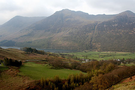
Buttermere, Coledale and Newlands are all synonymous with great walking. This Lake District walk aims to include some of the best views and ridges in all three areas in one long, but hugely enjoyable, day out.
There are 3 obvious possibilities for starting this route. One would be the small parking area at Hause Point (Grid Ref. NY162182). This option will replace the "out and back" to Rannerdale Knotts with a circular option, albeit a very steep ascent to start the day, but has the drawback of a long walk out from the last peak. Another option would be parking in Buttermere village (NY173169) - the best of the 3 options for those wanting to decamp straight in to a pub at the end of the walk, but this option involves a long, steep, knee-jarring descent at the end of the day.
The third option, and the one I used, was to park at Newlands Hause (Grid Ref NY192176) which gives the shortest, quickest descent at the end of the day. Based on parking at Newlands Hause, this route is involves 1,260m of ascent. Using either of the other start/finish options would increase both the length of the walk and the amount of ascent and descent.
Assuming you park at Newlands Hause start by following any of the clearly visible sheep tracks that contour around the slopes of Knott Rigg to intersect the clear grass path that leads down the shoulder of Knott Rigg. At some convenient point, drop down to Mill Beck, aiming for a point just NE of where a stream joins the beck at NY186178. Ford the beck and then traverse your way uphill to the uppermost of the obvious sheep tracks.
At the obvious intersection of a number of paths (Grid Ref NY179177), turn West to walk along the broad ridge over Low Bank and on to Rannerdale Knotts. Return by the same route and then turn to the North to start the ascent of Whiteless Pike, continuing to Wandope. On the route from Whiteless Pike towards Wandope, the OS Explorer map shows the main path bending round to Wandope with a minor track by passing Wandope to Crag Hill. However, on the ground, the main path by-passes Wandope with a minor grass path leading off to Wandope.
It is worth taking in the summit of Wandope in order to follow the path around the crest of Addacomb Hole with excellent views East of Crag Hill and the ridge to Causey Pike. Continue onto the summit of Crag Hill, from where you descend to the SE to follow the obvious path (part of the spectacular Coledale Horseshoe) across the exposed ridge of The Scar with fantastic views to both sides.
Continue over Sail, with wonderful views of Causey Pike ahead, and on to the col between Sail and Scar Crags. At the col, double back to the right descending on a clear path for approx. 50m until a clear, narrow grassy gully descends to the left (NY204204). On the OS map, the gully appears insignificant but it is much more prominent on the ground and much steeper than the map would have you think! Turn left to descend in the gully, which soon becomes a narrow scree gully, and continue the steep, exhilarating (but easy) descent of the gully until the head of the stream. From this point the left hand bank then offers the easiest descent to the valley below.
After fording Rigg Beck, make your way up the slopes of Ard Crags to the ridge. The ascent, though fairly steep, is nowhere near as difficult as it looks from the other side of the valley. A zig-zag route makes for a reasonable ascent, the direct route will test the legs and lungs after the earlier exploits. On reaching the ridge, Wainwright baggers may want to head East to get the summit of Ard Crags before returning West along the ridge to Knott Rigg. The ridge offers fantastic views of the Crag Hill - Sail - Scar Crag - Causey Pike ridge on the right and the amazingly steep drop in to Keskadale on the left.
From Knott Rigg take the fairly obvious path ahead for a knee jarringly steep descent - at which point you may be grateful for parking at Newlands Hause in order to halve the length of the final descent.
Other walks nearby
| Walk 2642 | Buttermere Horseshoe | very hard | 14.0 miles |
| Walk 1142 | Buttermere Circular | easy | 4.5 miles |
| Walk 2609 | Grasmoor via Crag Hill | mod/hard | 8.0 miles |
| Walk 2735 | Fleetwith Pike and Buttermere Circular | mod/hard | 8.5 miles |
| Walk 1153 | The High Stile Ridge | hard | 10.0 miles |
| Walk 1289 | Fleetwith Pike & Haystacks | moderate | 5.5 miles |
| Walk 2539 | Grasmoor and Rannerdale Knotts | moderate | 8.0 miles |
| Walk 1231 | Grasmoor via Whiteless Pike | moderate | 7.0 miles |
| Walk 2020 | Rannerdale Knotts and Crummock Water from Cinderdale Common | easy/mod | 2.5 miles |
| Walk 1187 | Robinson & Hindscarth | mod/hard | 6.5 miles |
Recommended Books & eBooks
Outdoor Adventures with Children - Lake District
 Guidebook to 40 outdoor adventures in the Lake District with children under 12, including walking, cycling, orienteering, paddling, boating, hostelling and more. Graded activities for varying age ranges or for families with children of different ages.
More information
Walking the Lake District Fells - Patterdale
 Part of the Walking the Lake District Fells series, this guidebook covers a wide range of routes to 35 Lakeland summits that can be climbed from Ambleside, Grasmere and Patterdale and the Thirlmere and Ullswater valleys, with highlights including Helvellyn and Fairfield. Suggestions for longer ridge routes are also included.
More information
Messaging & Social Media
Message Walking Britain and follow the latest news.

Mountain Weather
Stay safe on the mountains with detailed weather forecasts - for iOS devices or for Android devices.