Dunkery Beacon (short ascent)
Exmoor Walk
Nat Park - Exmoor
County/Area - Somerset
Author - Lou Johnson
Length - 2.5 miles / 4.1 km Ascent - 400 feet / 121 metres
Time - 1 hours 40 minutes Grade - easy/mod
Maps 

| Ordnance Survey Explorer OL9 | Sheet Map | 1:25k | BUY |
| Anquet OS Explorer OL9 | Digital Map | 1:25k | BUY |
| Ordnance Survey Landranger 181 | Sheet Map | 1:50k | BUY |
| Anquet OS Landranger 181 | Digital Map | 1:50k | BUY |
Walk Route Description
Click image to visit gallery of 6 images.
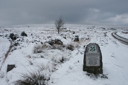
The high ground of the Exmoor National Park is rolling heather moorland. The highest point within the National Park is Dunkery Beacon (519 m) which is located at the eastern end of the moors. A minor road from Luccombe to Wheddon Cross contours across the moor some 400 feet below the summit. With a small car park conveniently located, the short walk to the summit is popular. This route adds a little more distance by taking you along the ridge for a short way before returning to the start.
The start is the small car park at Dunkery Gate (Grid ref. SS8954060). After parking take the direct path that heads approximately northeast up hill to the summit. The path is well trodden and navigation except in exceptional weather is not a problem. The summit is crowned with a trig pint and a large cairn. The views in good weather are superb with a large swathe of the National Park in view together with the North Somerset coast. With good visibility the mountains and coast of South Wales can also be seen.
To make the walk longer and more interesting, leave the summit by taking the path running just south of west towards a hedge line just under a mile away (Grid ref. SS880413). Just before reaching the hedge turn sharp left onto a wider track that will lead you back to the start. On your right are extensive views over the rolling hills that are typical of the southern section of the park.
The photos accompanying this walk were taken in February 2006 when snowfall occurred over a number of days. The paths in these conditions were covered in drifts and the going much harder than in normal weather conditions.
Other walks nearby
| Walk 1220 | Dunkery Beacon | moderate | 8.0 miles |
| Walk 1222 | Winsford Hill & the Allotment | moderate | 6.0 miles |
| Walk 3725 | Selworthy Beacon from Selworthy | easy/mod | 5.5 miles |
| Walk 1221 | Selworthy Beacon & North Hill from Bossington | moderate | 8.5 miles |
| Walk 1860 | The River Barle and Withypool from Tarr Steps | easy/mod | 7.5 miles |
| Walk 1669 | Anstey Gate & Hawkridge from Tarr Steps | moderate | 8.2 miles |
| Walk 2451 | Withypool & Barle Valley | easy/mod | 6.0 miles |
| Walk 2211 | Minehead to Dunster | easy | 5.0 miles |
| Walk 3386 | Barle Valley & Cow Castle from Simonsbath | easy/mod | 6.4 miles |
| Walk 1263 | The Doone Valley | moderate | 8.5 miles |
Recommended Books & eBooks
No suggestions for this area.Messaging & Social Media
Message Walking Britain and follow the latest news.

Mountain Weather
Stay safe on the mountains with detailed weather forecasts - for iOS devices or for Android devices.