Graveley and Warren's GreenWeston
Hertfordshire Walk
County/Area - Hertfordshire
Author - Donald Morton
Length - 7.0 miles / 11.4 km Ascent - 410 feet / 124 metres
Time - 4 hours 0 minutes Grade - easy/mod
Maps 

| Ordnance Survey Explorer 193 | Sheet Map | 1:25k | BUY |
| Anquet OS Explorer 193 | Digital Map | 1:25k | BUY |
| Ordnance Survey Landranger 166 | Sheet Map | 1:50k | BUY |
| Anquet OS Landranger 166 | Digital Map | 1:50k | BUY |
Walk Route Description
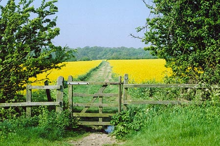
Click image to visit gallery of 4 images.
This Hertfordshire walk starts in Rowan Close, off Damask Green Road in Weston just before the Cricketer's Public House (Grid Ref TL258299). It is possible to park along Damask Green Road. At no time is this walk further than 3km from Stevenage, the first post-war New Town in England. And yet you would not know it. Apart from one isolated building, spectacularly and magnificently noticeable from a short stretch, it is a totally rural ramble peaceful and quiet over the open uplands of North Hertfordshire. A notable feature in the spring is the birdsong, not just in the woods and hedgerows, but rising overhead across the arable fields.
From Damask Green Road walk down Rowan Close (signposted as Bridleway to Graveley 2). At the end of the Close go through the gate and half left across the field to a gate visible on the other side. This turns out to be two gates: go through the right hand one and down the field edge, fence on left. At the end, go through a bridle gate and straight on along a field break between two large fields towards woods (How Wood). Go through a hedge and continue over a second field. Just before reaching the woods, turn left on a cross track which converges on the wood. Continue on with the edge of the woods on the right. Where the edge of the woods swings left, fork right through a narrow strip of woodland and then continue with the edge of the woods again on the right. Once past the woods, the path swings slightly left and twists between fields along a line of trees. After passing a copse on the left, curve right round the field edge. At the end of the field turn left and go down the field edge, hedge on left. Swing right, and start dropping down between fields, and then left with hedge on right. Finally the route becomes an enclosed path to emerge on a gravel drive in Graveley, with a Hertfordshire Way sign pointing right.
This walk, however, turns left to follow the Hertfordshire Way in the opposite direction back to Weston. Start by going past Graveley church - unfortunately not open; a plan in the porch indicates that part of the structure goes back to the 14th Century and earlier. Follow the drive round to the left; then at the T-junction turn left along the road for 250 metres. Just past the black and white "Cottage Rectory End" turn right onto Public Footpath 6. Go along the field edge, hedge on right, and at the end go through a hedge gap and turn left. Go along the field edge and, where the hedge on the left ends, continue on between fields. At the T-junction of paths turn left along the bridleway, hedge on right. This comes out at a road on a right angle corner. Continue by going straight on along the road. When it turns right follow it round (ignore Footpath 9 going straight on) but where it turns right again, turn left up a no through road.
Opposite the ruined church on the left (St Ethelreda's, once the church of the village of Chesfield now deserted except for the farm by the church) turn right - signed Hertfordshire Way! - along a broad green lane which becomes a narrower enclosed path before arriving at a road (Grid Ref TL254278). Turn left and follow this for about 450 metres. Where the road turns left, turn right on Footpath 27 to Warrens Green. Go along the concrete drive, follow it round left, cross the gravel - past barn conversions - and the lawn with pond on left to a stile crossing two fences on one piece of wood. Once over this go half left to the nearby metal kissing gate. Do NOT go through it but turn right to follow the field edge, hedge on left.
At field end, go through a kissing gate and straight on, still with hedge on left. After ignoring a footpath to the right, come out at a road. This is the hamlet of Warren Green. Turn left on the road and follow it round left (past a lovely thatched cottage). Ignore the two footpaths on the right at this bend but at the next left bend in the road go straight on through a kissing gate, along the field edge to the next kissing gate. Then go straight on to a stile visible ahead in what turns out to be a non existent fence. It does, however, mark the route which continues across parkland to a metal gate to the right of a group of trees.
Again, continue straight on and as you come out of the dip the next metal kissing gate appears ahead. From here the path curves with the edge of the wood on the right until it reaches a drive. Go over the stile on the right, cross the drive, and through the kissing gate. From here take the right hand path (marked Golden Jubilee Walk) going diagonally right - aim to the right of the house ahead and a gate into the woods becomes visible. Follow the path through the woods to a drive. Cross the drive and go straight on through a kissing gate (currently a recycled house gate). Go along the field edge, hedge on right, until you see a gate into the woods. Take the path through the woods and emerge at a kissing gate.
Go straight on over the field to a gate on the other side. Go through to a cross path. Turn left through another gate and immediately right to walk round two sides of a sports field to exit down a path leading through some houses, past Weston village hall, to a road. Turn left past the village green and left again into Damask Green Road. Go past the Red Lion and turn left one more time (signed Stevenage and still Damask Green Road) back to the start of the walk.
The start is the village of Northend where parking is available on Northend (street name). Park as close as you can to Seven Acres Lane (grid ref. ST779682). After parking walk up Seven Acres Lane following it around to the right. Continue ahead at the junction with Eagle Road and follow the lane as it bends left. Continue along the lane for about 800 metres ignoring the driveway on the right leading to Chilcombe House. Reaching a small stone building, take the steps to right into Chilcombe Bottom. Pass the former reservoir on your left to reach a gate by a building.
Other walks nearby
| Walk 1503 | Weston & Clothall circular Weston | easy | 5.5 miles |
| Walk 2970 | The Beane Valley from Walkern to Hertford | moderate | 14.3 miles |
| Walk 1265 | Clothall & Roe Green | easy/mod | 7.3 miles |
| Walk 1663 | Cottered Warren & Wakeley | easy | 6.4 miles |
| Walk 2221 | Circular from St Paul's Walden to Little Almshoe | easy/mod | 7.0 miles |
| Walk 2708 | Cuckolds Cross & Whitwell from St Paul's Walden | easy/mod | 7.0 miles |
| Walk 1118 | Roe Green and Sandon from Therfield circular | easy/mod | 7.3 miles |
| Walk 1812 | Therfield to Royston & Reed Circular | easy/mod | 10.0 miles |
| Walk 2107 | Reed to Nuthampstead Circular | easy/mod | 7.3 miles |
| Walk 1599 | Therfield Heath circular from near Royston | easy/mod | 6.5 miles |
Recommended Books & eBooks
No suggestions for this area.Messaging & Social Media
Message Walking Britain and follow the latest news.

Mountain Weather
Stay safe on the mountains with detailed weather forecasts - for iOS devices or for Android devices.