Earl Sterndale and High Wheeldon from Longnor
Peak District Walk
Nat Park - Peak District - Dove Valley Chrome Hill
County/Area - Staffordshire & Derbyshire
Author - Lou Johnson
Length - 6.0 miles / 9.8 km Ascent - 1400 feet / 424 metres
Time - 4 hours 20 minutes Grade - easy/mod
Maps 

| Ordnance Survey Explorer OL24 | Sheet Map | 1:25k | BUY |
| Anquet OS Explorer OL24 | Digital Map | 1:25k | BUY |
| Ordnance Survey Landranger 119 | Sheet Map | 1:50k | BUY |
| Anquet OS Landranger 119 | Digital Map | 1:50k | BUY |
Walk Route Description
Click image to visit gallery of 3 images.
This Peak District walk starts from the attractive North Staffordshire village of Longnor. It then crosses the Dove Valley into Derbyshire, passes through Earl Sterndale to climb High Wheeldon before re-crossing the Dove back into Staffordshire. The scenery en-route is varied with excellent views throughout. Although not included in this walk you pass close to Chrome and Parkhouse Hills, which could also be climbed if energy permits.
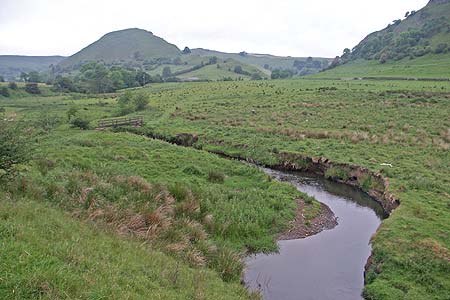
The start is the centre of the village where a cobbled car park (Grid ref. SK088649) usually has room for a car or two. Otherwise alternative parking is available elsewhere in the village. From the Market Place walk north along Chapel Street and continue across Church Street into a tarmac lane. Turn right onto the signed footpath, which leads you behind a modern bungalow development and down a bank to join the access track (Grid ref. SK087655) to Underhill Farm. Turn left along this and at a junction of tracks bear right and continue towards Yewtree Grange. Pass this building to its left and follow the track up to the road. Turn right along the road and after 300 metres take the signed footpath on the left that follows a track to some houses. The way ahead leaves this track and becomes a path dropping down the hillside to a footbridge over the River Dove (Grid ref. SK078665). Cross this bridge into Derbyshire and continue on the path to the tarmac lane. To your left is Chrome Hill, while ahead rises Parkhouse Hill. Both of these hills are formed from old coral reefs and an ascent of either or both could be added to this walk is energy permits!
Assuming you are not climbing either of the hills, turn right along the lane and after a few metres bear half left across the grass crossing the flank of Parkhouse Hill to a gate. The path continues through this field and another to reach the road (Grid ref. SK084668) between Glutton Bridge and Glutton Grange. Cross the road and take the stile opposite and begin the climb up the hill to Earl Sterndale. Crossing a rather awkward wall stile continue through a gate to the right of a water trough and continue downhill to the village arriving at the front of the "Quiet Woman" pub. Facing the pub, take the path to its right through the back yard with its turkeys and other assorted 'wildlife'. This continues uphill across fields before descending into the Dove Valley to reach a track (Grid ref. SK089663). Turn left along this passing through Underhill Farm. Turn left on Green Lane and walk up to the road. Continue ahead along the road passing the old quarry on your left that is very popular with climbers. Just past the quarry take the signed footpath on the right. This leads in a large loop to the trig point on the summit of High Wheeldon.
The view from here is superb with the Upper Dove Valley particularly noteworthy. Chrome and Parkhouse Hills are very evident in the scene as is Axe Edge Moor at the head of the valley. Having enjoyed the panorama return the way you came tracing you steps to Green Lane. Rather than turn right to Underhill Farm continue straight ahead along the lane over Beggar's Bridge and back into Staffordshire. The path leads into a track and climbs to "Top o' tha' Edge" where you join a road. Turn right into the village and return to the start of the walk. At the end of a walk, Longnor offers a number of opportunities for refreshment including pubs with the converted Market Hall housing a cafe and craft shop recommended.
Other walks nearby
| Walk 1861 | Chrome and Parkhouse Hills from Earl Sterndale | easy/mod | 5.0 miles |
| Walk 1185 | Chrome Hill (Dragon's Back) from Hollinsclough | easy/mod | 4.5 miles |
| Walk 2531 | Upper Dove Valley | moderate | 7.5 miles |
| Walk 2545 | High Edge & Chrome Hill from Hollinsclough | moderate | 8.5 miles |
| Walk 2837 | Parkhouse & Chrome Hills from Longnor | easy/mod | 6.7 miles |
| Walk 3445 | The Dragon's Back (Chrome Hill) from Hollinsclough | moderate | 4.5 miles |
| Walk 3709 | Sparklow, Crowdicote & Pilsbury Circular | easy/mod | 9.0 miles |
| Walk 1042 | Pilsbury Castle | easy/mod | 5.5 miles |
| Walk 2301 | Biggin & Parsley Hay from Hartington | easy/mod | 9.5 miles |
| Walk 2079 | Beresford & Wolfescote Dales from Hartington | easy/mod | 7.2 miles |
Recommended Books & eBooks
Dark Peak Walks
 Guidebook to 40 walks in the Dark Peak area of the Peak District National Park. 35 circular routes for most abilities, from 8km to 19km, around Edale, Marsden, Fairholmes, Baslow and Castleton, including Kinder Scout and Mam Tor, and 5 longer (25km to 45km) routes highlighting the best of the Gritstone Edges, High Moorland and Deep Valleys.
More information
Great Mountain Days in the Pennines
 An inspirational guidebook to 50 classic walks on the rolling Pennine landscape. The graded routes, between 6 and 13 miles in length, cover classic Pennine fells and moorland such as Whernside, Ilkley Moor and Pendle Hill; exploring the North and South Pennines, Yorkshire Dales, Howgills and Dark Peak. Many routes are also suited to fell running.
More information
Messaging & Social Media
Message Walking Britain and follow the latest news.

Mountain Weather
Stay safe on the mountains with detailed weather forecasts - for iOS devices or for Android devices.