Countisbury and Watersmeet from Lynmouth
Exmoor Walk
Nat Park - Exmoor
County/Area - Devon
Author - Lou Johnson
Length - 4.5 miles / 7.3 km Ascent - 1600 feet / 485 metres
Time - 3 hours 50 minutes Grade - easy/mod
Maps 

| Ordnance Survey Explorer OL9 | Sheet Map | 1:25k | BUY |
| Anquet OS Explorer OL9 | Digital Map | 1:25k | BUY |
| Ordnance Survey Landranger 180 | Sheet Map | 1:50k | BUY |
| Anquet OS Landranger 180 | Digital Map | 1:50k | BUY |
Walk Route Description
Click image to visit gallery of 9 images.
This half day walk from Lynmouth includes a spectacular section of coast, high pastures, mature deciduous woodland, and riverside section beside the River Lyn. Lynmouth was the scene of the devastating flood of 1952 when many people lost their lives. The disaster was the result of a flash flood with high levels of water rushing down the Lyn Rivers from Exmoor to the sea. Today the scars have healed and Lynmouth is now a bustling seaside village in high season. This walk was researched in February when there were few visitors and parking was easy although most of amenities were open for business.
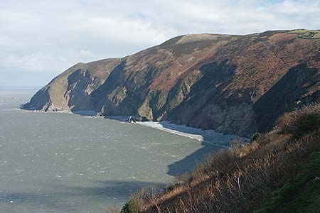
Parking is available on the street on the west side of the river during winter. At busy times you may need to use one of the car parks that are signed off the A39. The start is the seafront opposite the lower station of the funicular railway (Grid ref SS722496) that links Lynmouth with Lynton. Turn right and follow the river upstream passing the small pier on your left. Cross the substantial foot bridge over the River Lyn following the South West Coast Path signs. Ahead you can see Foreland Point with Butter Hill to its immediate right. This hill is nearly a thousand feet high and gives some impression of the height of the cliffs in this locality.
The path begins to climb across the face of the cliffs, gaining height steadily and in a few places quite steeply. Passing beside the A39 the path ahead is never in doubt and your efforts are rewarded with increasingly spectacular views. On a fine day you can see across the Bristol Channel to South Wales and the Brecon Beacons as well as enjoying the increasingly airy path as you climb up to the Church at Countisbury (Grid ref. SS747498).
Turn right through Countisbury churchyard and walk down the lane to the main road. Cross the busy road with care and go left for a few metres to locate a footpath on your right. Follow the clear path across South Hill Common and descend to the edge of Horner's Neck Woods (Grid ref. SS747490). As you cross these open meadows you get an excellent view of the wooded combes or valleys typical of Exmoor. The path follows a short ridge before starting to descend to Watersmeet in the valley via a series of zigzags. Reaching the valley path turn right and in a short distance you arrive at Watersmeet House (National Trust with refreshments in season). The junction of the two rivers here is quite spectacular after rain and you can try to imagine in the enormity of the flood when disaster hit in 1952.
The onward route runs parallel to the river all the way to Lynmouth. However, in places the path climbs away from the valley bottom before returning to run alongside the river once more. Signage and waymarking is good, and it is important that you follow the path to Lynmouth. If in doubt take the widest path and be prepared for some ascent. Reaching Lynmouth cross the river either by the footbridges or road bridge to regain the start.
Other walks nearby
| Walk 3391 | Valley of Rocks frrom Lynton | easy/mod | 3.8 miles |
| Walk 3729 | Foreland Point | moderate | 5.0 miles |
| Walk 3390 | Heddon Valley from Woody Bay | moderate | 5.3 miles |
| Walk 1263 | The Doone Valley | moderate | 8.5 miles |
| Walk 1262 | Watersmeet & Foreland Point | mod/hard | 10.5 miles |
| Walk 3394 | Holdstone Down & Trentishoe | moderate | 7.0 miles |
| Walk 1727 | Shallowford, Hoar Oak Tree & The Chains | moderate | 11.7 miles |
| Walk 2387 | Pinkery Pond Circular | easy/mod | 5.8 miles |
| Walk 3386 | Barle Valley & Cow Castle from Simonsbath | easy/mod | 6.4 miles |
| Walk 3393 | Great Hangman Hill | easy/mod | 4.3 miles |
Recommended Books & eBooks
South West Coast Path Map Booklet - Minehead to St Ives
 Map of the northern section of the 630 mile (1014km) South West Coast Path National Trail. Covers the trail from Minehead to St Ives along the north Devon and Cornish coastline. This convenient and compact booklet of Ordnance Survey 1:25,000 maps shows the route, providing all of the mapping you need to walk the trail in either direction.
More information
South West Coast Path Map Booklet - St Ives to Plymouth
 Map of part of the southern section of the 630 mile (1014km) South West Coast Path National Trail. Covers the trail from St Ives to Plymouth along the west Cornwall and Devon coastline. This convenient and compact booklet of Ordnance Survey 1:25,000 maps shows the route, providing all of the mapping you need to walk the trail in either direction.
More information
Messaging & Social Media
Message Walking Britain and follow the latest news.

Mountain Weather
Stay safe on the mountains with detailed weather forecasts - for iOS devices or for Android devices.