Highgate Common and Surrounding Country
Staffordshire Walk
County/Area - Staffordshire - South Staffordshire
Author - Peter Lane
Length - 6.0 miles / 9.8 km Ascent - 200 feet / 61 metres
Time - 3 hours 10 minutes Grade - easy
Maps 

| Ordnance Survey Explorer 218 | Sheet Map | 1:25k | BUY |
| Anquet OS Explorer 218 | Digital Map | 1:25k | BUY |
| Ordnance Survey Explorer 219 | Sheet Map | 1:25k | BUY |
| Anquet OS Explorer 219 | Digital Map | 1:25k | BUY |
| Ordnance Survey Landranger 138 | Sheet Map | 1:50k | BUY |
| Anquet OS Landranger 138 | Digital Map | 1:50k | BUY |
Walk Route Description
Click image to visit gallery of 9 images.
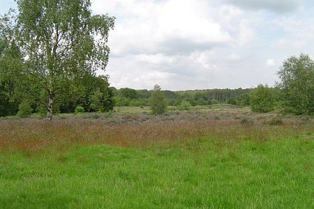
A rural Staffordshire walk with an unexpected surprise in store! This pleasant rural walk in South Staffordshire visits the ever popular Highgate Common and provides a chance to explore the surrounding countryside too. Ideal for those new to walking, route finding is not too hard. The return route is along the Staffordshire Way and holds a surprise in store! Long trousers are strongly advised as the route can be somewhat overgrown in places.
Highgate Common has many car parks from which this route may be accessed, but for the purposes of this route, the one at grid reference SO837896 has been chosen (not least because I like to start a walk with an ice cream!). From here the main part of the Common opens out before you. Head virtually due East from the car park (right) towards a fenced, rectangular enclosure planted with trees all along its boundary (clearly marked on OS maps). Once you reach it, a well defined path runs along its edge. Head North East along the flank, following the path until it emerges at a road (White House Lane).
Turn square left here along a bridlepath with a car park a few metres away. From the car park take the right hand narrow path (a faint path on the Explorer map and unmarked on the Landranger map) that follows the fence line. This meets up with the Staffordshire Way, where you continue on this route to a car park. If in doubt, keep right but don't cross the fence line.
Moments before reaching the car park, turn left and bear left following the narrow path along another fence line as it opens up into Forest Lane. Cross the road to Halfpenny Green and continue along Water Lane, passing under the flight path of the aircraft using Wolverhampton Airport (a somewhat grandiose title for what used to be a World War 2 aerodrome). Formerly Halfpenny Green Airfield, this was actually not the setting for the making of a 'stiff upper lip' war time film starring John Mills called "The Way to the Stars", despite that film's location being referred to as RAF Halfpenny Field.
At the end of Water Lane, cross straight over the road, pass Crab Mill Farm down the appropriately named Green Lane. This is actually no more than a right of way that runs to the right of the hedge line past some derelict RAF buildings now the domain of grazing sheep. After a while the path switches to the left side of the hedge and back to the right again. Just keep the same general direction and follow the field boundaries and you will eventually emerge from a short, claustrophobic section of the route onto Lutley Lane. This is the most overgrown section of the route.
Turn left along the lane for approximately 150 metres where a less than obvious fingerpost indicates the Staffordshire Way heading off left. This is now the return route and well marked. At Mere Hall comes the promised surprise: grazing llama! In an instant one is transported to the High Andes in the midst of rural Staffordshire!
Having recovered from the shock of seeing the aforementioned antipodean beasts, the route passes between two lakes and continues across fields back to a road. Turn right from the gates onto the road and then left up Gospel Ash Road, past the turning to Swindon and Himley and in a few metres beyond the Stafforshire Way continues right along a narrow passage with a fence to the left.
At a complex junction of five paths in the woods, the Staffordshire Way continues slightly left of straight ahead. Our path is the route furthest most to the right, turning almost due South initially. This emerges at a road and the Modellers' Car Park on the Common. Sadly, the modellers are no longer allowed to fly their model aircraft in competition with a plethora of the real thing passing overhead with alacrity!
You should now be on open Common. Explore at will if you so desire. The route back to the car park is generally South West. Head downhill maintaining the same general direction from the Modellers' Car Park and upon reaching a gravel path, turn right and follow this past a small pond to the starting point.
Other walks nearby
| Walk 2874 | Enville Estate and the Sheepwalks | easy | 4.0 miles |
| Walk 3003 | Kinver Edge & Blakeshall from Holy Austin Rock | easy | 4.3 miles |
| Walk 2834 | Kinver Edge circular | easy | 4.2 miles |
| Walk 3241 | Kinver Edge & Holy Austin Rock | easy | 2.6 miles |
| Walk 1806 | Kinver Stroll | easy | 2.0 miles |
| Walk 2024 | Kinver Edge, South Staffordshire | easy/mod | 6.0 miles |
| Walk 1451 | Dudmaston Estate circular | easy | 4.0 miles |
| Walk 1603 | Shatterford Wood and Castle Hill circular | easy/mod | 5.5 miles |
| Walk 2092 | Highley from the Severn Valley Country Park | easy/mod | 4.5 miles |
| Walk 2807 | The River Severn from Hampton Loade to Bridgnorth | easy/mod | 6.0 miles |
Recommended Books & eBooks
Walking in the Peak District - White Peak East
 Guidebook describing 42 half-day and day walks in the limestone landscapes of Derbyshire's White Peak, part of the Peak District National Park. One of two volumes, this book covers the east of the region, with potential bases including Bakewell, Eyam, Castleton, Birchover, Matlock and Wirksworth.
More information
Messaging & Social Media
Message Walking Britain and follow the latest news.

Mountain Weather
Stay safe on the mountains with detailed weather forecasts - for iOS devices or for Android devices.