Gray Crag and Pasture Beck from Hartsop
Lake District Walk
Nat Park - Lake District - Lake District Far Eastern Fells
Wainwrights - Gray Crag
County/Area - Cumbria
Author - Lou Johnson
Length - 5.5 miles / 8.9 km Ascent - 2200 feet / 667 metres
Time - 5 hours 0 minutes Grade - moderate
Maps 

| Ordnance Survey Explorer OL5 | Sheet Map | 1:25k | BUY |
| Anquet OS Explorer OL5 | Digital Map | 1:25k | BUY |
| Ordnance Survey Landranger 90 | Sheet Map | 1:50k | BUY |
| Anquet OS Landranger 90 | Digital Map | 1:50k | BUY |
Walk Route Description
Click image to visit gallery of 12 images.
This short Lake District circular walk provides excellent views and great walking. The start is the pretty village of Hartsop where some cottages still retain their spinning galleries. The climb onto Gray Crag is steep but once this ascent has been completed the walk is relatively straightforward to reach Thornthwaite Beacon. A descent to Threshthwaite Mouth is followed by a beautiful valley walk alongside Pasture Beck back to the start.
There is limited parking at the end of the lane through Hartsop village (Grid ref. NY409130). From here walk up the track towards Hayeswater, keeping the extensive sheep-pens on your right. Descend to cross Hayeswater Gill by a bridge (Grid ref. NY416128). The track starts to climb with Gray Crag to your right. The start of the path is not too clear and some detective work is required at grid ref. NY420129 where you leave the main track and start the climb over grass. After a short way the route steepens and the path becomes clear. After the initial steep section the gradient eases and the route slants left across the end of Gray Crag before trending right to gain the ridge.
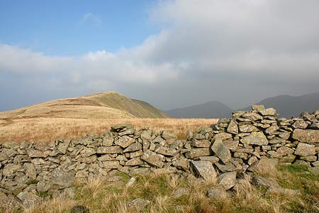
The bulk of the ascent is now over and the walking becomes easier with improving views in all directions across the Lake District. To the left lies High Street and to your right the parallel ridge of Hartsop Dodd. Behind lie Brock Crag, the Angletarn Pikes and Rest Dodd amongst other fells. Reaching the first summit you lose height before reaching a higher top (Grid ref. NY429110). After this there is a brief descent and all that remains is a short climb onto Thornthwaite Beacon with its large cairn. From here the views open up to the south with Lake Windermere a distinctive landmark.
The descent begins here with the path down to Threshthwaite Mouth heading northwest. The path is quite loose in places and makes this a rather unpleasant descent. However the view ahead to Caudale Moor does provide some compensation. Reaching the col (Grid ref. NY426102), turn right through the wall and descend into the u-shaped valley that is home to Pasture Beck. The first section of steep path has been improved in recent years and once this has been completed the remaining route is easy and relaxed.
All the way down the valley the slopes of Gray Crag dominate on your right as delightful Pasture Beck tumbles down the valley. Evidence of glacial activity in the past can be seen in the moraines scattered about the valley floor. Nearing Hartsop the path becomes a track which drops down to cross Pasture Beck over a stone arch bridge. On the other side turn left down the track and you are soon back at the start.
Other walks nearby
| Walk 1110 | Angletarn Pikes | moderate | 7.0 miles |
| Walk 2060 | The Angletarn Pikes and Brock Crags from Hartsop | moderate | 8.0 miles |
| Walk 3388 | Hayeswater and Angle Tarn from Hartsop | mod/hard | 11.5 miles |
| Walk 2386 | Red Screes via Dove Crag | mod/hard | 8.6 miles |
| Walk 1230 | Birks & Arnison Crag | moderate | 5.5 miles |
| Walk 1520 | Helvellyn & Fairfield Horseshoe from Patterdale | very hard | 13.0 miles |
| Walk 2047 | Place Fell | moderate | 7.5 miles |
| Walk 2425 | Boredale Circular from Patterdale | mod/hard | 11.5 miles |
| Walk 3670 | Angle Tarn and Hayeswater | moderate | 8.3 miles |
| Walk 1156 | Helvellyn via Striding Edge | hard | 9.5 miles |
Recommended Books & eBooks
Walking the Lake District Fells - Langdale
 Part of the Walking the Lake District Fells series, this guidebook covers a wide range of routes to 25 Lakeland summits that can be climbed from the Great Langdale valley, Ambleside and Grasmere, with highlights including Scafell Pike, Bowfell, the Langdale Pikes and Helm Crag (the Lion and the Lamb). Includes suggestions for longer ridge routes.
More information
Lake District: Low Level and Lake Walks
 This guidebook describes 30 of the best low-level walks in the Lake District. From delightful wooded glades and sparkling tarns, to waterfalls and glacier-carved valleys towered over by craggy mountains. The walks described aim to seek out the best walking that the lower areas of the Lake District have to offer.
More information
Messaging & Social Media
Message Walking Britain and follow the latest news.

Mountain Weather
Stay safe on the mountains with detailed weather forecasts - for iOS devices or for Android devices.