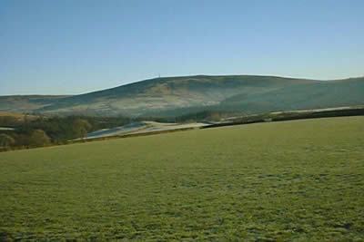
Calfield Rig & Mid Hill from Langholm
Dumfries and Galloway Walk
County/Area - Dumfries and Galloway
Author - Tom Hutton
Length - 6.7 miles / 10.9 km Ascent - 1300 feet / 394 metres
Time - 4 hours 40 minutes Grade - easy/mod
Maps 

| Ordnance Survey Explorer 323 | Sheet Map | 1:25k | BUY |
| Anquet OS Explorer 323 | Digital Map | 1:25k | BUY |
| Ordnance Survey Landranger 79 | Sheet Map | 1:50k | BUY |
| Anquet OS Landranger 79 | Digital Map | 1:50k | BUY |
Walk Route Description
Click image to visit gallery of 7 images.
Although it is not a "tiger" walk, this circular ridge walk on gently rolling hills on the edge of the border hills is a very rewarding excursion. It offers a superb set of varied panoramas as you traverse the ridge. You can see to Criffel beyond Dumfries, across the Solway Plain to the northern hills of the Lake District, the North end of the Pennines and the many hills of Eskdale and the Ewes Valley. The walks starts through woodland and unfolds its treats as you go along. Because of the circular nature of the walk, the views are constantly changing. Underfoot going is generally good but there are some quite wet bits in the bottoms of the little dips of the ridge.
From the car park (Grid ref. NY363846) walk into the town and turn right across the Town Bridge. Take the first left over the bridge and follow the River Esk, turning right at the Church and following the Wauchope until you turn left across a bridge into the Buccleuch Park. In the park take the right hand path and climb the steps leading out of the park. Go through the hedge and turn left, then in 20 metres turn right on Gaskells Walk. Follow this fine path as it swings round to run above the Wauchope Water through mature woodland. For part of the way, the river is in a miniature gorge below you.
At the end of the path, turn right on the road and left on the minor road leading to Becks Farm. Follow this road as it climbs round several bends. The hill section of this walk gradually comes into view ahead and to the right. At Becks, turn left on a track. Pass the access track to Calfield and continue for a further kilometre, the track getting a little rougher. At the end of the track, go through the gate and turn right to start climbing close to the dyke.
There is no clear path and some of the ground is wet, but a way can be found. At the top of the dyke, go over the stile and continue on the open hill, keeping to the highest ground and climbing steadily north-west to reach the top of Calfield Rig at 319 metres (1045 feet). There are already extensive views, especially to the south. Keep on the ridge heading north. The ground dips a little and then climbs gradually to Craighope Head. Cross the stile at the fence junction and continue to another fence junction. Cross this also and make the short climb to Black Knowe at 326m/1068ft. Much of Eskdale can be seen from here, and in clear conditions the panorama reaches far beyond, to the Solway Firth and the higher hills of northern Lakeland.
Return to the fence and head east along it towards the day's final top on Mid Hill, an easy kilometre away. Mid Hill is 327m/1070ft and commands another wonderful view. It is a place to linger on a good day. When you are ready to leave, head down beside the fence towards Langholm. Cross an area of wet ground, then reach a ladder stile at a dyke. From here follow a little path in the grass over Meikleholm Hill, giving more lovely views across the Muckle Toon. The path leads to old foundations on the site of a former TV mast. From here, take the right-hand of two faint paths to curve down and pass to the right of a large water tank. Reach a track and follow it left then sharply right to run down to a gate at the top of a fenced lane. Follow this lane down past houses and at an open area go briefly left then right down a track. Turn left into Eskdaill Street, turn left here and at the road end go right to return to the town centre and the car park.
The walk is waymarked as part of the Langholm Walks Project and is one of ten varied waymarked walks in the area. Copies of the guidebook can be obtained free of charge by mail from the Langholm Initiative Office, High Street, Langholm, DG 143 0DH, or by e-mailing: info@langholmwalks.co.uk. Otherwise these booklets may be bought in the town from various outlets. A beautifully illustrated book describing 27 walks in the area is also available.
Other walks nearby
| Walk 2473 | Bull Crag Peninsula (Kielder Water) | easy/mod | 6.3 miles |
| Walk 3612 | Ettrick Hills Horseshoe | mod/hard | 8.0 miles |
| Walk 2045 | Capel Fell via Sailfoot Law & Broken Back Hill | moderate | 5.8 miles |
| Walk 2008 | Hart Fell via Saddle Yoke & the Black Hope Horseshoe | mod/hard | 8.5 miles |
| Walk 2006 | Grey Mare's Tail & White Coomb | mod/hard | 7.2 miles |
| Walk 3343 | Hadrian's Wall, Walltown Crags & Aesica | easy/mod | 5.0 miles |
| Walk 3759 | St. Mary's Loch Circular | easy/mod | 7.5 miles |
| Walk 2035 | Hart Fell via Hartfell Spa | moderate | 7.2 miles |
| Walk 2280 | Hart Fell & Whitehope Heights | moderate | 8.4 miles |
| Walk 2050 | The Crown of Scotland | moderate | 9.0 miles |
Recommended Books & eBooks
No suggestions for this area.Messaging & Social Media
Message Walking Britain and follow the latest news.

Mountain Weather
Stay safe on the mountains with detailed weather forecasts - for iOS devices or for Android devices.