Southwold
Suffolk Coasts and Heaths Walk
Region - Suffolk Coasts and Heaths
County/Area - Suffolk
Author - Suffolk Coast & Heaths AONB
Length - 4.0 miles / 6.5 km Ascent - 50 feet / 15 metres
Time - 2 hours 0 minutes Grade - easy
Maps 

| Ordnance Survey Explorer 231 | Sheet Map | 1:25k | BUY |
| Anquet OS Explorer 231 | Digital Map | 1:25k | BUY |
| Ordnance Survey Landranger 156 | Sheet Map | 1:50k | BUY |
| Anquet OS Landranger 156 | Digital Map | 1:50k | BUY |
Walk Route Description
Click image to see photo description.
A circular tour exploring the harbour, estuary, creeks and marshes - home to some fascinating wildlife - which surround this charmingly elegant historic seaside town. The walk can be reached by train (Lowestoft or Ipswich) to Darsham from where one can take the X99 bus, part of the service between Lowestoft and Ipswich, to Southwold. Stout footwear is advised, as some areas are boggy.
Much of the ancient town of Southwold, overlooking Sole Bay, scene of a famous sea-battle in 1672, was destroyed by fire in 1659. However, examples of older buildings still remain including the magnificent Church dedicated to St Edmund (1460) and an Elizabethan house in the High Street where James, Duke of York, brother of Charles II had his headquarters. The haphazard grouping of houses of various architectural designs, Dutch and Flemish, Regency and Victorian add to its distinctive charm.
Southwold lies in the heart of the Suffolk Coast & Heaths Area of Outstanding Natural Beauty. Attractive, wildlife rich pastoral land including the common, bequeathed to the Borough in 1509 and the abutting Town Marshes surround the town on three sides.
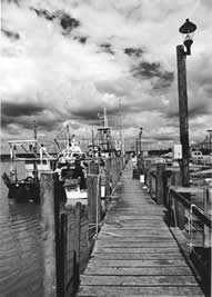
The walk starts at the Harbour Car Park (grid ref TM505748) reached by following Ferry Path to the Harbour. Close to the harbour entrance is the Alfred Corry Museum, which charts the history of the local lifeboat service, housed in the old Cromer Lifeboat shed; a Grade II listed building moved to Southwold in 1998.
From the Harbour take the broad track between the Town Marshes and the River Blyth inland. Once a busy commercial waterway and harbour for ocean going sailing ships, the estuary entrance now hosts a picturesque flotilla of yachts, pleasure craft and longshore fishing boats.
Reaching the Bailey Bridge, which rests on the piles of the old narrow gauge railway line, closed in 1929, follow the path right and cross the bed of the old railway on to the embankment beside Buss Creek. Silting has narrowed the channel, once broad enough to allow moorage for substantial sailing vessels, but in so doing has created a rich wildlife habitat for waders such as the Shellduck and Redshank.
Cross the A1095 at Mights Bridge, the only road link to Southwold and follow the embankment path past the Boating Lake and on to the Beach Car Park. At this point the path joins the long distance Suffolk Coast & Heaths Path that stretches some 50 miles from Lowestoft to Felixstowe before joining the Stour & Orwell Walk.
Continue south past the Pier, now being renovated and extended and along the cliff top to Gun Hill which takes its name from the six 18-pounder culverins, muzzle loading guns, cast in the reign of Elizabeth I.
Other walks nearby
| Walk 1775 | Walberswick Circular | easy | 4.5 miles |
| Walk 3603 | Blythburgh from Wenhaston | easy | 5.0 miles |
| Walk 1529 | Aldeburgh and Thorpeness Circular | easy/mod | 8.5 miles |
| Walk 2237 | Somerleyton & Herringfleet Hills | easy | 3.5 miles |
| Walk 2428 | The Rivers Ore & Alde from Orford | easy/mod | 11.0 miles |
| Walk 2075 | Tyrrel's Wood and Boudicca Way | easy/mod | 8.5 miles |
| Walk 1834 | Shelton & Fritton Common from Tyrrels Wood | easy/mod | 7.0 miles |
| Walk 2446 | Rockland St Mary Circular | easy/mod | 8.1 miles |
| Walk 3348 | River Yare & Claxton from Rockland Staithe | easy | 5.2 miles |
| Walk 2239 | River Bure and Tunstall Dike from Acle | easy | 6.1 miles |
Recommended Books & eBooks
Suffolk Coast and Heath Walks
 Guidebook to three long-distance routes exploring the varied landscapes of the Suffolk Coast and Heaths AONB. The Suffolk Coast Path covers 55 to 60 miles from Lowestoft to Felixstowe. The Stour and Orwell Walk is 40 miles from Felixstowe to Cattawade near Manningtree, while the Sandlings Walk is 59 miles from Ipswich to Southwold.
More information
Messaging & Social Media
Message Walking Britain and follow the latest news.

Mountain Weather
Stay safe on the mountains with detailed weather forecasts - for iOS devices or for Android devices.