Rannerdale Knotts and Crummock Water from Cinderdale Common
Lake District Walk
Nat Park - Lake District - Lake District North Western Fells
Wainwrights - Rannerdale Knotts
County/Area - Cumbria
Author - John Paterson
Length - 2.5 miles / 4.1 km Ascent - 850 feet / 258 metres
Time - 2 hours 10 minutes Grade - easy/mod
Maps 

| Ordnance Survey Explorer OL4 | Sheet Map | 1:25k | BUY |
| Anquet OS Explorer OL4 | Digital Map | 1:25k | BUY |
| Ordnance Survey Landranger 90 | Sheet Map | 1:50k | BUY |
| Anquet OS Landranger 90 | Digital Map | 1:50k | BUY |
Walk Route Description
Click image to visit gallery of 4 images.
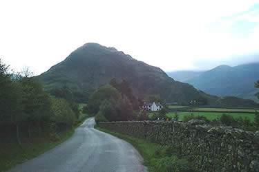
This is a straightforward but delightful short Lake District circular walk with a steep start and an easy finish. The views are excellent and the walk is ideal for a half day or an evening and, because the only rock is met early on, is suitable for young children (with a head for heights) who should not get too tired on the excellent descent path down Rannerdale. There are two good car parking points. The south west ridge of Rannerdale Knotts forces the B5289 Lorton to Buttermere road to hug Crummock water at Hause Point (GR 162182). There is roadside parking here for about 6 vehicles. If these spaces are full then there are 2 good off road car parks at Cinderdale Common just north of Rannerdale Cottage (GR NY162194) with a walk along the road of about half a mile to Hause Point.
From the road at the north side of Hause Point climb on a green path to quickly reach the saddle where the ridge steepens. Follow the direct line of the ridge on a grassy path for a few hundred yards until rocky crags are seen above. Strike out left to take the newly restored path which climbs steeply through a break in the crags. Once the steep part is over, the path meanders upwards mostly on grass, with minor easy sections on rock, to the summit. The excellent views from the summit take in the length of Crummock Water with a glimpse of Loweswater to the north and, to the south Buttermere and the High Stile range.
The difficulties of the walk are now over. To the south east the almost level hump backed ridge of Low Bank extends for about a mile with the valley of Rannerdale to the left and Crummock Water to the right. Follow the ridge until views open up of the Buttermere to Newlands Hause road. Now look for a saddle to your left which marks the top of Rannerdale - with the route to Whiteless Pike and Wandope rising above it. Drop down to the saddle and do a "U" turn to take the path down Rannerdale. This path is of an excellent gradient on good turf - one could wish that more descent paths were like it! Today, the peace and beauty of Rannerdale contrasts with the scene after the Norman conquest when the invading Norman army was lured into an ambush by the local Norse settlers and slaughtered. Local legend has it that the bluebells, for which Rannerdale is famous each spring, mark the site of the battle.
At the foot of Rannerdale a footbridge crosses the beck to your right. If you parked at Cinderdale Common - cross the foot bridge and follow the path down the valley back to the car park. If you parked by the road at Hause Point - don't cross the bridge but follow the path to your left which circles the foot of the fell and brings you back to Hause Point.
Other walks nearby
| Walk 2539 | Grasmoor and Rannerdale Knotts | moderate | 8.0 miles |
| Walk 2021 | Whiteside, Hopegill Head & Grisedale Pike | moderate | 7.5 miles |
| Walk 1142 | Buttermere Circular | easy | 4.5 miles |
| Walk 2609 | Grasmoor via Crag Hill | mod/hard | 8.0 miles |
| Walk 2735 | Fleetwith Pike and Buttermere Circular | mod/hard | 8.5 miles |
| Walk 1290 | Mellbreak | moderate | 7.0 miles |
| Walk 3676 | Hen Comb from Loweswater | moderate | 5.4 miles |
| Walk 2642 | Buttermere Horseshoe | very hard | 14.0 miles |
| Walk 1732 | Coledale and Newlands circular from near Buttermere | hard | 9.0 miles |
| Walk 1011 | Knott Rigg and Ard Crags | easy/mod | 3.5 miles |
Recommended Books & eBooks
Hadrian's Wall Path
 Hadrians Wall Path guidebook to walk the 84 mile National Trail. Described in both directions, the main description is west to east between Bowness-on-Solway and Wallsend, Newcastle, with extensions to Maryport and South Shields. With extensive historical information related to this World Heritage site and separate 1:25,000 OS map booklet included.
More information
The Cumbria Way
 A guidebook to the 73 mile Cumbria Way, an easy long-distance walk though the heart of the Lake District National Park, from Ulverston in the south to Carlisle in the north, with good transport links to either end. The route is largely low-level but this guide offers alternative mountain days to climb some of the famous fells en route.
More information
Messaging & Social Media
Message Walking Britain and follow the latest news.

Mountain Weather
Stay safe on the mountains with detailed weather forecasts - for iOS devices or for Android devices.