Abernethy Forest, Cairngorms
Cairngorms Walk
Nat Park - Cairngorms - Cairngorm North
County/Area - Highland
Author - Mountain Innovations
Length - 10.2 miles / 16.6 km Ascent - 1080 feet / 327 metres
Time - 6 hours 10 minutes Grade - easy/mod
Maps 

| Ordnance Survey Explorer OL57 | Sheet Map | 1:25k | BUY |
| Anquet OS Explorer OL57 | Digital Map | 1:25k | BUY |
| Ordnance Survey Landranger 36 | Sheet Map | 1:50k | BUY |
| Anquet OS Landranger 36 | Digital Map | 1:50k | BUY |
Walk Route Description
Click image to visit gallery of 2 images.
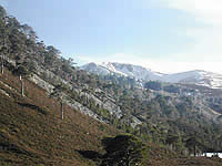
A hike into Britain's least-touched habitat. This route gives you a real taste of what the Highlands must have been like before the Jacobite rebellion of 1745. Forming the heart of the massive Abernethy nature reserve, this remaining remnant of the great Forest of Caledon is home to a good number of rare and unique species of bird and mammal, not least the pine marten and Capercaillie. The area you pass through is much less frequented and offers you hidden and dramatic views deep into the heart of the Cairngorms. This walk is an absolute delight during the later part of July and early August, when the heather is out in full bloom.
Your starting point is Forest Lodge (NJ019161).To reach the start of the walk from Boat of Garten (near Aviemore) you follow directions to Loch Garten and then on to Tulloch, (turning first right after the loch). 1.5km further on, at the prominent red letter box in Tulloch, the road makes a sharp left hand bend. 2km after this is the turning to Forest Lodge on the right, which is not sign posted. You will recognise this turning from the V-shaped entrance (2 entry points immediately after one another leading to the same track). This is a well-maintained dirt track and no problem for normal road vehicles. There is room to park by the signs indicating no further access by unauthorised vehicles, 2.5km along the dirt track.
The walk heads off in a north-easterly direction for a short distance past the stalkers' cottages then dropping down to a bridge over the River Nethy. You will then make a gentle meandering climb along a good forest track in a generally southerly direction above the east bank of the River Nethy. The route takes you through delightful pine forest with its lush undergrowth of blaeberry, heather, and juniper. After about 2km, the track divides into 3 and you will need middle one climbing along the apex of a small ridge. For another 2 1/2 km the route continues in the same manner. Keep a lookout for the sizeable herd of red deer that frequent this forest.
The track emerges from the forest to reveal panoramic views of the Cairngorms across open heather moorland. The dramatic v-shape of Strathnethy cuts 2000ft deep beneath the summits of Bynack Mor and Cairngorm. This view of Cairngorm's plunging eastern flanks contrasts dramatically with the more mundane outline from Loch Morlich, the other side of Ryvoan Pass. From here the path then gently drops down to a small burn (Allt Bheadhair). Take the right hand track which heads in a south westerly direction to some ruined crofts (700m away end of track). You are then on your own for a little while, as the track peters out.
From the ruins head on a bearing of 225 degrees (south west) until you hit the River Nethy (400m). Your route then turns left (upstream) following a deer track along the river bank for just under 1 km until you reach a footbridge over the river. Cross the bridge and continue along the track to the dramatic Pass of Ryvoan and another track junction. Again turn right to pass Ryvoan Bothy (0.5km from junction) and then continue in a roughly NNE direction firstly turning right then left to arrive back at Forest Lodge. One walker has commented that there was now no evidence of the deer track and that a trudge through heather was needed.
For those interested in a wildlife watch, the RSPB open up their Osprey Visitor Centre at Loch Garten in the wee small hours of the morning - in Spring time - to observe the Capercaillie "lec", their mating ritual.
Other walks nearby
| Walk 2607 | Lairig Ghru & Chalamain Gap from Glenmore | mod/hard | 11.0 miles |
| Walk 3579 | Meall a'Bhuachaille & Ryvoan Bothy from Glenmore | moderate | 5.5 miles |
| Walk 3218 | Eag a' Chait gap Via Rothiemurchus Lodge from Glenmore | moderate | 8.2 miles |
| Walk 1020 | Glenmore to Linn of Dee via Lairig Ghru & Corrour | hard | 21.0 miles |
| Walk 2412 | Craiggowrie & Creagan Gorm from Loch Morlich | mod/hard | 7.3 miles |
| Walk 1605 | Loch an Eilein & Rothiemurchus Forest from Loch Morlich | easy/mod | 10.0 miles |
| Walk 1904 | Loch Morlich circular (near Aviemore) | easy | 4.0 miles |
| Walk 2421 | Braeriach via the Chalamain Gap | hard | 15.0 miles |
| Walk 1881 | Ben Macdui & Cairn Lochan from the Ski Centre | hard | 10.4 miles |
| Walk 2672 | Cairngorm Mountain via Coire an t-Sneachda | mod/hard | 6.0 miles |
Recommended Books & eBooks
Walking in Torridon
 This guidebook contains 52 day walks in Torridon, a remote and much-loved area of the Scottish Highlands. Based around Shieldaig and Slioch, the routes are split into 3 sections: easy walks, long and high level walks and mountain ascents over 2000ft including 9 Munros, and 5 outline suggestions for major ridge walks.
More information
Walking the Munros Vol 2 - Northern Highlands and the Cairngorms
 Guidebook to walking the northern Munros, covering the northern Highlands, the Cairngorms and the Isle of Skye. 70 routes are described, including those up Ben Macdui, Braeriach and Cairn Gorm. Routes range from 7 to 46km, requiring a fair level of fitness. The second of two guidebooks to walking Scotland's Munros: peaks higher than 3000ft.
More information
Messaging & Social Media
Message Walking Britain and follow the latest news.

Mountain Weather
Stay safe on the mountains with detailed weather forecasts - for iOS devices or for Android devices.