Calfhow Pike & the Dodds from Legburthwaite
Lake District Walk
Nat Park - Lake District - Lake District Eastern Fells
Wainwrights - Great Dodd, Stybarrow Dodd, Watsons Dodd
County/Area - Cumbria
Author - John Paterson
Length - 7.5 miles / 12.2 km Ascent - 2500 feet / 758 metres
Time - 6 hours 20 minutes Grade - moderate
Maps 

| Ordnance Survey Explorer OL5 | Sheet Map | 1:25k | BUY |
| Anquet OS Explorer OL5 | Digital Map | 1:25k | BUY |
| Ordnance Survey Landranger 90 | Sheet Map | 1:50k | BUY |
| Anquet OS Landranger 90 | Digital Map | 1:50k | BUY |
Walk Route Description
Click image to visit gallery of 9 images.
Although "Wainwright" describes a route up to Calfhow Pike from Fornside in St Johns in the Vale, there is actually no public access to the fells via the fields of Fornside Farm. This problem can be avoided by following the route described below. The walk follows a leat to reach an old "peat track" that ascends a rib to Calfhow Pike. The track was used to transport peat on sleds down to the farm from the Dodds ridge over 200 years ago. Because it is rarely walked the path is not eroded and the zig-zags to assist the passage of the sled mean that height is gained surprisingly easily over very steep ground. This walk is well worth doing with excellent and unusual views. It is also worth noting that there are some boggy sections on this walk as the presence of peat might suggest.
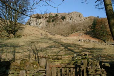
This Lake District walk starts at the carpark at Legburthwaite (GR NY318196) half a mile down the B5322 from its junction with the A591. The carpark is on the west side of the B5322. Opposite the carpark on the east side of the road is a stile which marks the track leading up to Castle Rock.
Take the path up the hill in the direction of Castle Rock until the 'leat' is reached. Turn left along the leat until you come to a second stile which after crossing, gives access to a wooden fence immediately upon your left connecting you to a path which follows the line of the intake wall, upon reaching the second gate above Fornside Farm at the beginning of a small wood head uphill before joining the old Peat Path.
The old peat track zig zags up the rib and makes the steep climb relatively easy. The views south along St Johns in the Vale are good and can only really be seen from this rib.
Beckthorne's Rib reaches the peat moor near a small ruined sheepfold (GR327212). In clear weather, Calfhow Pike (looking like a Dartmoor tor) can be seen quarter of a mile away just south of east. A steadily rising climb with no path leads to the Pike which is a good viewpoint. Clear paths lead from the Pike north to Clough Head and southeast to our next objective Great Dodd. After half a mile the main path reaches the shoulder called Little Dodd and at this point branch left (east) and take a curving path leading to Great Dodd summit cairn after quarter of a mile. A better lunch stop is at a shelter 100 yards to the south east.
From Great Dodd shelter follow a path leading over level ground to Watson's Dodd which is reached after half a mile. Note: On the Dodds ridge it is easy to miss out the summits by accident. On this leg of the walk keep to the west, taking paths to the right when a choice is available. The summit is hardly noticable being a minor pile of stones on a flat moor.
From Watson's Dodd a path heading south east over level ground reaches the summit of Stybarrow Dodd after less than half a mile. Like Watson's Dodd, the summit is hardly noticable. From the summit a path leads south west and then due south and drops down to the summit of Sticks Pass where a small cairn and post mark one of the least impressive passes in the Lakes. Turn right and follow a gradually steepening path which eventually reaches a sheepfold above Stannah Gill. From the sheepfold good views open up of St Johns in the Vale and High Rigg and a steeper path zig zags down the fellside to rejoin the road at the hamlet of Stannah. Turn right onto the B5322 and follow it for half a mile back to the carpark at Legburthwaite.
Other walks nearby
| Walk 2019 | Raven Crag, the Benn & Shoulthwaite Gill near Thirlmere | easy/mod | 4.0 miles |
| Walk 2032 | Great How, a short ascent above Thirlmere | easy | 2.0 miles |
| Walk 1247 | Helvellyn & Raise from Swirls | mod/hard | 7.0 miles |
| Walk 2025 | Helvellyn & Wythburn from Swirls | mod/hard | 8.5 miles |
| Walk 3132 | High Tove & Blea Tarn | moderate | 7.6 miles |
| Walk 2587 | Castlerigg Stone Circle & St John's in the Vale | easy/mod | 8.5 miles |
| Walk 1356 | Walla Crag | easy/mod | 4.5 miles |
| Walk 1108 | Ashness Bridge & Grange Fell | moderate | 9.0 miles |
| Walk 2525 | Standing Crag & Dock Tarn from Watendlath | moderate | 7.0 miles |
| Walk 2526 | Standing Crag, Ullscarf & Borrowdale | mod/hard | 10.0 miles |
Recommended Books & eBooks
Walking the Lake District Fells - Keswick
 Part of the Walking the Lake District Fells series, this guidebook covers a wide range of routes to 30 Lakeland summits that can be climbed from Keswick, Whinlatter, Bassenthwaite, Caldbeck, Mungrisdale and Threlkeld, with highlights including Skiddaw and Blencathra. Includes suggestions for longer ridge routes.
More information
Walking the Lake District Fells - Mardale and the Far East
 Part of the Walking the Lake District Fells series, this guidebook covers a wide range of routes to 36 Lakeland summits that can be climbed from the Ullswater, Haweswater, Troutbeck, Kentmere and Longsleddale valleys, with highlights including High Street, Place Fell and the Kentmere fells. Suggestions for longer ridge routes are also included.
More information
Messaging & Social Media
Message Walking Britain and follow the latest news.

Mountain Weather
Stay safe on the mountains with detailed weather forecasts - for iOS devices or for Android devices.