Castell Carndochan near Bala
Snowdonia/Eryri Walk
Nat Park - Snowdonia - Arans Lake Bala
County/Area - Gwynedd
Author - Ray Hind
Length - 2.5 miles / 4.1 km Ascent - 500 feet / 152 metres
Time - 1 hours 50 minutes Grade - easy/mod
Maps 

| Ordnance Survey Explorer OL18 | Sheet Map | 1:25k | BUY |
| Anquet OS Explorer OL18 | Digital Map | 1:25k | BUY |
| Ordnance Survey Landranger 125 | Sheet Map | 1:50k | BUY |
| Anquet OS Landranger 125 | Digital Map | 1:50k | BUY |
Walk Route Description
Click image to visit gallery of 4 images.
A circular Snowdonia (Eryri) walk to the ruins of Castell Carndochan an early 13th century Welsh castle with views of Lake Bala, Aran ridge, Moel Llyfnant and Arenig Fawr. This is a short walk but it is across open and steep moorland in places. The ground can be wet in places and boots are advised.
Start at the bridge in Dolhendre (SH853308) where car parking is available for 3 cars.
Directions from Bala, take the A494 to Dolgellau, just before Llanuwchllyn, at the 40mph speed limit signs, turn right (to Trawsfynydd) after 2 km you will come to Dolhendre, park next to the phone-box and bridge.
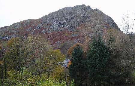
Cross the bridge and continue straight over at the cross-roads. There are good views, to the right, of Castell Carndochan situated on the top of rocky crags.
Continue ahead through a gate into a field (waymarked) and along a track, after 150m bear left to leave the track, passing a building set in trees on your right, then follow the old field boundary, on your right, uphill to cross a stile. Continue in the same direction across a field, uphill towards a house (Ty Coch), continue past the house (on your right) to follow a vehicle track maintaining the same general direction and going uphill. After passing a wood, on your right, turn right to follow the concrete access road to two cottages situated at the foot of Graig ddu. There are good views of the Aran ridge to the left and Lake Bala to the rear.
Go around the cottages, on the right, and climb up a short distance to a path, running behind the cottages. Turn right onto the path and after a short distance cross a stile with an adjacent gate and continue on the path that contours around the hill. There are views of Lake Bala to the right. Continue over the next stile/gate, then go downhill to another stile over a stone wall close to a gate. Cross the stile onto open moorland and follow the path swinging left and uphill. The ruined walls of Castell Carndochan are now clear on the right and the general route is via the main ridge to Castell Carndochan. After around 350m, leave the path to bear right towards a fence while maintaining height and keeping above the bracken. At the fence turn right to pick up a path and follow it a short distance along the fence to an improvised crossing point (no stile) after crossing the fence aim for a rock and the main ridge-line and then the summit while maintaining height.
At the summit you will find the ruins of Castell Carndochan (see information note below) and there are good views of Lake Bala with Berwyns in the distance, Aran ridge, Foel-y-Graig, Craig Llestri, Lliw valley, Moel Llyfnant and Arenig Fawr.
There is a choice of route for the descent: you could retrace your steps, while the adventurous may try a more direct return - but be aware of the rock faces and thick bracken below; however, the route described below is a compromise avoiding the steepest parts and making a pleasant circular walk.
Leave the summit via the main ridge, for a short distance, then locate and follow a faint path to the right and downhill aiming for the forest (Coed Bryn Bras). Follow the path to the top of a fence, which stops in a small gulley, pass the fence and turn right onto an old track, follow the track downhill to a wall then left to pass sheep pens, go through a gate to turn right onto a vehicle track. Follow the track which becomes a tarmac road, with views of Castell Carndochan on your right, to the crossroads (used earlier) then turn left to the start.
Information note: Castell Carndochan is a ruined, early 13 th C. Welsh castle and probably previously a roman fort. Among the ruins can be discerned a typically D-shaped southern tower, a northern round tower, and rectangular central buildings, it was probably built by Llywelyn ap Iorwerth. It is situated on an impressive igneous crag near Dolhendre, about two miles west of Llanuwchllyn. This very strong defensive position is guarded by steep crags on three sides, whilst the south western approach is across rough upland, defended by further crags - Craig y Llestri about half a mile away. No doubt there were defences on this hill before the Norman construction obliterated them. The area was certainly of strategic importance in Roman times.
Other walks nearby
| Walk 3017 | Aran Benllyn & Aran Fawddwy from Llanuwchllyn | mod/hard | 10.0 miles |
| Walk 2302 | Arenig Fawr | moderate | 8.0 miles |
| Walk 2937 | Aran Fawddwy northern approach | mod/hard | 8.4 miles |
| Walk 2811 | Rhobell Fawr and Ddualt from near Rhydymain | moderate | 8.5 miles |
| Walk 1499 | Rhobell Fawr and Dduallt from Llanfachreth | moderate | 12.0 miles |
| Walk 2055 | Moel Emoel from near Bala | moderate | 6.0 miles |
| Walk 2551 | Rhobell Fawr from near Rhydymain | moderate | 5.7 miles |
| Walk 1190 | Aran Fawddwy | mod/hard | 7.5 miles |
| Walk 3055 | Glasgwm | moderate | 4.5 miles |
| Walk 1255 | The Aran Ridge | hard | 11.2 miles |
Recommended Books & eBooks
Great Mountain Days in Snowdonia
 Inspirational guidebook to 40 great mountain day walks and scrambles in Snowdonia. Inspirational routes for all abilities across the National Park with routes up Snowdon and Moel Eilio, the Glyderau, the Carneddau, Eifionydd, Siabod and the Moelwynion, Rhinogydd (the Harlech Dome), Migneint and the Arans and Cadair Idris and the Tarrens.
More information
Snowdonia: 30 Low-level and easy walks - South
 Guidebook describing 30 walks in Snowdonia, Wales. Routes are mostly low level and on clear paths and showcase the region's beautiful scenery and rich history and culture. Part of a 2-volume set, this southern volume includes Trawsfynydd, Bala, Dolgellau, Machynlleth, the Harlech Coast and the valleys of the Mawddach and Dyfi.
More information
Messaging & Social Media
Message Walking Britain and follow the latest news.

Mountain Weather
Stay safe on the mountains with detailed weather forecasts - for iOS devices or for Android devices.