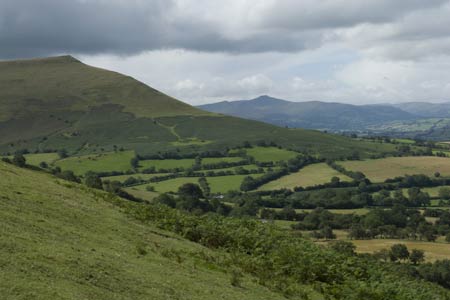
Waun Fach & Y Grib from Pengenfford
Brecon Beacons/Bannau Brycheiniog Walk
Nat Park - Brecon Beacons - Brecon Beacons East
County/Area - Powys
Author - Lou Johnson
Length - 6.5 miles / 10.6 km Ascent - 1700 feet / 515 metres
Time - 5 hours 0 minutes Grade - moderate
Maps 

| Ordnance Survey Explorer OL13 | Sheet Map | 1:25k | BUY |
| Anquet OS Explorer OL13 | Digital Map | 1:25k | BUY |
| Ordnance Survey Landranger 161 | Sheet Map | 1:50k | BUY |
| Anquet OS Landranger 161 | Digital Map | 1:50k | BUY |
Walk Route Description
Click image to visit gallery of 12 images.
This walk onto the Black Mountains of the Brecon Beacons National Park offers superb views across the Wye Valley and some of the mountains to the west including Pen-y-Fan the highest in the national park. The walk is a linear route offering the walker a chance to traverse the fine ridge of Y Grib. Generally the paths are good although some sections can be rather wet underfoot. It is also worth noting that when cloud covers the hills then inexperienced walkers may find navigation problematic.
The start is the small parking area (SO177303) on the narrow lane leading to Dinas Farm off the A479 at Pengenfford. Parking is limited and you may have to use the pub car park on the west side of main road where a small change is payable. Assuming you park in the lane, continue along the lane bearing right up a track enclosed by trees. This can be wet and muddy but do not let this deter you! You emerge from this track faced with an excellent view of the Y Grib ridge. There are a number of options on offer but I feel the best is to take the path that traverses the flank of the ridge. This gains height steadily bringing you out onto the ridge proper at the first col on the ridge (grid ref. SO187308).
Once on the ridge a clear path leads ever upwards with improving views as you climb. There are a couple of rocky sections and you soon reach a large cairn where you might take a break to enjoy the beautiful scenery in this part of Wales. Continuing the climb, do not be persuaded to follow one of the paths lower down on the left hand side of the ridge. Instead follow the crest. This will lead you onto a generally clear path across the moor heading ENE to gain the main ridge (grid ref. SO206314) just west of Pen y Manllwyn.
Turn right onto the main path and continue across the moor towards Waun Fach. Generally the path is good and the wet sections can generally be avoided by using the usual strategies of total avoidance or a fast direct attack. As you near the mound of Waun Fach there is a particularly wet section and this is best avoided by taking an avoiding line well to the left across the rough pathless moor. The summit of Waun Fach offers very little and the summit is rather an anti-climax. The remains of the concrete base of a trig point indicate what might have been the highest point, which is hard to determine. However the views enjoyed getting here are ample reward.
The return route follows the outward route although you may wish to continue the full length of the ridge perhaps adding a visit to the Castell Dinas hill fort as extra interest. This was not the case when this walk was researched as we had rushed down the Y Grib ridge trying to avoid the heavy shower that we had watched approach for well over half an hour. Despite the rush we still managed to get soaked!
Other walks nearby
| Walk 3204 | Hay Bluff & Twmpa | moderate | 10.3 miles |
| Walk 2935 | Llanthony Priory from Capel-y-ffin | easy/mod | 7.7 miles |
| Walk 1238 | Hay Bluff & Twmpa Circular | moderate | 6.0 miles |
| Walk 3546 | Pen y Bryn from Pencelli | moderate | 5.0 miles |
| Walk 3536 | Pen y Bryn & Carn Pica from Pencelli | mod/hard | 11.3 miles |
| Walk 3209 | Llanfrynach and Pencelli circular | easy/mod | 5.6 miles |
| Walk 1237 | Cwmyoy & Hatterrall Hill from Llanthony Priory | moderate | 10.0 miles |
| Walk 3203 | Vale of Ewyas from Llanthony Abbey | moderate | 10.7 miles |
| Walk 3342 | The Hatterall Ridge from Llanthony Priory | very hard | 10.0 miles |
| Walk 1660 | Craswall Priory & Hay Bluff | easy/mod | 6.0 miles |
Recommended Books & eBooks
Walking in Carmarthenshire
 Guidebook to 30 walking routes (2 to 10 miles) in Carmarthenshire, south Wales, including sections of Carmarthenshire Coast Path. Walks for all abilities, including coastal, river, forest and hill walks in Cambrian Mountains, Tywi Valley, Y Mynydd Du (Black Mountains) and Brecon Beacons. Easy access from Bristol, Cardiff and Swansea.
More information
The Cambrian Way
 Guidebook to the Cambrian Way, a challenging three-week mountain trek through Wales from Cardiff to Conwy. The 470km un-waymarked route is presented from south to north. Often sticking to long, beautiful ridgelines, it crosses wild and rugged terrain and visits many of Wales's highest mountains, including Snowdon.
More information
Messaging & Social Media
Message Walking Britain and follow the latest news.

Mountain Weather
Stay safe on the mountains with detailed weather forecasts - for iOS devices or for Android devices.