Holkham Gap and West Beach from Wells-next-the-Sea
Norfolk Walk
County/Area - Norfolk
Author - Lou Johnson
Length - 4.0 miles / 6.5 km Ascent - 150 feet / 45 metres
Time - 2 hours 10 minutes Grade - easy
Maps 

| Ordnance Survey Explorer 251 | Sheet Map | 1:25k | BUY |
| Anquet OS Explorer 251 | Digital Map | 1:25k | BUY |
| Ordnance Survey Landranger 132 | Sheet Map | 1:50k | BUY |
| Anquet OS Landranger 132 | Digital Map | 1:50k | BUY |
Walk Route Description
Click image to visit gallery of 5 images.
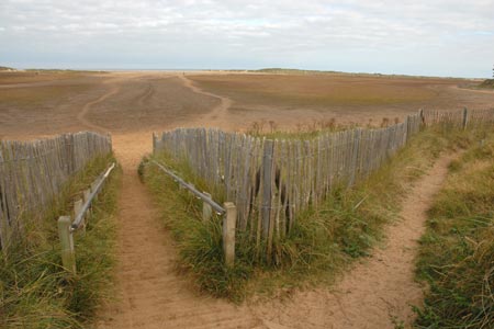
The beach at Wells-next-the-Sea is immense and this walk combines a section of the Norfolk Coast Path with a pleasant walk across West Sands. The size of the beach depends on tides but even at high water the extent of the sands is impressive.
The start is the beach car park (Grid ref. TF914454) with toilets and refreshments in season. This is reached by taking Beach Road from the centre of Wells-next-the-Sea. Alternatively the walk could be started from the centre of the village, which is served by the Hopper bus service. Leave the car park at the western end and follow the signed Norfolk Coast Path. You soon pass the boating lake on your left and then follow the boundary of a conifer plantation on your right. The path leads with any navigational difficulties to Holkham Gap.
Turn right here onto the beach. At low tide you are faced with a vast expanse of sand although even at high tide the sands are still impressive. Bear right and stay on the seaward side of the line of dunes. Walk along the beach to the Coastguard Station and Lifeboat Station at Wells-next-the-Sea. The final section of the walk along the beach is notable for the variety of well-kept beach huts at the back of the beach. Turn right up the steps by the Coastguard Station and then right again into the car park and the end of the walk.
Note - It is worth noting that there is an excellent bus service operating along the A149 coast road between Sheringham and Kings Lynn. Operated by Norfolk County Council, this 'Coast Hopper' service is useful for many walks as the bus route shadows the Norfolk Coast Path. This enables one way walks to be undertaken with relative ease but also means that other walks can be altered to suit your needs.
Other walks nearby
| Walk 3254 | Holkham & Holkham Park Circular | moderate | 10.2 miles |
| Walk 1908 | Wells-next-the-Sea & Holkham Park | easy/mod | 8.0 miles |
| Walk 2101 | Holkham Park circular | easy | 4.5 miles |
| Walk 1035 | Burnham Market | easy | 5.5 miles |
| Walk 1600 | Morston Salt Marshes from Morston Quay | easy | 2.5 miles |
| Walk 2307 | Blakeney from Morston Quay | easy | 2.0 miles |
| Walk 3732 | Morston, Blakeney & Cley next the Sea | easy | 4.0 miles |
| Walk 1804 | Blakeney & Cley next the Sea | easy | 5.0 miles |
| Walk 1730 | Blakeney Point | moderate | 9.0 miles |
| Walk 2401 | Salthouse from Cley-next-the-Sea | easy | 4.0 miles |
Recommended Books & eBooks
No suggestions for this area.Messaging & Social Media
Message Walking Britain and follow the latest news.

Mountain Weather
Stay safe on the mountains with detailed weather forecasts - for iOS devices or for Android devices.