Linley Hill and Linley from The Bog
Shropshire Hills Walk
Region - Shropshire Hills
County/Area - Shropshire
Author - Lou Johnson
Length - 8.5 miles / 13.8 km Ascent - 1600 feet / 485 metres
Time - 5 hours 50 minutes Grade - moderate
Maps 

| Ordnance Survey Explorer 216 | Sheet Map | 1:25k | BUY |
| Anquet OS Explorer 216 | Digital Map | 1:25k | BUY |
| Ordnance Survey Explorer 217 | Sheet Map | 1:25k | BUY |
| Anquet OS Explorer 217 | Digital Map | 1:25k | BUY |
| Ordnance Survey Landranger 137 | Sheet Map | 1:50k | BUY |
| Anquet OS Landranger 137 | Digital Map | 1:50k | BUY |
Walk Route Description
Click image to visit gallery of 6 images.
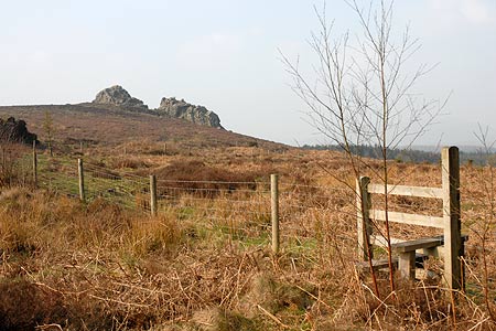
The Stiperstones is a rocky ridge that lies to the west of the Long Mynd. Most walkers concentrate on the highest section that rises to 536 metres with few walkers venturing south as the ridge gradually loses height towards Black Radley Hill. One reason may be the amount of conifer woodland shown on OS maps yet recent years have seen the removal of much of this, particularly on the ridge, in an effort to restore the landscape to its former glory.
The start is the small car park at The Bog (Grid ref. SO357978). From here take the signed path from the eastern side of the car park and continue in a south eastern direction across a meadow. Approaching the top of the field turn right and walk roughly south keeping the conifer plantation on your right. Cross a track (Grid ref XXX) and continue straight ahead onto the cleared ridge with expansive views ahead. Approaching the rock bear left down a rough track to reach a lane (Gid ref. SO354959).
Turn right a short way and then left over a stile to follow the Shropshire Way down into a valley, across a stream and up the other side to a lane. Turn right along the lane and after passing a farm turn right on a signed path that climbs steeply onto Linley Hill. Take care when you near the top and turn right (Grid ref. SO360950) keeping the fence of your left. The path soon becomes a wider track and this followed through an avenue of trees down to a road (Grid ref. SO350934).
Turn right and follow the lane in a north westerly direction bearing left at the first road junction (Grid ref. SO349935). This lane follows the River West Onny which is on your left. Continue along the lane which was lightly trafficked to reach another junction (Grid ref. SO344951). Turn left here and follow the lane into Nind and fork right at the junction (Grid ref. SO333959).
Ignore the signed bridleway veering left and continue ahead reaching a signed path on your right (Grid ref. SO334968). Turn down this path crossing a stream before climbing to a group of cottages. There was some building work in progress here and the waymarkers were missing in April 2007. However turn left behind the cottage on your left to reach a stile with a footpath sign and a track. Follow this track as it goes right and then left round the edge of the field.
Reaching a footpath (Grid ref. SO342972), turn off the track and walk towards the wood. This path is not clear on the ground but leads to a stile into the woods. Go down into the wood to a clearing and turn right. This leads in a northeast direction out of the wood into a field. Bear left and continue in a northeasterly direction to reach a track (Grid ref. SO349978). The OS map in this vicinity does not agree with paths on the ground. The path cutting the corner shown on maps is impenetrable. A lack of use has made this path impossible to follow so it is better to turn left down this track and right at the first junction (Grid ref. SO348981). This leads you back to the start.
Other walks nearby
| Walk 3395 | The Stiperstones Ridge | easy/mod | 5.5 miles |
| Walk 3422 | Ratlinghope & the Stiperstones from the Knolls | moderate | 7.5 miles |
| Walk 3596 | The Stiperstones from the Knolls | easy | 2.0 miles |
| Walk 3045 | The Stiperstones & Blakemoor Flat from the Knolls | easy/mod | 5.0 miles |
| Walk 1072 | Stiperstones low level circular | easy | 4.0 miles |
| Walk 2745 | Betchcott Hills & Pole Bank | moderate | 9.0 miles |
| Walk 1205 | Adstone Hill, Medlicott and the Long Mynd | moderate | 9.5 miles |
| Walk 3529 | Stiperstones from Snailbeach | easy/mod | 7.0 miles |
| Walk 1871 | Snailbeach & the Stiperstones | moderate | 7.0 miles |
| Walk 2814 | Corndon Hill from Priest Weston | easy | 1.5 miles |
Recommended Books & eBooks
Hillwalking in Shropshire
 Guidebook to 32 walking routes in Shropshire in the West Midlands. The routes range from 3 miles (5km) to 12 miles (19km), taking in highlights such as The Wrekin, Wenlock Edge, Long Mynd and Stiperstones, Castle Ring and Bury Ditches. Many routes start near delightful towns and villages including Church Stretton, Ludlow and Bishops Castle.
More information
Messaging & Social Media
Message Walking Britain and follow the latest news.

Mountain Weather
Stay safe on the mountains with detailed weather forecasts - for iOS devices or for Android devices.