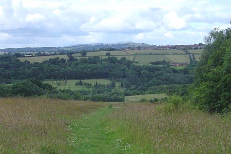
Highley from the Severn Valley Country Park
Shropshire Walk
County/Area - Shropshire
Author - Peter Lane
Length - 4.5 miles / 7.3 km Ascent - 700 feet / 212 metres
Time - 3 hours 0 minutes Grade - easy/mod
Maps 

| Ordnance Survey Explorer 218 | Sheet Map | 1:25k | BUY |
| Anquet OS Explorer 218 | Digital Map | 1:25k | BUY |
| Ordnance Survey Landranger 138 | Sheet Map | 1:50k | BUY |
| Anquet OS Landranger 138 | Digital Map | 1:50k | BUY |
Walk Route Description
Click image to visit gallery of 11 images.
A hilly short walk from the Severn Valley Country Park Visitor Centre visiting the old coal mining town of Highley on the opposite bank of the mighty River Severn and the Severn Valley Railway (SVR). A section of this walk includes the Severn Way recreational path. The Severn Valley Railway is crossed in two places offering the potential sighting of a steam train. The Station at Highley has a visitors' display in an old carriage and there are artefacts of the old mining activities at the Country Park Visitor Centre at the beginning of the walk.
The starting point chosen in this description is the Severn Valley Country Park at Alveley, grid reference SO755841, where there is ample car parking. The route could just as easily be started at the opposite bank of the river in the Highley side of the Country Park at grid reference SO746831. Alternatively as part of a day out on the SVR from Highley Station or Country Park Halt.
From the Visitor Centre car park, retrace slightly and head past the small pond at the easy access nature trail and through a gate heading into a field. Look back across the Severn Valley to the Clee Hills: Titterstone Clee on the left and Brown Clee on the right. At the top of the field, turn left and follow the path around a paddock. Emerge onto a drive and then onto a tarmac lane. Turn left on the lane and then left again into the Alveley Industrial Estate. Head downhill through the estate until the road enters the Severn Valley Country Park once more. Descend to the new bridge spanning the River Severn. Cross and enjoy the wonderful views up and downstream.
Having crossed the bridge turn right and follow the sign to Country Park Halt. Here cross the line (watch out for trains) and head up a steep enclosed footpath. Coming to a gate, turn left and continue to The Old Coach House, where there is a footpath leading off to the left. Follow this as it opens up into a track and eventually a road. Turn right up the road and enter Highley. The road starts to go downhill at some terraced houses and meets the High Street. Turn left along the High Street for a hundred metres or so and then look for Birdcage Walk on the right. Follow this to the Church.
Walk into the churchyard and return to the main road via the churchyard. Turn right along the main road and then left down Station Road. Coming to the entrance to the Severn Valley Country Park (other side of the river from the start point now), enter the car park and walk through into the park itself. Soon on the right you will find the winding wheel from the old colliery and a narrow gauge carriage turned into a planter as a memorial to the heyday of mining at Highley.
Descend through the park and follow the signs down to the SVR station. The station itself is usually a hive of activity with its beautifully kept building, signal box, exhibition and frequent special events. After exploring the station, descend the footpath in line with the crossing point down to the River Severn. Now follow the Severn Way upstream all the way back to the bridge at Alveley.
After crossing the river, walk up to the Visitor Centre (sign-posted) or explore the park at your leisure. The Centre is a good place to find local tourist information, see some of Highley's mining heritage or just stop for refreshments.
Other walks nearby
| Walk 3504 | Highley to Bewdley along the River Severn | easy/mod | 7.0 miles |
| Walk 2807 | The River Severn from Hampton Loade to Bridgnorth | easy/mod | 6.0 miles |
| Walk 1933 | Wyre Forest & River Severn from Upper Arley | easy/mod | 7.6 miles |
| Walk 1451 | Dudmaston Estate circular | easy | 4.0 miles |
| Walk 2466 | The Severn Valley from Trimpley Reservoir | easy | 6.0 miles |
| Walk 2288 | Pound Green and Dowles Brook from Hawkbatch | easy | 5.0 miles |
| Walk 2874 | Enville Estate and the Sheepwalks | easy | 4.0 miles |
| Walk 1603 | Shatterford Wood and Castle Hill circular | easy/mod | 5.5 miles |
| Walk 2131 | Wyre Forest National Nature Reserve, Bewdley | easy | 3.3 miles |
| Walk 3003 | Kinver Edge & Blakeshall from Holy Austin Rock | easy | 4.3 miles |
Recommended Books & eBooks
Hillwalking in Shropshire
 Guidebook to 32 walking routes in Shropshire in the West Midlands. The routes range from 3 miles (5km) to 12 miles (19km), taking in highlights such as The Wrekin, Wenlock Edge, Long Mynd and Stiperstones, Castle Ring and Bury Ditches. Many routes start near delightful towns and villages including Church Stretton, Ludlow and Bishops Castle.
More information
Messaging & Social Media
Message Walking Britain and follow the latest news.

Mountain Weather
Stay safe on the mountains with detailed weather forecasts - for iOS devices or for Android devices.