Stafford - a town centre stroll
Staffordshire Walk
County/Area - Staffordshire - Mid Staffordshire
Author - Lou Johnson
Length - 1.5 miles / 2.4 km Ascent - 30 feet / 9 metres
Time - 0 hours 50 minutes Grade - easy
Maps 

| Ordnance Survey Explorer 244 | Sheet Map | 1:25k | BUY |
| Anquet OS Explorer 244 | Digital Map | 1:25k | BUY |
| Ordnance Survey Landranger 127 | Sheet Map | 1:50k | BUY |
| Anquet OS Landranger 127 | Digital Map | 1:50k | BUY |
Walk Route Description
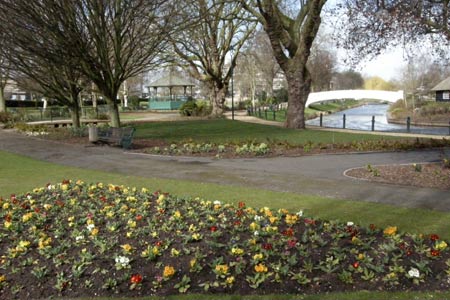
Click image to visit gallery of 3 images.
This short stroll explores Stafford town centre. The County town of Staffordshire is dominated by many buildings associated with local government. The route is easy to follow and provides a tour that includes the key buildings in the town as well as a section of the path alongside the River Sow.
The route starts from Stafford Railway Station (grid ref. SJ918229), which is signed from all major roads into the town. Parking at the station is not cheap and you may opt to park on the street nearby or at the large pay and display car park at Sainsbury's supermarket (see route description).
Cross the pedestrian crossing immediately in front of the station and go straight ahead through a gate into Stafford Park. Always well maintained, the park is a haven of green within the town. Bear right past the cast-iron shelter and make for the white concrete bridge across the River Sow, which joins the River Trent about 6 miles to the east. Cross the bridge and bear right, keeping the bowling green on your left. This leads you past an aviary to exit the park.
Cross the road using the pelican crossing and walk straight ahead. Walk past the small car park, modern shops and pub on your left to reach Mill Street, one of the streets that still retains some character. On the opposite side of the road is a small half timbered building. Walk up the narrow road to its left (Church Lane) which also retains some visually interesting buildings. At the top of the lane, just past the 'Soup Kitchen', you reach an open green space in front of St Mary's Church.
The route turns right here but it is worth walking a few yards ahead to inspect the foundations of St Bertelin's Chapel, which is the oldest part of St Mary's church. Continuing with St Mary's on your left you reach the High Street. Immediately on your right is the Ancient High House, the largest surviving Tudor half timbered house in the UK. Recently the subject of restoration, the house now contains a small museum.
The walk continues by turning left up the High Street but first there is a short diversion across the street to see St Chad's Church. This is the oldest building in Stafford with roots in the 12th century. Sadly the church is somewhat overshadowed by more recent buildings but still retains its unique heritage.
Walking north along the High Street you soon reach the Market Square. The Shire Hall dominates the square. Built in 1798 as a court house and office of the Mayor and Clerk of Stafford, the Shire Hall is now used as an art gallery and library. In addition the court rooms have been preserved and can be visited.
Continue north along the pedestrianised High Street to reach Gaol Square. Do not cross any roads here but bear left and follow the pavement as far as the first crossing opposite Sainsbury's. Cross the road here, bearing left immediately in front of the supermarket. This footpath leads across the River Sow. Where the footpath splits on the other side of the river, bear left to reach a pedestrian crossing. Cross this crossing and continue across the car park on a succession of crossings, bearing right on the other side between walls to exit onto Doxey Road.
Cross the road using the crossing. Once on the other side, continue along the riverside path. This leads you beside the River Sow under a low bridge into the park. Of interest on this section is the statue to Izaak Walton (born in Stafford) who wrote 'The Compleat Angler' in 1653. Once the park is reached bear right past the shelter to reach the station.
Other walks nearby
| Walk 3591 | Derrington circular from Stafford Castle | easy | 3.6 miles |
| Walk 1394 | Bednall & Acton Trussell from near Stafford | easy | 6.5 miles |
| Walk 2443 | Tixall from St Thomas Priory near Stafford | easy | 7.0 miles |
| Walk 2199 | Brocton & Walton-on-the-Hill Circular | easy | 3.5 miles |
| Walk 1802 | Shugborough Park from Milford | easy | 4.5 miles |
| Walk 1189 | Cannock Chase Circular | easy | 6.5 miles |
| Walk 2911 | Seven Springs, Little Haywood, Shugborough & Milford | easy | 6.5 miles |
| Walk 2111 | Milford, Seven Springs, Little Haywood & Shugborough | easy | 6.0 miles |
| Walk 2842 | Sandon Park from Salt | easy | 4.6 miles |
| Walk 1370 | Sherbrook Valley from Punch Bowl, Milford | easy | 4.0 miles |
Recommended Books & eBooks
Walking in the Peak District - White Peak East
 Guidebook describing 42 half-day and day walks in the limestone landscapes of Derbyshire's White Peak, part of the Peak District National Park. One of two volumes, this book covers the east of the region, with potential bases including Bakewell, Eyam, Castleton, Birchover, Matlock and Wirksworth.
More information
Messaging & Social Media
Message Walking Britain and follow the latest news.

Mountain Weather
Stay safe on the mountains with detailed weather forecasts - for iOS devices or for Android devices.