Grindon & the Manifold Way from Waterhouses
Peak District Walk
Nat Park - Peak District - Dovedale Manifold Valley
County/Area - Staffordshire
Author - Lou Johnson
Length - 8.0 miles / 13 km Ascent - 1200 feet / 364 metres
Time - 5 hours 10 minutes Grade - moderate
Maps 

| Ordnance Survey Explorer OL24 | Sheet Map | 1:25k | BUY |
| Anquet OS Explorer OL24 | Digital Map | 1:25k | BUY |
| Ordnance Survey Landranger 119 | Sheet Map | 1:50k | BUY |
| Anquet OS Landranger 119 | Digital Map | 1:50k | BUY |
Walk Route Description
Click image to visit gallery of 12 images.
This Peak District walk combines field paths, quiet lanes and the Manifold Way to explore the Staffordshire countryside in the southern sector of the National Park. Limestone is the predominant rock but in the distance you can see the gritstone hills of the Staffordshire Moorland. The geology goes a long way to explaining why the River Hamps (followed on the return part of the route) is usually dry. The pictures were taken after a particularly wet July (2007) so the water in the river is remarkably high and running at very unusual levels.
The start is the small pay and display car park adjacent to the Cycle Hire (Grid ref. SK085501) centre in Waterhouses. This is accessed via a tarmac drive on the south side of the disused railway bridge over the road to Cauldon Low. After parking walk back down the approach drive and veer right down the access path to reach the main road. Turn left towards Leek along the A523. After approximately 100 metres, take the signed footpath on the north side of the road (Grid ref. SK083502). This leads across fields to reach Rocester Lane. Turn left and walk towards Waterfall. After just over 100 metres, take the signed path on your left and cross field to reach the road in the village of Waterfall.
Take the drive leading north between houses from the main road junction. The drive leads into a footpath, which soon passes the church. Just past church bear slightly left and continue on the path, descending to a footbridge and a lane (Grid ref. SK081519). Cross over and go slightly left to locate a dilapidated stile and a half hidden sign. Cross this stile and follow the farm track into the farm yard. Immediately after entering the yard, turn left and go through the gate and walk uphill with the field boundary to your immediate left. This leads to Slade Lane.
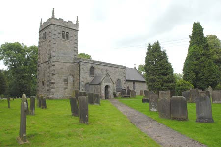
Turn left on this one time an important pack-horse route to reach Oldfields Farm. Go through the yard and continue along the metalled access road past Deepdale Farm towards the village of Grindon with an impressive church and tall spire. At the first road junction (Grid ref. SK885542) turn right towards Weag's Bridge and Wetton. You could spend a few minutes exploring the village and its church, after which you should return to this junction to continue the walk. Follow the lane towards the Manifold Valley as far as a sharp left hand bend (Grid ref. SK097539). Here you leave the road and take the bridle path that goes straight on. This descends to reach light woodland before reaching the Manifold Way on the valley floor.
Turn right along the Manifold Way, which is shared by walkers, horse-riders and cyclists. Originally the trackbed of the narrow-gauge Leek and Manfold Light Railway, the route lay abandoned for many years after the closure of the railway between the Wars. Following the normally dry bed of the Hamps, the surfaced trail climbs gently back to the main A523 near Waterhouses. The trail follows the valley, which is wooded for the first section but eventually becomes flanked by hillside pastures. Reaching the main road, turn right and continue towards the centre of Waterhouses. On your left you will reach a path leading between metal barriers back to the car park.
Other walks nearby
| Walk 3455 | Manifold Valley & Dovedale om Ilam | moderate | 9.5 miles |
| Walk 3527 | Dovedale and Manifold Valley from Ilam | moderate | 7.5 miles |
| Walk 1475 | Bunster Hill and Dovedale from Ilam | easy/mod | 4.5 miles |
| Walk 2259 | Ilam | easy | 4.5 miles |
| Walk 3562 | The Weaver Hills from Wootton | easy | 3.2 miles |
| Walk 1181 | Wetton Hill & the Manifold Valley | easy/mod | 6.5 miles |
| Walk 1653 | The Manifold Valley from Wetton | easy/mod | 7.8 miles |
| Walk 2681 | Wetton & Manifold Valley from Wetton | easy/mod | 3.6 miles |
| Walk 2537 | Ecton Hill & Wetton from Wetton Mill | moderate | 7.0 miles |
| Walk 1195 | High-level Dovedale | moderate | 9.5 miles |
Recommended Books & eBooks
Great Mountain Days in the Pennines
 An inspirational guidebook to 50 classic walks on the rolling Pennine landscape. The graded routes, between 6 and 13 miles in length, cover classic Pennine fells and moorland such as Whernside, Ilkley Moor and Pendle Hill; exploring the North and South Pennines, Yorkshire Dales, Howgills and Dark Peak. Many routes are also suited to fell running.
More information
Walking in the Peak District - White Peak East
 Guidebook describing 42 half-day and day walks in the limestone landscapes of Derbyshire's White Peak, part of the Peak District National Park. One of two volumes, this book covers the east of the region, with potential bases including Bakewell, Eyam, Castleton, Birchover, Matlock and Wirksworth.
More information
Messaging & Social Media
Message Walking Britain and follow the latest news.

Mountain Weather
Stay safe on the mountains with detailed weather forecasts - for iOS devices or for Android devices.