Ilmington Down
Cotswolds Walk
Region - Cotswolds
County/Area - Warwickshire
Author - Lou Johnson
Length - 4.3 miles / 6.9 km Ascent - 680 feet / 206 metres
Time - 2 hours 50 minutes Grade - easy/mod
Maps 

| Ordnance Survey Explorer 205 | Sheet Map | 1:25k | BUY |
| Anquet OS Explorer 205 | Digital Map | 1:25k | BUY |
| Ordnance Survey Landranger 151 | Sheet Map | 1:50k | BUY |
| Anquet OS Landranger 151 | Digital Map | 1:50k | BUY |
Walk Route Description
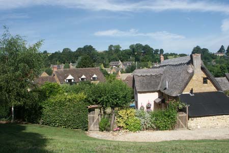
Click image to see photo description.
This walk explores the highest ground in Warwickshire, which is located in the Cotswolds Area of Outstanding Natural Beauty and forms the northernmost section of this range of hills. Starting in the attractive village of Ilmington, the route uses a mixture of footpaths, bridleways and country lanes to explore Ilmington Down and the immediate surroundings. The views are generally good with those from the top of the Down to the west over the Vale of Evesham particularly noteworthy.
The walk starts in the village of Ilmington where limited parking is available around the village green in front of the Village Shop, which was formerly the Roman Catholic Church (Grid ref. SP210433). Take the lane immediately in front of this Church and follow it southwest between houses and cottages. Gaining height the lane reaches a large gate (Grid ref. SP206429). Do not go through this, instead turn right through a smaller metal gate and then almost immediately left through another gate onto a footpath. This path climbs through fields with a boundary fence on your left.
Reaching Pig Lane (Grid ref. SP204425), turn right and follow this undulating bridleway past the radio antenna to reach a road. Go straight across and climb slightly to reach the top of Ilminster Down and the highest point in Warwickshire. Turn right (Grid ref SP187426) down the tarmac lane. Ignore the first bridleway on your right which would take you back to the antenna and continue down the lane for approximately one kilometre to reach a second marked bridleway across a field. This leads you around Upper Lark Stoke and through rolling countryside to reach a road (Grid ref. SP204432).
You can walk down the road back into Ilmington but a preferable option is to follow the footpath that leaves the bridleway on your left just before reaching the road. At the first path junction go left over a stile and continue across the next field. Cross the next stile and turn right down a wide grassy track between hedges. This leads you down to gates marked as no right of way. Go left through a gate and then down a narrow enclosed path which you leads down to a road. Opposite is the Parish Church in Ilmington. Cross the road and take the path to the right of the churchyard. At the first path junction, bear right and this will lead you to a road. If you require refreshments then there is a pub in the village and this can be reached by turning left and walking a few hundred metres with pub on your left, otherwise your car will be parked opposite by the village green.
Other walks nearby
| Walk 3212 | Ebrington & Foxcote circular | easy | 3.7 miles |
| Walk 2541 | Hidcote & Foxcote from Mickleton | easy/mod | 7.5 miles |
| Walk 1749 | Upper Quinton & Hidcote Bartrim from Mickleton | easy/mod | 6.8 miles |
| Walk 3665 | Honington & Idlicote Circular | easy/mod | 6.0 miles |
| Walk 1308 | Broadway & Chipping Campden | moderate | 11.0 miles |
| Walk 1359 | Stratford-upon-Avon from Milcote | easy/mod | 7.0 miles |
| Walk 2489 | Upper Brailes Circular | easy/mod | 5.6 miles |
| Walk 2673 | Stratford-upon-Avon circular | easy | 3.8 miles |
| Walk 3734 | Compton Verney Circular | easy/mod | 7.2 miles |
| Walk 3072 | Broadway, Stanton & Laverton | easy/mod | 7.5 miles |
Recommended Books & eBooks
The Cotswold Way Map Booklet
 Map of the 102 mile (163km) Cotswold Way National Trail, between Chipping Camden and Bath. This booklet is included with the Cicerone guidebook to the trail, and shows the full route on OS 1:25,000 maps. The trail typically takes two weeks to walk, and is suitable for walkers at all levels of experience.
More information
The Cotswold Way
 Guidebook to walking the Cotswold Way National Trail. Between Chipping Campden and Bath, the 102 mile route explores the Cotswolds AONB. Described in both directions over 13 stages, the Cotswold Way can be walked year round and is suitable for beginner trekkers. Includes separate OS 1:25,000 map booklet of the route.
More information
Messaging & Social Media
Message Walking Britain and follow the latest news.

Mountain Weather
Stay safe on the mountains with detailed weather forecasts - for iOS devices or for Android devices.