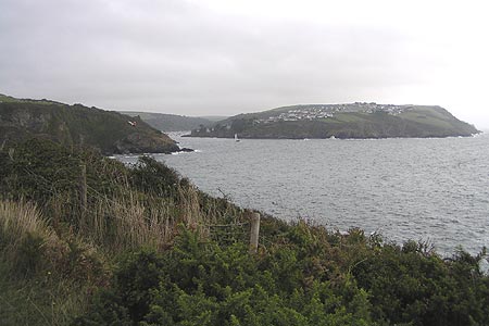
Gribbin Head & Polkerris from Polruan
Cornwall AONB Walk
Region - Cornwall AONB
County/Area - Cornwall
Author - Paul Deane
Length - 8.5 miles / 13.8 km Ascent - 2050 feet / 621 metres
Time - 6 hours 20 minutes Grade - moderate
Maps 

| Ordnance Survey Explorer 107 | Sheet Map | 1:25k | BUY |
| Anquet OS Explorer 107 | Digital Map | 1:25k | BUY |
| Ordnance Survey Landranger 204 | Sheet Map | 1:50k | BUY |
| Anquet OS Landranger 204 | Digital Map | 1:50k | BUY |
Walk Route Description
Click image to visit gallery of 3 images.
Fowey has to be one of the most beautiful towns in Engalnd. It sits on the West bank of the River Fowey overlooking the natural harbour formed by the river and the Polruan Headland. Nowadays the harbour is mainly used by pleasure craft although large commercial ships still travel upriver to load cargoes of china clay. The local countryside is typical of south Cornwall. The hills are not as high as the north of the county and the coastline is less rugged.
We started our Cornwall walk from the Polruan side of the estuary because we thought that it would be fun to begin our walk with a ferry crossing. It is, however more practical, if less interesting, to start in Fowey. The walk begins at the car park in Polruan (Grid ref. SX131 507) Turn left out of the car park and follow Fore Street all the way down the steep bank to the bottom. When the road levels out you will see the ferry quay in front of you.
After a brief crossing the ferry will deposit you at the quay on the West bank (Grid ref. SX123514). Walk up the quay, past the ferry's shelter, then turn right up the bank. When you reach the road turn left and head south west along Esplanade and on to Tower Park. Where the road forks bear left along Readymoney Road and walk downhill to the wonderfully named Readymoney Cove (derived, mundanely enough, from the Cornish Redeman meaning pebbly). At the bottom you will find a coast path fingerpost that directs you south east through the woods the out on to Allday's Fields.
Follow the coast path as it trends south west to Southground Point and then round the corner into Polridmouth. It's quite a surprise to leave the trees and the coastal farmland to enter private grounds with manicured lawns and lakes that are situated at the head of the inlet. From Polridmouth follow the coast path SSW up a steep, grassy bank to the Gribbin Tower (Grid ref. SX098497). The tower was built in 1832 as a daylight navigation aid for shipping. Prior to this Gribbin Head had been frequently mistaken for St Anthony's Head near the port of Falmouth - a dangerous mistake on such an unforgiving coastline. From the tower the path heads west north west, skirting a wood and entering heathland and farmland before turning north all the way to Polkerris. This section is typical of the SWCP; the clearly defined path cuts through dense 4ft bracken and blackthorn, right next to the sea. Perfect.
Near Polkerris the path ascends and to you left you'll see a steep wooded area with the coast path zig-zagging down it. We followed the path downwards for a break at the Rashleigh Inn on the sea front at Polkerris. However, the walk route heads east, along the track, to the road. Turn right at the road and follow it for about 100m until you see a fingerpost indicating the Saints' Way.
Walk Northeast down the track to the farm and follow the farmer's (very clear!) directions to leave his land over the footbridge. From here the route heads East over gently undulating farmland until it reaches the woods (Grid ref. SX107518). The wood closes in on the path as it slopes downwards to a bridge that carries a stream overhead. From here it's a short walk south east to the road. Turn right on to the road and walk southwards past the Lankelly-Fowey RFC, before turning left in to Rashleigh Lane. 300 metres along Rashleigh Lane turn right in to Love Lane, following Saints' Way signposts. The track enters a wood and slopes downward, becoming rocky and slippery, before emerging at Readymoney Cove. From here it's a simple matter of retracing your steps back to your starting point.
Other walks nearby
| Walk 1031 | Polruan & Lanteglos Church | easy/mod | 4.3 miles |
| Walk 1030 | Fowey & Gribbin Head | moderate | 8.0 miles |
| Walk 3112 | Soar Mill Cove & Bolt Head from Higher Soar | easy/mod | 6.5 miles |
| Walk 1783 | Gorran Haven & Dodman Point | easy/mod | 5.0 miles |
| Walk 3606 | Berry Down from St Neot | easy/mod | 5.6 miles |
| Walk 1033 | Dodman Point & Gorran Haven | mod/hard | 11.0 miles |
| Walk 2247 | Draynes Bridge & Siblyback Lake | easy/mod | 5.0 miles |
| Walk 1027 | Nare Head & Portloe | moderate | 7.0 miles |
| Walk 1883 | Advent Church | easy | 5.2 miles |
| Walk 3589 | Padstow from Little Petherick | easy | 5.0 miles |
Recommended Books & eBooks
Walking in Cornwall
 This guidebook includes routes to 40 day walks in Cornwall. From short, easy strolls to longer, wilder routes, there is plenty to appeal to both families and experienced walkers. The walks explore the interior and coasts, including walks through picturesque villages, old tin-mining areas and the Lizard and Land's End Peninsulas.
More information
Messaging & Social Media
Message Walking Britain and follow the latest news.

Mountain Weather
Stay safe on the mountains with detailed weather forecasts - for iOS devices or for Android devices.