Forth & Clyde Canal & Antonine Wall
North Lanarkshire Walk
County/Area - North Lanarkshire & East Dunbartonshire
Author - Rob Kay
Length - 6.0 miles / 9.8 km Ascent - 720 feet / 218 metres
Time - 3 hours 40 minutes Grade - easy
Maps 

| Ordnance Survey Explorer 349 | Sheet Map | 1:25k | BUY |
| Anquet OS Explorer 349 | Digital Map | 1:25k | BUY |
| Ordnance Survey Landranger 64 | Sheet Map | 1:50k | BUY |
| Anquet OS Landranger 64 | Digital Map | 1:50k | BUY |
Walk Route Description
Click image to visit gallery of 5 images.
A circular, low-level route taking in some of the best sections of both the Forth & Clyde canal and the Roman Antonine Wall.
The walk starts at Auchinstarry Marina (grid ref. NS719769), a haven for many small craft, and proceeds along the canal towpath in an easterly direction for a mile and a half to Craigmarloch (Grid ref. NS737774). Turn right over the bridge and continue uphill towards Condorrat on the minor road for a couple of hundred yards then climbing steadily, follow the signs to the Antonine Wall and continue along the ridge to Croy for a couple of miles, with superb views over the Kilsyth Hills to the north. The Antonine Wall is clearly visible to your right as a deep ditch and embankment.
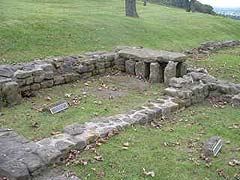
Past Croy, cross the main road and continue along the good path to Barr Hill for a mile, where you can view the excavated ruins of an excellent Roman fort with bath-house and underfloor heating. Continue downhill to Twechar - the excellent local pub offers liquid refreshment but no food. At Twechar turn right down to the canal swing bridge, turn right, and proceed along the canal for a mile or two back to Auchinstarry. A pub and hotel complex is being built and will offer food and accommodation from early 2007.
Other walks nearby
| Walk 2552 | West Highland Way Experience | moderate | 95.0 miles |
| Walk 1490 | West Highland Way - A personal experience | moderate | 96.0 miles |
| Walk 1491 | WHW - Day 1 - Milngavie to Drymen | moderate | 12.0 miles |
| Walk 1557 | The Falkirk Wheel and the Kelpies | easy/mod | 8.0 miles |
| Walk 2709 | Dumyat Hill | easy/mod | 4.5 miles |
| Walk 1492 | WHW - Day 2 - Dryden to Rowardennan | moderate | 15.0 miles |
| Walk 1979 | Culross Heritage | easy | 1.5 miles |
| Walk 2222 | Ben Cleuch from Tillicoultry | moderate | 7.0 miles |
| Walk 2347 | Duncryne from Gartocharn | easy | 2.0 miles |
| Walk 3647 | Callander, Samson's Stone & Coilhallan Wood | easy | 4.7 miles |
Recommended Books & eBooks
No suggestions for this area.Messaging & Social Media
Message Walking Britain and follow the latest news.

Mountain Weather
Stay safe on the mountains with detailed weather forecasts - for iOS devices or for Android devices.