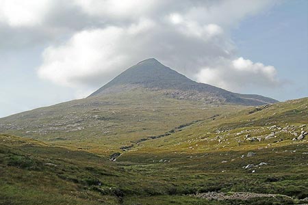
An Cliseam, Isle of Harris
Outer Hebrides Walk
County/Area - Outer Hebrides
Author - Andy Smith
Length - 3.0 miles / 4.9 km Ascent - 2000 feet / 606 metres
Time - 3 hours 30 minutes Grade - moderate
Maps 

| Ordnance Survey Explorer 456 | Sheet Map | 1:25k | BUY |
| Anquet OS Explorer 456 | Digital Map | 1:25k | BUY |
| Ordnance Survey Landranger 14 | Sheet Map | 1:50k | BUY |
| Anquet OS Landranger 14 | Digital Map | 1:50k | BUY |
Walk Route Description
Click image to visit gallery of 3 images.
The mountainous Isle of Harris offers a real challenge to walkers visiting the Outer Hebrides, the landscape is very lunar and a long way from civilisation. Navigational skills here are paramount as very few areas contain pathways or markers of any description. If you stray off course in this wilderness it's unlikely you will be found!
The main issue with all mountains on Harris is the unbroken wind coming off the Atlantic from the west. This can easily reach speeds of 100mph at times, and can be very daunting to an inexperienced walker; this should be taken into consideration before attempting this climb.
An Cliseam is the highest of the Corbets on Harris, and also the highest in the whole island range. The fastest way onto the summit starts from the A859, which is the only road-heading north to south though the island. There is a lay-by (northbound) at NB174057 here there is plenty of parking although don't expect to be alone.
Leave the layby with the river to the right of you. Follow the river for approximately half a kilometre until it splits in two. Here choose the best option and cross the river leaving you in between both waters. The best option from here is to aim straight up the slope heading northwest. This is extremely hard going and as you reach higher levels expect to be using hands as well. Around three quarters of the way to the summit there is a craggy section at grid ref. NB158072. Here you need to bear left with the crags to your right making note of their location as they disappear once you are above them. To descend over these would be treacherous.
The final reach for the summit seems to last forever as you cross a large boulder field. The wind at this point can be awesome as you haul yourself over the rocks keeping low so as not to be blown over! The summit cairn cannot be seen until the last minute as it has a large stonewall built around it, presumably to protect it from the elements! Here on a rare cloud-free day you can expect to see views west out to Loch a Siar, the Isle of Taransay and even St Kilda 44 miles away.
From An Cliseam's summit, the expert walker can decide whether to do a traverse along the ridge taking in Mulla Fo Dheas and back down the faint path to Bun Abhainn Eadarra. For the purposes of this walk description simply re-trace your footsteps back down to the lay-by taking care near the crags at grid ref. NB158072. Reaching the lay-by, it is a satisfying thought to have climbed a great mountain on Harris in one morning.
Other walks nearby
| Walk 1621 | Urgha Beag Circular from near Tarbert | moderate | 11.8 miles |
| Walk 1566 | Isle of Scalpay circular, Harris | easy | 5.3 miles |
| Walk 1165 | The Quirang | easy | 3.2 miles |
| Walk 2806 | Udal & Aird a' Mhorain Point from Greinetobht | easy/mod | 6.5 miles |
| Walk 1164 | The Storr Sanctuary | easy/mod | 3.2 miles |
| Walk 2640 | The Storr & Old Man of Storr from Loch Leathan | moderate | 5.5 miles |
| Walk 1890 | The Butt of Lewis from Eoropie | easy | 3.8 miles |
| Walk 2002 | Dun Caan, Isle of Raasay | moderate | 10.6 miles |
| Walk 2589 | Marsco from the Sligachan Hotel, Isle of Skye | moderate | 8.7 miles |
| Walk 3760 | Glamaig (Sgurr Mhairi & An Coileach) | mod/hard | 4.5 miles |
Recommended Books & eBooks
No suggestions for this area.Messaging & Social Media
Message Walking Britain and follow the latest news.

Mountain Weather
Stay safe on the mountains with detailed weather forecasts - for iOS devices or for Android devices.