Struie circular
Highland Walk
County/Area - Highland - Central Highland
Author - Tony Johnstone
Length - 4.5 miles / 7.3 km Ascent - 1100 feet / 333 metres
Time - 3 hours 20 minutes Grade - easy/mod
Maps 

| Ordnance Survey Explorer 438 | Sheet Map | 1:25k | BUY |
| Anquet OS Explorer 438 | Digital Map | 1:25k | BUY |
| Ordnance Survey Landranger 21 | Sheet Map | 1:50k | BUY |
| Anquet OS Landranger 21 | Digital Map | 1:50k | BUY |
Walk Route Description
Click image to see photo description.
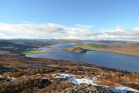
One of the most rewarding walks in Ross-shire is this pleasant ridge walk to Struie Hill which provides walkers with excellent views. The undulating route along the ridge offers a memorable panorama of Dornoch Forth as well as more distant views to many hills some 50 miles distant.
The start is a small car park (grid ref. NH650850) on the B9176 south-east from Ardgay. To reach the start leave Ardgay on the A836. After five kilometres, fork right onto the B9176 and continue uphill to pass the famous Struie Viewpoint. Beyond the viewpoint the road sweeps right and starts to descend. The car park is on your right.
After parking, cross the road and walk uphill for about 100 metres and turn right onto a path that can be seen heading up the hillside towards some trees. The path keeps to the left of the trees and continue uphill to reach the cairn on Struie's summit (grid ref. NH658850) from where the views open out especially to the west with Dornoch Forth dominating the scene.
The walk continues north-east along the ridge following a path that keeps to the highest ground. There are several small summits along the way. Struie Hill with its mast can be seen ahead and this is the final objective of the walk. The summit is slightly lower then Struie and there is also a cairn.
In fine weather with good visibility the view north includes Bienn Spoinnadh (77km to the Northwest), Foinaven, Ben Hope plus many more peaks that are well-spaced across the panorama which helps with identification. The return route follows the outward path. If you have time, there is a hut circle close to the road which is worth exploring.
Other walks nearby
| Walk 3101 | Ben Bhraggie traverse | easy/mod | 4.7 miles |
| Walk 1791 | Tarbat Ness from Porthmahomack | moderate | 9.0 miles |
| Walk 1773 | Ben Wyvis (western approach) | mod/hard | 8.0 miles |
| Walk 1530 | Little Wyvis ascent from near Garve | moderate | 6.4 miles |
| Walk 2106 | Ullapool - a Munro Quartet including Beinn Dearg | very hard | 16.0 miles |
| Walk 1319 | The Bone Caves of Inchnadamph | easy | 3.0 miles |
| Walk 2274 | Cul Mor from Knockan Crag | mod/hard | 8.5 miles |
| Walk 3272 | Conival & Ben More Assynt from Inchnadamph | hard | 11.0 miles |
| Walk 1317 | Sail Gharbh (Quinag) | moderate | 5.4 miles |
| Walk 1018 | Beinn Ghobhlach | moderate | 6.0 miles |
Recommended Books & eBooks
Walking the Munros Vol 2 - Northern Highlands and the Cairngorms
 Guidebook to walking the northern Munros, covering the northern Highlands, the Cairngorms and the Isle of Skye. 70 routes are described, including those up Ben Macdui, Braeriach and Cairn Gorm. Routes range from 7 to 46km, requiring a fair level of fitness. The second of two guidebooks to walking Scotland's Munros: peaks higher than 3000ft.
More information
Great Mountain Days in Scotland
 Inspirational guidebook to 50 challenging routes for mountaineers, scramblers, hillwalkers and fell runners, many long enough to backpack over 2 days, especially in winter (12 to 25 miles). A mix of classic routes and unsung gems across Scotland from Galloway to the Outer Hebrides in widely differing wild landscapes. With customised OS mapping.
More information
Messaging & Social Media
Message Walking Britain and follow the latest news.

Mountain Weather
Stay safe on the mountains with detailed weather forecasts - for iOS devices or for Android devices.