Dunsop Fell & the Forest of Bowland
Forest of Bowland Walk
Region - Forest of Bowland
County/Area - Lancashire
Author - Mike Bexley
Length - 10.0 miles / 16.3 km Ascent - 1420 feet / 430 metres
Time - 6 hours 30 minutes Grade - moderate
Maps 

| Ordnance Survey Explorer OL41 | Sheet Map | 1:25k | BUY |
| Anquet OS Explorer OL41 | Digital Map | 1:25k | BUY |
| Ordnance Survey Landranger 103 | Sheet Map | 1:50k | BUY |
| Anquet OS Landranger 103 | Digital Map | 1:50k | BUY |
Walk Route Description
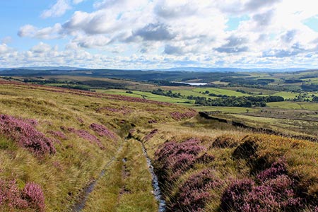
Click image to see photo description.
This is a beautiful walk so do not let the distance put you off as the walk back from the furthest point is easy. One word of warning - do not attempt this walk if the hills are in cloud unless you are confident at map reading and compass work. Like all moorland it is easy to get lost if you lack these skills.
The walk starts at Dunsop Bridge (Grid ref SD661501) where there are toilets. Exit the car park (passing the toilet block) and cross over the road to the Telephone Box. Here you will discover Dunsop Bridge is the centre of The British Isles and that this phone box has a special number. Walk up the road over the river bridge and take the second road on the right past some Forestry Commission cottages on the left. This private road wanders down to the river.
Cross over the bridge and look for some steps up the steep bank on the left. Climb these and then continue straight on over the fields to Beatrix. Here you will join a narrow road. Turn left and follow the road to its end at 'Back of Hill Barn' where you need to locate the foot path going northeast. Follow this path over the stream until you reach a roofless barn on the right. Take the feint path to the left and go straight ahead keeping to the right of the ruins. At a wall you will find stone steps built in - they are there! Go over the wall and continue Northeast to reach Brunghill Moor farm (Grid ref. 682520). The path goes to the right of the farm to meet the farm drive. Turn right along this to the road.
Reaching the road turn left. Continue past New Biggin House and other cottages on right. Take the left drive to Burn Side (not Burn House). Follow this private road to the house where the path is clearly marked to pass to the right of the buildings. Now follow the path to the corner of the field and onto part of a Roman Road. Climb up this path with views on the right over towards Stocks Reservoir. This well defined path continues climbing on to Burn and Dunsop Fell.
The path becomes narrow and not so clear so look out for a wall ahead and a small gate. Go through this gate and you are now on Water Board property. The path ahead trends across the fells in a north-westerly direction and is very well marked with posts bringing you down to Whitendale (Grid ref. 661550).
Do not go down to the farm but take the path left on the eastern side of the river. This path, built by the Water Board, follows the river south. Look out for the large water pipes, which are from Thirlmere in the Lake District to Manchester. Also note the large flood barriers on the corners of this small stream which is subject to flash flooding. Oyster Catchers can also been seen in this valley.
Keep on this path over the wooden bridge and down to the service road on the western bank of the River Dunsop. Follow this service road south, passing the new salmon ladders and flood meadows until you reach the wooden bridge crossed at the start of the walk. Go over the bridge (don't go up the steps on the left unless you want to go around again), past the house and keep straight on across the meadows back to the start.
Other walks nearby
| Walk 2594 | Totridge Fell & Fiendsdale Head, Forest of Bowland | moderate | 11.0 miles |
| Walk 1218 | Fiensdale Head & Bleasdale Water | moderate | 10.0 miles |
| Walk 2384 | Hodder Valley from Whitewell | easy/mod | 6.8 miles |
| Walk 2216 | Slaidburn Village Trail - Ribble Valley | easy | 0.8 miles |
| Walk 3329 | Stocks Reservoir from Slaidburn | moderate | 11.5 miles |
| Walk 2452 | Dunsop Head from Slaidburn | easy/mod | 7.0 miles |
| Walk 3038 | Wolfhole Crag from Tower Lodge | moderate | 9.0 miles |
| Walk 1902 | Saddle Fell, Fair Snape Fell & Parlick from Chipping | moderate | 8.0 miles |
| Walk 2505 | Fair Snape Fell from Fell Foot, Forest of Bowland | moderate | 6.0 miles |
| Walk 3730 | Stocks Reservoir Circular | easy/mod | 7.0 miles |
Recommended Books & eBooks
Walking on the West Pennine Moors
 This guidebook describes 30 walks on the West Pennine Moors, around Blackburn, Darwen, Chorley and Bolton, home to some of the most inspiring and exhilarating walking country. The walks range from short, easy rambles to more challenging hikes covering a variety of terrain, all of it easily accessible for day walking.
More information
Walking in the Forest of Bowland and Pendle
 A guidebook to 40 diverse circular day walks suitable for walkers with navigational skills. The Forest of Bowland and Pendle are two of north west England's upland AONBs, perfect for walkers who enjoy exploring rough hilly, sometimes pathless terrain. The routes include Ward's Stone, Pendle Hill, Longridge Fell and Fair Snape Fell.
More information
Messaging & Social Media
Message Walking Britain and follow the latest news.

Mountain Weather
Stay safe on the mountains with detailed weather forecasts - for iOS devices or for Android devices.