Standing Crag, Ullscarf & Borrowdale
Lake District Walk
Nat Park - Lake District - Lake District Central Fells
Wainwrights - Ullscarf
County/Area - Cumbria
Author - Mike Bexley
Length - 10.0 miles / 16.3 km Ascent - 2600 feet / 788 metres
Time - 7 hours 40 minutes Grade - mod/hard
Maps 

| Ordnance Survey Explorer OL4 | Sheet Map | 1:25k | BUY |
| Anquet OS Explorer OL4 | Digital Map | 1:25k | BUY |
| Ordnance Survey Landranger 90 | Sheet Map | 1:50k | BUY |
| Anquet OS Landranger 90 | Digital Map | 1:50k | BUY |
Walk Route Description
Click image to see photo description.
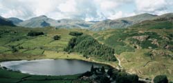
This Lake District walk can be challenging as it covers open fells with waterfalls adding wet conditions to the route. In bad weather, good boots, waterproof clothing, map and compass are essential. As a bonus you are in the centre of the Lake District National Park with 360 degree unrestricted views of the fells and mountains - the mass of Helvellyn to the east, Fleetwith Pike and Red Pike to the west, Coniston Old Man to the south but the best views are north to Skiddaw and Blencathra.
The walk starts from the lovely, peaceful National Trust Hamlet of Watendlath (grid ref 276163) situated at the end of a single track lane, off the B5289 Keswick to Borrowdale road. At first proceed in an easterly direction from the car park climbing part way up the hill before taking the first path on the right, keeping on the left hand side of the wall.
The footpath is very good at first but can be extremely wet on reaching the remote Blea Tarn (grid ref 290143). Meaning 'Blue Tarn' it is in an very impressive location flanked on one side with the cliffs of Low Saddle. Follow the wet footpath to the left (east) of the tarn. Go over the stile at the boundary fence then turn right to follow a path that climbs steeply through a gully to the left of the imposing Standing Crag.
This path (not indicated on all maps) swings right after the gully near the top to meet the boundary fence behind Standing Crag. Follow the well-worn path with the fence on your right until you reach the corner of the fence where the fence turns sharp right. Keep straight on following the boundary posts gradually climbing up to the cairn on Ullscarf (grid ref 292121). After enjoying the view continue to follow the boundary posts proceeding to Greenup Edge (grid ref 286105).
At this point turn right down the good path that descends steeply to Smithymire Island. The path follows Greenup Gill and depending on recent rainfall, can be full of challenges as you cross through the waterfalls. On reaching Smithymire Island (grid ref 275130) follow the path north west alongside the beautiful Stonethwaite Beck to the outskirts of Rosthwaite. Cross over the river bridge (grid ref 259150) then its straight-on to follow the very wide path that climbs up steeply north and later north-west via Birkett's Leap (grid ref 264157) and Puddingstone Bank before dropping down to the packhorse bridge at Watendlath and your start.
Other walks nearby
| Walk 1693 | Grange & Watendlath from Rosthwaite | easy/mod | 7.6 miles |
| Walk 1444 | Great Gable (Borrowdale route) | hard | 12.0 miles |
| Walk 1268 | Cat Bells & High Spy | moderate | 8.0 miles |
| Walk 3328 | Eagle Crag & Seargeant's Crag from Stonethwaite | moderate | 7.0 miles |
| Walk 3133 | Ullscarf and Watendlath from Stonethwaite | mod/hard | 10.0 miles |
| Walk 3132 | High Tove & Blea Tarn | moderate | 7.6 miles |
| Walk 1108 | Ashness Bridge & Grange Fell | moderate | 9.0 miles |
| Walk 1175 | Combe Gill Circuit | moderate | 5.5 miles |
| Walk 1247 | Helvellyn & Raise from Swirls | mod/hard | 7.0 miles |
| Walk 2025 | Helvellyn & Wythburn from Swirls | mod/hard | 8.5 miles |
Recommended Books & eBooks
Walking the Lake District Fells - Patterdale
 Part of the Walking the Lake District Fells series, this guidebook covers a wide range of routes to 35 Lakeland summits that can be climbed from Ambleside, Grasmere and Patterdale and the Thirlmere and Ullswater valleys, with highlights including Helvellyn and Fairfield. Suggestions for longer ridge routes are also included.
More information
Walking the Lake District Fells - Mardale and the Far East
 Part of the Walking the Lake District Fells series, this guidebook covers a wide range of routes to 36 Lakeland summits that can be climbed from the Ullswater, Haweswater, Troutbeck, Kentmere and Longsleddale valleys, with highlights including High Street, Place Fell and the Kentmere fells. Suggestions for longer ridge routes are also included.
More information
Messaging & Social Media
Message Walking Britain and follow the latest news.

Mountain Weather
Stay safe on the mountains with detailed weather forecasts - for iOS devices or for Android devices.