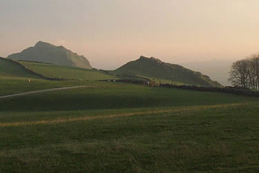
High Edge & Chrome Hill from Hollinsclough
Peak District Walk
Nat Park - Peak District - Dove Valley Chrome Hill
County/Area - Staffordshire & Derbyshire
Author - Mike Bexley
Length - 8.5 miles / 13.8 km Ascent - 1400 feet / 424 metres
Time - 5 hours 40 minutes Grade - moderate
Maps 

| Ordnance Survey Explorer OL24 | Sheet Map | 1:25k | BUY |
| Anquet OS Explorer OL24 | Digital Map | 1:25k | BUY |
| Ordnance Survey Landranger 119 | Sheet Map | 1:50k | BUY |
| Anquet OS Landranger 119 | Digital Map | 1:50k | BUY |
Walk Route Description
Click image to visit gallery of 3 images.
The limestone mass of Chrome Hill dominates Hollinsclough and provides a focus for this excellent Peak District walk. This hike takes you up the higher reaches of the pretty River Dove with the reward of standing on the top of Chrome Hill towards the end. The route is very descriptive due to the scarcity of signposts and footpath markers.
From Hollinsclough Village (Grid ref. 065665) walk up the road to the left of the Chapel turning right at the first footpath. Do not proceed down hill but take the footpath veering left that contours across the flank of Hollinsclough Rake. At Moorside follow the wall turning right through a gap to pass a ruined barn continuing down to Washgate Ford and the Packhorse Bridge (Grid ref. 052673), a classic location for the camera. In years gone by the local farmers washed their sheep here prior to shearing.
Cross over the bridge, continuing up the stony lane turning left at the first footpath to follow the right bank of the upper reaches of the River Dove. On reaching the next bridge proceed up the footpath ahead, across a field to a wall stile. Careful navigation is required in this area and the OS Explorer map is useful in some respects. You should stay on the marked rights of way (green dotted lines) rather than use the dotted 'other paths' shown on the map. Continue straight on passing Howe Green Farm which should be away to your right (Grid ref. 048682 ) to join a bridleway that drops down past the ruins of Brand End Farm to a stone slab over a brook.
Walk up the field ahead turning left through the gate posts. Continue for a short way along this bridleway then it's down to the wet left hand corner of the field (Grid ref. 050687) and over the stile, keeping to the right of a small brook. On reaching a footpath indicator post climb up the bank on the right. Go over a broken stile in the fence and continue up the field towards the buildings turning left to follow the fence. Turn right through the stone gap and left over the wide low stile. Keep straight on until you reach a small pond. The path has been diverted here so it is not shown on the map. Turn right after the pond climbing up the field to the drive. Cross the stile and go left down to Fairthorn (Grid ref. 042692).
Continue past the buildings to reach a wide path through a gorge with the stream low down on your left. At the bridge turn right, climbing up and keeping straight on over the moor to reach a road (Grid ref. 043698). Cross over the road and continue down the bridleway to the buildings at Turncliff. On the way down you pass sentry type boxes and large industrial footpath signs. This is because you are entering the boundaries of the Health & Safety Executive's Explosive Laboratory. Keep smiling as you are no doubt on camera.
Continue past the buildings down to their private road, which used to be a railway line. Turn right, passing the traffic lights, then right again through a cutting to follow the footpath to Grid ref. 053693. Turn right here up the field to the road. On reaching the road turn left towards High Edge Raceway. Just after the cattle grid turn right along the lane passing the directions to Booth Farm. Turn right (Grid ref. 065683) towards Stoop Farm. Do not go as far as the farm but turn left prior to going down hill and use the concessionary path that follows the fence. Turn right at the footpath post heading downhill and go left over the stile.
The clear onward footpath climbs up to Chrome Hill with views all the way. Take care as in wet conditions limestone can be very slippery. Continue along the spine of Chrome Hill dropping down the steep side to reach a farm lane (Grid ref. 077671). Parkhouse Hill ahead has no right of way for walkers although a quick ascent might be tempting! Instead turn right along the lane in the direction of Glutton Bridge and right again at the next lane. This heads back across the River Dove and leads you west. Stay on this track to reach a road. Turn right and you are soon back at the start in Hollinsclough.
Other walks nearby
| Walk 1861 | Chrome and Parkhouse Hills from Earl Sterndale | easy/mod | 5.0 miles |
| Walk 1862 | Earl Sterndale and High Wheeldon from Longnor | easy/mod | 6.0 miles |
| Walk 2723 | Pilsbury Castle, Hartington & Sheen from Longnor | easy/mod | 9.6 miles |
| Walk 2272 | Flash Circular from Cistern Clough | moderate | 8.0 miles |
| Walk 1043 | Chelmorton & the Monsal Trail | easy/mod | 8.1 miles |
| Walk 3709 | Sparklow, Crowdicote & Pilsbury Circular | easy/mod | 9.0 miles |
| Walk 1652 | Three Shires Head | easy | 4.5 miles |
| Walk 2233 | Flash & Three Shires Head | easy/mod | 6.2 miles |
| Walk 2577 | Hawk's Nest, Goldstitch Moss & Lud's Church | moderate | 8.0 miles |
| Walk 1596 | Lud's Church and Roach End from Gradbach | easy/mod | 4.5 miles |
Recommended Books & eBooks
Walking in the Peak District - White Peak East
 Guidebook describing 42 half-day and day walks in the limestone landscapes of Derbyshire's White Peak, part of the Peak District National Park. One of two volumes, this book covers the east of the region, with potential bases including Bakewell, Eyam, Castleton, Birchover, Matlock and Wirksworth.
More information
Dark Peak Walks
 Guidebook to 40 walks in the Dark Peak area of the Peak District National Park. 35 circular routes for most abilities, from 8km to 19km, around Edale, Marsden, Fairholmes, Baslow and Castleton, including Kinder Scout and Mam Tor, and 5 longer (25km to 45km) routes highlighting the best of the Gritstone Edges, High Moorland and Deep Valleys.
More information
Messaging & Social Media
Message Walking Britain and follow the latest news.

Mountain Weather
Stay safe on the mountains with detailed weather forecasts - for iOS devices or for Android devices.