Moel Hebog, Moel yr Ogof & Moel Lefn from Beddgelert
Snowdonia/Eryri Walk
Nat Park - Snowdonia - Moel Hebog Nantlle Ridge
County/Area - Gwynedd
Author - Nick O'Brien
Length - 6.5 miles / 10.6 km Ascent - 3450 feet / 1045 metres
Time - 6 hours 40 minutes Grade - mod/hard
Maps 

| Ordnance Survey Explorer OL17 | Sheet Map | 1:25k | BUY |
| Anquet OS Explorer OL17 | Digital Map | 1:25k | BUY |
| Ordnance Survey Landranger 115 | Sheet Map | 1:50k | BUY |
| Anquet OS Landranger 115 | Digital Map | 1:50k | BUY |
Walk Route Description
Click image to see photo description.
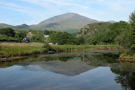
The village of Beddgelert is a popular starting place for walks onto Moel Hebog (782 m.), which rises to the west of the village. Starting at a very low altitude this walk offers great climbing, fantastic views and has a mysterious charm. However it involves some serious mountain terrain and should not be taken lightly. There is a large car park (grid ref. SH587481). The start (Grid ref. 585483) for this Snowdonia (Eryri) walk is on the A4085 Beddgelert to Caernarfon road about 500 metres from the road junction in the centre of the village.
Cross the bridge over the river and follow the track past a couple of farmhouses and through woods to reach a barn (Grid ref. 581479). Immediately after the barn there is a gate. Go through this and follow the path, which is reasonably well defined and has route markers at low level.
After a short distance from the barn the climbing starts and it is a steep pull all the way to the summit of Moel Hebog. The path continues on an ill-defined ridge and continues to the left of the spectacular crags, Y Diffws, after which there is some light scrambling. Looking back you get a superb view of Snowdon together with terrific views to Beddgelert and the Dinas Valley.
The path becomes rocky and is marked by piles of stones. This section leads to a grassy shoulder which in turn leads to another short rocky section and the summit plateau. Most of the ascent is now complete and you can enjoy the views. Snowdon is well known but some lesser known peaks to the north are also worthy of your attention, including namely Mynydd Drws-y-coed. In addition Mynydd Graig Goch at the western end of the Nantlle ridge is also prominent.
From the summit of Moel Hebog the next leg of the walk heads north following the wall down towards and impressive rock formation at the foot of Moel yr Ogof. From here it is a short but steep climb to the top of Moel yr Ogof. This peak has strong connections with Owain Glyndwr who is reported as using a cave as a hiding place.
Leaving Moel yr Ogof head north again descending to a col before climbing once more onto the summit of Moel Lefn, which provides a suitable place for a rest. It is also worth spending a few minutes examining the forest on the eastern slopes as this will be used for the descent.
Descend east towards the woodland and pick up either the track or a combination of tracks and paths that lead down through the woods to the campsite (Grid ref. SH577491). Care is needed as some of the tracks lead to dead ends so it is worth taking your time with navigation. Continue through the campsite to the road and walk the short distance back to the starting point. From the road you get stunning views of Moel Hebog on your right.
Other walks nearby
| Walk 1427 | Craflwyn circular from near Beddgelert | easy/mod | 2.5 miles |
| Walk 3058 | Llyn yr Adar & Llyn Edno from near Bethania | moderate | 9.0 miles |
| Walk 1192 | Yr Aran | mod/hard | 6.5 miles |
| Walk 1103 | Snowdon & Cwm Llan horseshoe | very hard | 13.0 miles |
| Walk 2290 | Snowdon via the Watkin Path & South Ridge from Bethania | mod/hard | 8.0 miles |
| Walk 1136 | Yr Aran (Route 2) | moderate | 5.5 miles |
| Walk 1515 | Tops and Tarns of the Moelwyns | mod/hard | 11.0 miles |
| Walk 2590 | Nantlle Ridge Walk from Rhyd Ddu (Route A) | moderate | 6.0 miles |
| Walk 2797 | Yr Aran and Snowdon from Rhyd-Ddu | mod/hard | 8.5 miles |
| Walk 3509 | Nantlle Ridge from Rhyd Ddu (Route B) | mod/hard | 8.3 miles |
Recommended Books & eBooks
Great Mountain Days in Snowdonia
 Inspirational guidebook to 40 great mountain day walks and scrambles in Snowdonia. Inspirational routes for all abilities across the National Park with routes up Snowdon and Moel Eilio, the Glyderau, the Carneddau, Eifionydd, Siabod and the Moelwynion, Rhinogydd (the Harlech Dome), Migneint and the Arans and Cadair Idris and the Tarrens.
More information
Snowdonia: 30 Low-level and easy walks - North
 Guidebook describing 30 walks in Snowdonia, Wales. Routes are mostly low level and on clear paths and showcase the region's beautiful scenery and rich history and culture. Part of a 2-volume set, this northern volume includes the Snowdon area, the Ogwen and Conwy Valleys, Betws-y-Coed, Beddgelert, Ffestiniog and the coast.
More information
Messaging & Social Media
Message Walking Britain and follow the latest news.

Mountain Weather
Stay safe on the mountains with detailed weather forecasts - for iOS devices or for Android devices.