Valley of Desolation & Barden Fell
Yorkshire Dales Walk
Nat Park - Yorkshire Dales - Lower Wharfedale
County/Area - North Yorkshire
Author - Bob Hawes
Length - 11.0 miles / 17.9 km Ascent - 1900 feet / 576 metres
Time - 7 hours 20 minutes Grade - moderate
Maps 

| Ordnance Survey Explorer OL2 | Sheet Map | 1:25k | BUY |
| Anquet OS Explorer OL2 | Digital Map | 1:25k | BUY |
| Ordnance Survey Landranger 104 | Sheet Map | 1:50k | BUY |
| Anquet OS Landranger 104 | Digital Map | 1:50k | BUY |
Walk Route Description
Click image to see photo description.
The start of this Yorkshire Dales walk is Bolton Abbey car park in Wharfedale (Grid ref. 070 538). Leave the car park at the north end, turn right and walk I00yds into the village. Turn left along the main road for 50 yards then go right down the driveway to Bolton Priory. Continue to a gate and out onto the road. After 200yds, at the Cavendish Memorial, keep straight on with the fence on the right to cross a stile and go down some steps. Walk across the field towards the river; follow the river upstream to the Cavendish Pavilion cafe where you turn right to cross the wooden bridge over the River Wharfe ( Grid ref. 073 541).
Once across the bridge, turn immediately left onto the wide path and walk upstream. The path soon bears right and climbs a few stone steps to cross a wooden stile. Take the right fork and climb the path to the road. Turn left up this minor road, climbing a short hill before the road levels off. After about 200 yards turn right to a gate by a cottage (Grid ref. 075 556).
Go through this and bear left across the field to another gate, from which a track leads up the valley. This goes over a slight rise and then bends left to descend to the gill. Fork right over the grass path, up the hillside and round the top of a gully before descending to a bridge across Posforth Gill. Follow the path up the valley with the stream on your right. At a fork bear left and climb to a ladder stile at the edge of a wood. Cross the stile, bear right and follow the wide track through the wood to leave by a gate at the end.
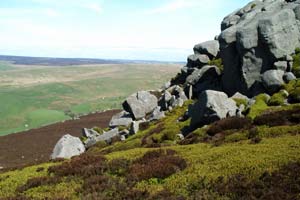
The track continues up, over the open moor to the summit of Simon's Seat, Becoming a cairned footpath for the last part of the route. Take care not to turn right half way up the track at grid ref. 079 597. From the trig point turn right, along a faint path towards Lord's Seat (Grid ref: 084 598). This part of the route is quite muddy.
When you reach a wall by the outcrop, turn right and follow a footpath alongside it. This becomes a more distinct track as it descends towards Little Agill Beck. Just before the beck the track passes through a gate in the wall and continues along the other side of it for a short distance before swinging back to the right, through another gate, to continue on the right-hand side of the wall. Follow the track through a gate by a stone shelter (Grid ref. 097 583).
The track now climbs a little before levelling off. It then veers to the right away from the wall, crosses a small stream and starts to gently descend across the moor. Ignore a track, which joins from the left. At the next junction bear left (Grid ref: 091 566).
The track descends to cross a stream at a ford. Continue up the same track. Bearing right whenever the track forks, keeping a roughly south-westerly direction and gradually descending towards the Wharfe valley in front of you. Eventually the track crosses a cattle grid; there is a notice board on the right by a farm entrance giving information about the access area. About I00yds further on, go down a footpath to the right, following a wall on the right, to a minor road at Storiths (Grid ref: 081 543).
Go down the lane opposite the footpath, following it round to the right. Where the road ends at a farm, take a footpath down between two walls until it emerges at the top of a hill above the River Wharfe, with Bolton Priory opposite. Bear right and follow the path downhill to cross the river by the bridge. The path continues across the fields and up some steps to emerge through an archway in a wall at Bolton Abbey.
Other walks nearby
| Walk 1001 | Barden Bridge & the Strid | easy | 4.0 miles |
| Walk 1249 | Simon's Seat | moderate | 10.0 miles |
| Walk 1946 | Valley of Desolation & Simon's Seat | moderate | 8.4 miles |
| Walk 1905 | Beamsley Beacon and Bolton Abbey | moderate | 10.0 miles |
| Walk 2942 | Below Silsden Moor | easy/mod | 6.8 miles |
| Walk 2319 | Ilkley to Bingley | easy/mod | 7.0 miles |
| Walk 3079 | Silsden Reservoir circular | easy | 6.0 miles |
| Walk 1280 | Trollers Gill | moderate | 9.0 miles |
| Walk 2000 | Wharfedale Circular | moderate | 13.5 miles |
| Walk 1811 | Sharp Haw in Airedale | easy/mod | 7.0 miles |
Recommended Books & eBooks
Walking in the Yorkshire Dales: South and West
 Part of a two-book set, this guidebook describes 44 walks in the southern and western Yorkshire Dales, including the famous 23 mile Three Peaks circuit over Pen-y-Ghent, Whernside and Ingleborough. The other, mostly circular routes of 3½ to 13 miles cover the scenic region between Sedbergh, Kirkby Lonsdale, Settle, Skipton and Grassington.
More information
Trail and Fell Running in the Yorkshire Dales
 Guidebook to 40 of the best trail and fell runs in the Yorkshire Dales National Park. Ranging from 5 to 24 miles, the graded runs start from bases such as Ribblehead, Dent, Sedbergh, Malham and Grassington and take in the region's diverse delights, from castles and waterfalls to iconic mountains such as Whernside, Ingleborough and Pen Y Ghent.
More information
Messaging & Social Media
Message Walking Britain and follow the latest news.

Mountain Weather
Stay safe on the mountains with detailed weather forecasts - for iOS devices or for Android devices.