Hawk's Nest, Goldstitch Moss & Lud's Church
Peak District Walk
Nat Park - Peak District - The Roaches
County/Area - Staffordshire
Author - Mike Bexley
Length - 8.0 miles / 13 km Ascent - 1600 feet / 485 metres
Time - 5 hours 40 minutes Grade - moderate
Maps 

| Ordnance Survey Explorer OL24 | Sheet Map | 1:25k | BUY |
| Anquet OS Explorer OL24 | Digital Map | 1:25k | BUY |
| Ordnance Survey Landranger 118 | Sheet Map | 1:50k | BUY |
| Anquet OS Landranger 118 | Digital Map | 1:50k | BUY |
| Ordnance Survey Landranger 119 | Sheet Map | 1:50k | BUY |
| Anquet OS Landranger 119 | Digital Map | 1:50k | BUY |
Walk Route Description
Click image to see photo description.
Starting from Gradbach Car Park, close to the YHA Hostel, this Peak District walk will take you to the rarely visited Quarnford area before visiting Lud's Church. You can also visit Three Shires Head with its important packhorse bridge, widened to take the extra traffic of the pony trains. This extension adds 1.5 miles (2.5 km) to the route and another 300 feet (90 m.) of ascent.
From the car park entrance (Grid ref SJ998662) exit left. Then cross over the river via the footbridge and the meadows to the road ahead. Turn right at the road then left at the building. The path climbs straight up the fields following the wall on your left to cross a footpath to reach a bridleway (Grid ref 009675).
By walking left on this bridleway you can visit Three Shires Head. It is a lovely quiet spot. The 'Y' shape of the three rivers forms the boundary of Cheshire, Staffordshire and Derbyshire. Local folklore recounts of a man named Harry who used to make counterfeit money, selling it to travellers. When the police got wind of him he would cross over the river into the another County and so avoid arrest. He lived in nearby Flash, hence the name 'Flash Harry'.
If you want to miss out Three Shires Head turn right along the bridleway ignoring the first wide path to turn right down a narrow path just prior to Hawk's Nest (Grid ref 016674). This path drops down to the river which can be a problem to cross if the river is in flood. Assuming you are safely across, climb up to the path ahead to pass Far Brook Farm on your left. On reaching the road go right.
Turn left at the next footpath. This passes a farm onto the moor with few footpath signs. Proceed in a southerly direction over the stiles and through wall gaps until you reach a barn, within sight of a road (Grid ref 016663). Turn right at this building to contour the hill then drop down to the road on your left (Grid ref 013663) following footpaths marked on maps.
Cross over the road to take the stile ahead and down the steep hill to the river. Climb up the gully ahead joining a well defined path that takes you in front of a farmhouse to Green Gutter Head. Turn left through the mushroom farm and its buildings to the reach road.
Turn right along the road, going straight on at the cross roads (Grid ref 012650) to join the farm road to Goldstitch House. Turn right at the house following and follow the path alongside the river through the valley. The path is well defined and crosses over the river prior to climbing up through the bracken to the gap near Bearstone Rock and Roach End.
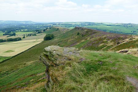
There used to be several Wallabies in this area, originally escapees from a nearby private zoo, but they have not been seen for many years. However this might be your lucky day! Proceed up to the top of the path (Grid ref 995645) and turn right through the wall gap to follow the path along the ridge with excellent views over the Cheshire plains. Eventually the path drops down at the end of the ridge and you should turn right at this point and follow the good path descending to a group of large rocks.
Here there is a finger post sign to Lud's Church. A dramatic deep cleft in the forest rocks 50 feet deep, steps lead into the chasm and it's well worth the visit. Historic details are quoted in Walk No 1178.
Return to the rocks and follow the path that descends through the trees to a bridge over Black Brook. Staying on this path follow the River Dane through the grounds of the Youth Hostel and up its drive to reach lane. Turn left to reach the start.
Other walks nearby
| Walk 1652 | Three Shires Head | easy | 4.5 miles |
| Walk 2233 | Flash & Three Shires Head | easy/mod | 6.2 miles |
| Walk 1178 | Roaches and Lud's Church | moderate | 7.3 miles |
| Walk 1707 | The Roaches short circular | easy/mod | 5.0 miles |
| Walk 3030 | Roaches & Lud's Church | easy/mod | 7.0 miles |
| Walk 2272 | Flash Circular from Cistern Clough | moderate | 8.0 miles |
| Walk 1728 | Axe Edge Moor & Three Shires Head | easy/mod | 7.2 miles |
| Walk 3136 | Shining Tor & Goyt's Clough | easy/mod | 5.1 miles |
| Walk 1183 | Shining Tor & Axe Edge Moor | moderate | 9.0 miles |
| Walk 1288 | Roaches & Hen Cloud from Tittesworth Reservoir | moderate | 8.5 miles |
Recommended Books & eBooks
Walking in the Peak District - White Peak East
 Guidebook describing 42 half-day and day walks in the limestone landscapes of Derbyshire's White Peak, part of the Peak District National Park. One of two volumes, this book covers the east of the region, with potential bases including Bakewell, Eyam, Castleton, Birchover, Matlock and Wirksworth.
More information
Dark Peak Walks
 Guidebook to 40 walks in the Dark Peak area of the Peak District National Park. 35 circular routes for most abilities, from 8km to 19km, around Edale, Marsden, Fairholmes, Baslow and Castleton, including Kinder Scout and Mam Tor, and 5 longer (25km to 45km) routes highlighting the best of the Gritstone Edges, High Moorland and Deep Valleys.
More information
Messaging & Social Media
Message Walking Britain and follow the latest news.

Mountain Weather
Stay safe on the mountains with detailed weather forecasts - for iOS devices or for Android devices.