Crook Hill & Ladybower Reservoir
Peak District Walk
Nat Park - Peak District - Great Ridge Castleton
County/Area - Derbyshire
Author - Jake Robertson
Length - 7.5 miles / 12.2 km Ascent - 1200 feet / 364 metres
Time - 5 hours 0 minutes Grade - easy/mod
Maps 

| Ordnance Survey Explorer OL1 | Sheet Map | 1:25k | BUY |
| Anquet OS Explorer OL1 | Digital Map | 1:25k | BUY |
| Ordnance Survey Landranger 110 | Sheet Map | 1:50k | BUY |
| Anquet OS Landranger 110 | Digital Map | 1:50k | BUY |
Walk Route Description
Click image to see photo description.
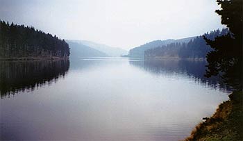
This is a delightful Peak District walk starting with an ascent of Crook Hill, which is often ignored by walkers, before a stroll along the eastern banks of Ladybower Reservoir. The start is the car park at Fairholmes reached off the A57 Snake Pass road from Sheffield to Glossop.
Leave Fairholmes and go down the main road until you see a gate and sign pointing to Lockerbrook Farm on the other side of the road. Follow the path through the woods, ascending to reach a track near the farm. Turn left and walk along the track past Lockerbrook Farm to reach a junction. Take a small path on the left to stay on the edge of the woods and bend round to a gate.
Pass through the gate and walk by the edge of the woods to reach two stiles. Go over both stiles and make your way over Bridge-end Pasture then slope down to come to another gate and a signpost.
Follow the path leading to the Snake Road into a field containing the twin tops of Crook Hill. Shortly after entering the field leave the path and head left towards the eastern slope of the first top then climb up the grassy bank once you are past the rocks on the north side.
The views from this hill are magnificent, despite a height of only 382m. From the first top drop down the grassy bank then climb up onto the second hill. The 374m summit is not as clearly defined as the first hill but the views are equally as good.
Leave Crook Hill and descend eastwards to join the main path. You should be near a path that leads through a field by-passing Crookhill Farm to join a road. Turn left and follow the road down to the Fairholmes road. Turn right and follow this road to meet the A57. Cross the viaduct then turn left to get onto the track which follows the banks of the reservoir for approximately 2 miles before sloping left down through the woods back to Fairholmes car park.
Other walks nearby
| Walk 1489 | Blackden Brook, Kinder & Upper Ashop | moderate | 6.8 miles |
| Walk 3049 | Bleaklow Stones from Derwent Valley | mod/hard | 12.0 miles |
| Walk 2588 | Win Hill & Hope Cross | moderate | 7.5 miles |
| Walk 3540 | The Derwent Edge from Cutthroat Bridge | moderate | 10.0 miles |
| Walk 1286 | Castleton Great Ridge & Mam Tor | moderate | 8.5 miles |
| Walk 2599 | Kinder Scout and Castleton Ridge from Hope | mod/hard | 13.5 miles |
| Walk 1706 | Win Hill from Hope | easy/mod | 6.5 miles |
| Walk 1159 | Grindsbrook & Edale Head | moderate | 7.5 miles |
| Walk 1264 | Rushup Edge & Crowden Tower | moderate | 10.0 miles |
| Walk 1295 | Ringing Roger & Edale Cross | moderate | 10.0 miles |
Recommended Books & eBooks
Walking in Derbyshire
 Walking guidebook to 60 circular day walks in Derbyshire and the Peak District. Includes the Derwent, Wye and Trent river valleys, near Derby, Matlock, Glossop, Bakewell and Ripley. Routes range from easy to moderate and are between 4 and 14km (2 to 10 miles). Walks focus on places of interest, from Stone Age forts to castles to grand estates.
More information
Great Mountain Days in the Pennines
 An inspirational guidebook to 50 classic walks on the rolling Pennine landscape. The graded routes, between 6 and 13 miles in length, cover classic Pennine fells and moorland such as Whernside, Ilkley Moor and Pendle Hill; exploring the North and South Pennines, Yorkshire Dales, Howgills and Dark Peak. Many routes are also suited to fell running.
More information
Messaging & Social Media
Message Walking Britain and follow the latest news.

Mountain Weather
Stay safe on the mountains with detailed weather forecasts - for iOS devices or for Android devices.