Liathach, Glen Torridon
Highland Walk
County/Area - Highland - Central Highland
Author - Paul Gasson
Length - 8.5 miles / 13.8 km Ascent - 4450 feet / 1348 metres
Time - 8 hours 40 minutes Grade - very hard
Maps 

| Ordnance Survey Explorer 433 | Sheet Map | 1:25k | BUY |
| Anquet OS Explorer 433 | Digital Map | 1:25k | BUY |
| Ordnance Survey Landranger 25 | Sheet Map | 1:50k | BUY |
| Anquet OS Landranger 25 | Digital Map | 1:50k | BUY |
Walk Route Description
Click image to see photo description.
This is a stunning and challenging walk over one of Scotland's real giants!
Take the narrow road ( A896) up the glen from the village of Torridon, to a lay by at NG936566, close to the Allt a Doire Gharb. The seemingly impossible bulk of Liathac towers above you and the hard work starts almost from the road. No worries about a long walk in HERE!
A narrow path climbs steeply up the right hand side of the stream ( true left bank!) towards Coire Liath Mhor high above. Follow the path almost to the mouth of the great cleft in the cliffs above, from where the path traverses right to gain the ridge just short of Stuc a Choire Dhuib Bhig. This will probably take about two hours, or more!
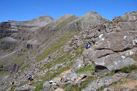
Follow the ridge more of less West, over a number of minor tops, towards the main peak of Spidean a Choire Leith. The views from here are stunning in every direction, given good weather (always at a premium in Torridon!) and the summit is probably a good spot to take a lunch break before continuing.
The path onwards is vague, but leaves the summit in a southerly direction, before making its way steeply down over rocks to the Am fasarinen Pinnacles. Competent scramblers will want to tackle the Pinnacles directly, which present few real difficulties other than considerable exposure, making the use of a rope prudent in parts. The alternative is a horizontal path to the south side of the pinnacles. This weaves in and out around the Pinnacles, nowhere difficult at all, but very narrow and with a vertical drop to one's left to the glen road nearly 3000ft. below. A final turn brings the end of the narrow path, and a broad, easy angled shoulder leading up to the final peak, Mullach an Rathain to complete the traverse.
The descent path leaves the summit just west of south at first, then turns almost due south to drop into Toll Ban over steep but easy scree, then steep, ankle turning grass slopes until you reach the stream of Allt an Toll Bhain and a clear path back to the road about a mile and a half from your car! At least the waters of the River Torridon offer refreshments to one's feet before the trudge back up the glen to complete a walk that should live in your memories for many years.
NOTE! In the foggy weather which often prevails in Torridon, route finding and navigation will be at a premium and I would suggest this route ONLY be attempted under ideal weather conditions.
Other walks nearby
| Walk 2116 | Beinn Eighe Route Guide | hard | 13.0 miles |
| Walk 2117 | Beinn Eighe - West to East traverse, Torridon | hard | 12.3 miles |
| Walk 2118 | Beinn Eighe traverse including Black Carls, Torridon | hard | 12.5 miles |
| Walk 2119 | Beinn Eighe - The Munros & Sail Mhor, Torridon | hard | 13.0 miles |
| Walk 2120 | The Munros of Beinn Eighe, Torridon | hard | 10.8 miles |
| Walk 3268 | Loch Coire Mhic Fhearchair (Beinn Eighe) | moderate | 8.3 miles |
| Walk 1344 | Beinn Alligin & Sgurr Mor | mod/hard | 6.0 miles |
| Walk 1305 | Sgurr nan Fhir Duibhe from Kinlochewe | hard | 7.5 miles |
| Walk 1347 | Meall a' Ghiubhais from Kinlochewe | moderate | 8.0 miles |
| Walk 2468 | The Falls of Glomach from Morvich | moderate | 7.5 miles |
Recommended Books & eBooks
Great Mountain Days in Scotland
 Inspirational guidebook to 50 challenging routes for mountaineers, scramblers, hillwalkers and fell runners, many long enough to backpack over 2 days, especially in winter (12 to 25 miles). A mix of classic routes and unsung gems across Scotland from Galloway to the Outer Hebrides in widely differing wild landscapes. With customised OS mapping.
More information
Walking in Torridon
 This guidebook contains 52 day walks in Torridon, a remote and much-loved area of the Scottish Highlands. Based around Shieldaig and Slioch, the routes are split into 3 sections: easy walks, long and high level walks and mountain ascents over 2000ft including 9 Munros, and 5 outline suggestions for major ridge walks.
More information
Messaging & Social Media
Message Walking Britain and follow the latest news.

Mountain Weather
Stay safe on the mountains with detailed weather forecasts - for iOS devices or for Android devices.