Ruabon Mountain, World's End & Panorama Circular
Denbighshire Walk
County/Area - Denbighshire
Author - Mike Bexley
Length - 12.5 miles / 20.3 km Ascent - 1700 feet / 515 metres
Time - 8 hours 0 minutes Grade - moderate
Maps 

| Ordnance Survey Explorer 256 | Sheet Map | 1:25k | BUY |
| Anquet OS Explorer 256 | Digital Map | 1:25k | BUY |
| Ordnance Survey Landranger 117 | Sheet Map | 1:50k | BUY |
| Anquet OS Landranger 117 | Digital Map | 1:50k | BUY |
Walk Route Description
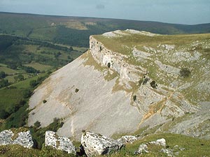
Click image to see photo description.
A walk full of contrasts. It starts from the canal in Trevor village with views of the canal aqueduct, Pont Cysyllte, spanning the Dee Valley built by Telford. The route soon climbs up to the heather and bilberry of the moors before dropping down to Worlds End. The return is via the Offa's Dyke path with its unforgettable views of the Vale of Llangollen.
Start from the large car park near the canal (Grid ref. SJ272423) walk northwest up to the main A539 road. You can take the footpath opposite to Tower Hill but the unmarked paths across the fields can be frustrating so early into the walk. Much more preferable is to turn right along the main road then left at the first lane. This is Tower Hill and it climbs up to Nant Uchaf Farm (Grid ref. SJ 258 436). Turn right off the road, passing the holiday cottages and the farm to follow a wide track to another road. Turn right on the road then next left up the lane passing Bryn-Adda to a stile at the top.
Bear right (northeast) to follow a very feint path that crosses the corner of the moor towards a gate at the derelict buildings of Frozen Clock. Look out for a plastic sleeve near the gate that details the history of the name. There are two explanations quoted - it used to get so cold that the clock workings frequently froze or alternatively the owner stopped it to obtain a longer working day from his miners. The gate is unique as it is the only one I have climbed over that has stirrups.
Care is required for the next short stage. Keeping the same heading leave the Frozen Clock following the fence and low wall on your right. At the end of the wall bear left into the left field then keep close to its right hedge to drop down to a stile into the woods. A pleasant path descends to a footbridge. At the path junction (Grid ref. SJ 261456) turn left climbing up through the woods to its boundary. The very narrow path steadily climbs up onto the moor. Contrary to the map, the path sweeps further to the left. Do not be tempted to take any of the many seemingly short cuts as they lead to dead ends. The path eventually descends to a path junction (Grid ref. SJ 243 476). Turn left, cross over a bridleway to reach a stile into the woods at picturesque World's End. A good place to stop for lunch.
Continue down the path to the road and ford. Turn left then left at the footpath sign. You have now joined the Offa's Dyke Path National Trail indicated by an acorn. This path will take you almost back to your start, at first as a narrow path contouring steep slopes before joining the road at Rock Farm. The wonderful views of Vale of Llangollen continue as you walk the road passing the ruined Castell Dinas Bran. Still following the acorn sign bear left at the road junction and pass an old quarry on the left.
The road then takes a dogleg bend. At the next left corner follow the acorn signed stony lane on the right (Grid ref. SJ 241 429). Note - maps incorrectly do not show this as the Offa's Dyke Path indicating instead the next path off the road. The stony lane leads to gates. Turn right to follow the path skirting the property after which it is a nice long stroll through the woods, still following the acorn signs. You will exit at the drive and gates leading to Trevor Hall. Turn left to the road then right before crossing the stile on the left. This leads over a field to another road. Turn right descending to the main A539. Turn left along this road then right down to the canal and your start.
Other walks nearby
| Walk 2460 | Pontcysyllte Aqueduct Circular | easy | 4.5 miles |
| Walk 1067 | Ruabon Mountain & The Limestone Edges of Llangollen | moderate | 11.0 miles |
| Walk 2388 | Chirk Castle & Ceiriog Valley | easy/mod | 6.0 miles |
| Walk 1845 | Castell Dinas Bran from Llangollen | easy/mod | 4.0 miles |
| Walk 3655 | Rhewl, Moel y Gamelin & Moel Morfydd | moderate | 5.4 miles |
| Walk 1989 | Llanarmon Dyffryn Ceiriog Circular | moderate | 6.0 miles |
| Walk 2905 | The Llangollen Canal from Ellesmere | easy/mod | 8.0 miles |
| Walk 3535 | River Dee from Farndon | easy | 4.0 miles |
| Walk 3031 | Cadair Berwyn | moderate | 9.3 miles |
| Walk 1528 | Moel Famau | easy/mod | 10.0 miles |
Recommended Books & eBooks
No suggestions for this area.Messaging & Social Media
Message Walking Britain and follow the latest news.

Mountain Weather
Stay safe on the mountains with detailed weather forecasts - for iOS devices or for Android devices.