The moors and hills of Penwith
Cornwall AONB Walk
Region - Cornwall AONB
County/Area - Cornwall
Author - Jake Robertson
Length - 14.0 miles / 22.8 km Ascent - 2100 feet / 636 metres
Time - 9 hours 10 minutes Grade - moderate
Maps 

| Ordnance Survey Explorer 102 | Sheet Map | 1:25k | BUY |
| Anquet OS Explorer 102 | Digital Map | 1:25k | BUY |
| Ordnance Survey Landranger 203 | Sheet Map | 1:50k | BUY |
| Anquet OS Landranger 203 | Digital Map | 1:50k | BUY |
Walk Route Description
Click image to visit gallery of 3 images.
This linear Cornwall walk crosses the high ground above Penwith's north coast. It is not the easiest of walks with many ascents, tricky navigation and rough terrain but I found it to be a very enjoyable and rewarding day out with numerous surprises and glorious views.
Please note that some of the route may involve minor trespassing because of overgrowth and unclear paths, though when I did the walk, I had no complaints from landowners. It is also worth noting that the walk crosses areas that have seen extensive mining operations and due care is needed when approaching mine shafts and other workings.
The start of the walk is the car park beneath Rosewall Hill (Grid ref. SW 486394) and the finish is Cape Cornwall car park (Grid ref. SW352317).
From the car park beneath Rosewall Hill a path climbs up through the bracken to a dip on the crest. A short detour can be made right on a path to the higher summit where there are excellent views over St Ives Bay though you must return back to the dip. From the dip the path drops down through the fields to Towednack Road. Go right down to a T-junction then walk left to another junction. Turn right and follow the road round and up through Amalveor to Embla Vean (Grid ref SW 481374).
Here a bridleway goes right, climbing over the broad Amalveor Downs with good views of Carn Galver and Watch Croft. Keeping on the main path, one arrives at the road at Higher Kerrow (Grid ref. SW 457362) quicker than expected. Go straight on to meet the main road at the head of the Try Valley. Walk left a little way until you see a stile on the right where a path ascends the scrub slopes to Mulfra Quoit on Mulfra Hill, my preferred lunch stop.
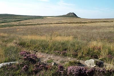
From Mulfra Quoit a clear path goes northwest over the top of Mulfra Hill then drops to a crossing path on Bospothennis Common. Go left along to a track which is followed left (again!) for a short way. Soon a track on the right leads towards Brook Cottage but turn off this before and walk up a path, passing close to the Nine Maiden's stone circle, to a main path over the moor. Turn right (Grid ref. SW 430354) up the track towards the rocky peak of Carn Calver, leaving the track to climb up the rocky slopes to the 249m summit.
Carn Galver is certainly the most exciting hill in Penwith, a sharp rocky ridge with a small and graceful peak. The views are extensive over Land's End and the rest of Cornwall making it very tempting to spend all afternoon in this pleasant location. Sadly you must descend back to the track then continue though rough gorse and heather under White Downs to the trig point atop Watch Croft (Grid ref. SW 420357), the highest hill in Penwith. Unfortunately, it is not as exciting or as interesting as Carn Galver though views from the 252m summit are wide and very expansive.
Leave Watch Croft by heading SSE for a quick but leg scratching descent to a good path which leads, right, to a road (Grid ref. SW 414350). Walk left to a junction then go right on a tight path over Carn Downs to the bottom of Chun Downs. If the path is overgrown it may be necessary to walk through the fields instead. Don't climb the hill but go left down by a wall to Trehyllys Farm (Grid ref. SW 408337). Turn right and follow a clear track over Woon Gumpus Common to another road (Grid ref. SW 395331).
This time cross straight over the road and walk up a clear path to the rocky Carn Kenidjack. Aim for the south facing wall and find the stile (roughly in front of the carn) where a path sets off down to a track passing Hailglower Farm (Grid ref. SW 383322) to a junction. Go right and the track becomes a road leading down through Tregeseal to the B3306 coast road at Nancherrow (Grid ref. SW371318).
Go straight over onto a lane which ends at Kenidjack Farm (Grid ref. SW 365324) where a track continues down the valley to meet the South West Coast Path. Head left and keep with the coast path above Boat Cove where Cape Cornwall appears. The end is in sight! It is necessary to leave the coast path for a smaller path which climbs up to the chimney on the top. Cape Cornwall is a very dramatic place and feels wilder than the over-popular Land's End. Also it is the end of this walk, the car park being a short stroll away down the hill. This sadly ends a glorious day but tired legs now call for a long sit down.
Other walks nearby
| Walk 1225 | Sennen Cove & Botallack from St Just | moderate | 7.5 miles |
| Walk 1028 | Chun Quoit and Botallack | moderate | 8.0 miles |
| Walk 3325 | Chun Quoit & Carn Kenidjack | easy | 4.0 miles |
| Walk 1224 | Men-an-tol & Ding Dong Mine | easy | 3.0 miles |
| Walk 2614 | St Loy's Cove & Logan Rock | moderate | 8.5 miles |
| Walk 1226 | Land's End & Sennen Cove from Porthcurno | moderate | 6.5 miles |
| Walk 2298 | Porthgwarra & St Levan Circular | easy | 4.8 miles |
| Walk 2354 | Merry Maidens & Lamorna Cove | easy | 4.1 miles |
| Walk 2205 | Newlyn - a village trail | easy | 1.0 miles |
| Walk 1081 | Zennor & St Ives coast path | mod/hard | 11.0 miles |
Recommended Books & eBooks
Walking in Cornwall
 This guidebook includes routes to 40 day walks in Cornwall. From short, easy strolls to longer, wilder routes, there is plenty to appeal to both families and experienced walkers. The walks explore the interior and coasts, including walks through picturesque villages, old tin-mining areas and the Lizard and Land's End Peninsulas.
More information
Messaging & Social Media
Message Walking Britain and follow the latest news.

Mountain Weather
Stay safe on the mountains with detailed weather forecasts - for iOS devices or for Android devices.