Martindale High-level Circuit
Lake District Walk
Nat Park - Lake District - Lake District Far Eastern Fells
Wainwrights - Beda Fell, High Raise, The Knott, Rest Dodd, Steel Knotts
County/Area - Cumbria
Author - Andrew Wright
Length - 11.0 miles / 17.9 km Ascent - 3600 feet / 1091 metres
Time - 9 hours 10 minutes Grade - mod/hard
Maps 

| Ordnance Survey Explorer OL5 | Sheet Map | 1:25k | BUY |
| Anquet OS Explorer OL5 | Digital Map | 1:25k | BUY |
| Ordnance Survey Landranger 90 | Sheet Map | 1:50k | BUY |
| Anquet OS Landranger 90 | Digital Map | 1:50k | BUY |
Walk Route Description
Click image to visit gallery of 3 images.
We did this Lake District circular walk on Easter Bank Holiday Monday and thoroughly enjoyed the views and seclusion of a beautiful part of Lakeland. The route includes plenty of uphill walking but your efforts are rewarded by the constantly changing views which can be enjoyed in solitude.
Park the car at the new Martindale church (Grid ref. NY435191) and head up Pikeawassa, which is the name for the summit of Steel Knotts. Continue over Brownthwaite Crag and join the "Roman Road" or High Street. Turn right (south) onto this broad path and head up to Red Crag ( 711 metres).
From here continue on to the highest point of the walk, namely High Raise ( 802 metres). The day we walked the cloud cover was at about 2,400 feet so some of the higher points were in mist. On another day I'm sure the views would have been magnificent.
Descend from High Raise towards the Straits of Riggindale turning sharp right towards he Knott. The descend and cross the broad col before ascending Rest Dodd. An optional extra at this point is to 'bag' the Nab but time was not on our side. Instead we walked towards Angle Tarn before leaving the main path following the ridge route to Beda Fell and on to Beda Head.
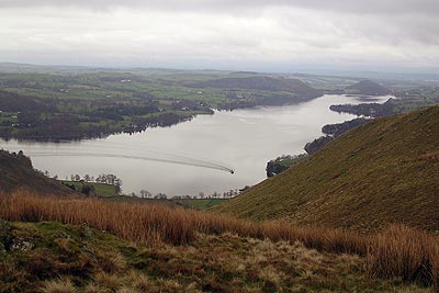
Beautiful views all around of Ullswater, Brotherswater and Hayeswater. We could see the Helvellyn hills but the tops were shrouded in mist. Carry on to Winter Crag and then drop eastwards back into Martindale passing the old church on your way back to the car.
It is a fabulous walk and to cap it off we say 4 Eagles circling overhead. The entire walk took about 7 hours and includes about 3600 feet of climb. Well worth doing!
Other walks nearby
| Walk 2039 | Gowbarrow Fell circular | moderate | 3.5 miles |
| Walk 1230 | Birks & Arnison Crag | moderate | 5.5 miles |
| Walk 1520 | Helvellyn & Fairfield Horseshoe from Patterdale | very hard | 13.0 miles |
| Walk 2047 | Place Fell | moderate | 7.5 miles |
| Walk 2425 | Boredale Circular from Patterdale | mod/hard | 11.5 miles |
| Walk 3670 | Angle Tarn and Hayeswater | moderate | 8.3 miles |
| Walk 1156 | Helvellyn via Striding Edge | hard | 9.5 miles |
| Walk 1235 | Red Tarn & Grisedale | moderate | 7.0 miles |
| Walk 1710 | Glenridding, St. Sunday Crag & Helvellyn | hard | 11.5 miles |
| Walk 3232 | Glenridding Dodd & Sheffield Pike | easy/mod | 4.5 miles |
Recommended Books & eBooks
Hadrian's Wall Path
 Hadrians Wall Path guidebook to walk the 84 mile National Trail. Described in both directions, the main description is west to east between Bowness-on-Solway and Wallsend, Newcastle, with extensions to Maryport and South Shields. With extensive historical information related to this World Heritage site and separate 1:25,000 OS map booklet included.
More information
Walking the Lake District Fells - Mardale and the Far East
 Part of the Walking the Lake District Fells series, this guidebook covers a wide range of routes to 36 Lakeland summits that can be climbed from the Ullswater, Haweswater, Troutbeck, Kentmere and Longsleddale valleys, with highlights including High Street, Place Fell and the Kentmere fells. Suggestions for longer ridge routes are also included.
More information
Messaging & Social Media
Message Walking Britain and follow the latest news.

Mountain Weather
Stay safe on the mountains with detailed weather forecasts - for iOS devices or for Android devices.