Fan Fawr & Fan Frynych, Fforest Fawr
Brecon Beacons/Bannau Brycheiniog Walk
Nat Park - Brecon Beacons - Brecon Beacons West
County/Area - Powys
Author - Hugh Maguire
Length - 6.5 miles / 10.6 km Ascent - 1900 feet / 576 metres
Time - 5 hours 10 minutes Grade - moderate
Maps 

| Ordnance Survey Explorer OL12 | Sheet Map | 1:25k | BUY |
| Anquet OS Explorer OL12 | Digital Map | 1:25k | BUY |
| Ordnance Survey Landranger 160 | Sheet Map | 1:50k | BUY |
| Anquet OS Landranger 160 | Digital Map | 1:50k | BUY |
Walk Route Description
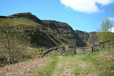
Click image to visit gallery of 5 images.
The Brecon Beacons National Park offers a range of fine walking. Some areas are busy as people are attracted the high summits of the Beacons. In contrast the area visited in this route is generally quiet with few walkers despite the excellent views across the valley to the busy Beacons.
The walk starts at the layby on the west side A470(T) Merthyr Tydfil to Brecon road at Grid ref. SN971222 located about 2 miles north of Storey Arms. Leave the car park and follow the path south west towards the craggy cliffs of Craig Cerrig-gleisiad for a short distance to a stone wall with a gate and a v-notch type of stile.
Shortly after this gate turn south, cross the stream and make your way, in a curve gradually turning to the west, up beside the crags of Craig Cerrig-gleisiad. A barbed wire fence was encountered, which we could not find a way through and eventually had to climb (note - it isn't a high fence but could prove difficult or impossible for some people).
The rest of the climb up is very steep and very hard going. I had to use the fence to pull myself up in places as my stick kept slipping on the hard slippery surface. Paths on the Ordnance Survey map are a little vague so you need to ensure that you do not get too near the cliffs. (This part of the walk is very hard and you should be reasonably fit to do it, I was a fit 55, if that helps).
On reaching the top the hard part is now over and you can turn south and head towards the summit of Fan Fawr. To the east across the A470 are views of the Brecon Beacons. The onward route to the top of Fan Fawr steepens as you get nearer the summit. From the top are some excellent views in all directions and it is a good place to stop for a break, weather permitting (We arrived in the middle of a hailstorm).
The return journey takes you due north until you reach the top of the cliffs. Then follow them around to the north west and keep going until you reach Fan Frynych. Here the views are predominantly in the northern sector across the Usk Valley to the Mynydd Epynt.
To return to the start, retrace your steps to the gate at the top of the cliffs (Grid ref. SN. 959 224). This marks the start of a very awkward and possibly dangerous path down the cliffs. Provided it is not slippery it should not be a problem for most people. Following this path eventually leads you back to the layby and the start of the walk.
Other walks nearby
| Walk 2648 | The Black Mountain, Brecon Beacons | moderate | 8.0 miles |
| Walk 3616 | Fan Fawr from Storey Arms | moderate | 6.0 miles |
| Walk 2349 | Pen Y Fan & Corn Du from near Storey Arms | moderate | 4.6 miles |
| Walk 2400 | Pen y Fan from Cwmgwdi near Brecon | moderate | 5.0 miles |
| Walk 2643 | Fan Frynych & Fan Llia, Fforest Fawr | moderate | 8.0 miles |
| Walk 1903 | Pen y Fan & Corn Du from Cwmgwdi | moderate | 7.5 miles |
| Walk 2074 | Highest Peaks of the Brecon Beacons | mod/hard | 11.0 miles |
| Walk 2645 | Fan Gyhirych & Fan Bwlch Chwyth, Fforest Fawr | moderate | 8.0 miles |
| Walk 2646 | Fan Nedd & Fan Bwlch Chwyth, Fforest Fawr | moderate | 7.0 miles |
| Walk 2647 | Fan Gyhirych, Fan Nedd & Fan Bwlch Chwyth | moderate | 10.0 miles |
Recommended Books & eBooks
Walking on the Brecon Beacons
 45 circular day walks are described in this guidebook to the Brecon Beacons National Park. From west to east, Mynydd Du, Fforest Fawr, the Brecon Beacons and the Black Mountains these mountain and valley routes offer many options, highlighting the natural features. The walks described explore dramatic waterfalls, wooded gorges and upland valleys.
More information
Walking in Carmarthenshire
 Guidebook to 30 walking routes (2 to 10 miles) in Carmarthenshire, south Wales, including sections of Carmarthenshire Coast Path. Walks for all abilities, including coastal, river, forest and hill walks in Cambrian Mountains, Tywi Valley, Y Mynydd Du (Black Mountains) and Brecon Beacons. Easy access from Bristol, Cardiff and Swansea.
More information
Messaging & Social Media
Message Walking Britain and follow the latest news.

Mountain Weather
Stay safe on the mountains with detailed weather forecasts - for iOS devices or for Android devices.