Fan Frynych & Fan Llia, Fforest Fawr
Brecon Beacons/Bannau Brycheiniog Walk
Nat Park - Brecon Beacons - Brecon Beacons West
County/Area - Powys
Author - Hugh Maguire
Length - 8.0 miles / 13 km Ascent - 1700 feet / 515 metres
Time - 5 hours 40 minutes Grade - moderate
Maps 

| Ordnance Survey Explorer OL12 | Sheet Map | 1:25k | BUY |
| Anquet OS Explorer OL12 | Digital Map | 1:25k | BUY |
| Ordnance Survey Landranger 160 | Sheet Map | 1:50k | BUY |
| Anquet OS Landranger 160 | Digital Map | 1:50k | BUY |
Walk Route Description
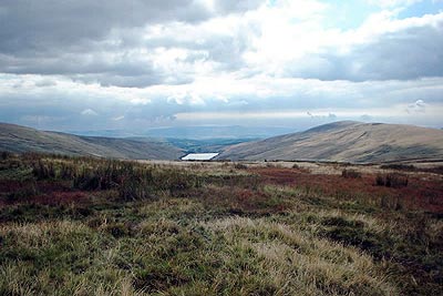
Click image to visit gallery of 3 images.
The less frequented places within our National Parks still offer solitude amid dramatic surroundings. The Brecon Beacons National Park, with its many popular "honeypots", does offer many hills that see few walkers and where you can still get away from the crowds. This walk, assisted by limited parking opportunities, offers just that.
This walk starts at the junction with the nameless road and the old Roman road "Sarn Helen" at grid ref. SN925185 between Fan Llia and Fan Nedd. There is usually enough space for several cars to park here.
Follow Sarn Helen north east. It is rough in places and has streams flowing across it. In very wet weather it almost becomes a stream itself. After about 2.5 miles there is a loop in the track and a small bridge crosses a stream (Nant Cwm Du)flowing from a small valley to the east.
Turn right here and follow the track east alongside this stream untill you are directed upwards by a sign. There follows a steep climb up a very boggy hillside as you make your way to the top of Fan Frynych (this is the only really difficult part of this walk). Take a break and enjoy the views to the east over the Brecon Beacons.
Turn south and walk around the head of the valley before turning south west whilst keeping to the high ground. You can now follow the ridge above the Ystradfellte Resevoir, for about 3 miles, via Fan Dringarth, to the cairn just below the top of Fan Llia. From here turn west and walk downhill to the starting point.
Other walks nearby
| Walk 2645 | Fan Gyhirych & Fan Bwlch Chwyth, Fforest Fawr | moderate | 8.0 miles |
| Walk 2646 | Fan Nedd & Fan Bwlch Chwyth, Fforest Fawr | moderate | 7.0 miles |
| Walk 2647 | Fan Gyhirych, Fan Nedd & Fan Bwlch Chwyth | moderate | 10.0 miles |
| Walk 2641 | Fan Fawr & Fan Frynych, Fforest Fawr | moderate | 6.5 miles |
| Walk 3616 | Fan Fawr from Storey Arms | moderate | 6.0 miles |
| Walk 3205 | Carnau Gwynion from Ystradfellte | easy | 4.0 miles |
| Walk 3206 | Ystradfellte Waterfalls Walk | moderate | 9.2 miles |
| Walk 2349 | Pen Y Fan & Corn Du from near Storey Arms | moderate | 4.6 miles |
| Walk 2648 | The Black Mountain, Brecon Beacons | moderate | 8.0 miles |
| Walk 3563 | Fan Brycheiniog and Picws Du | moderate | 7.1 miles |
Recommended Books & eBooks
Walking in Carmarthenshire
 Guidebook to 30 walking routes (2 to 10 miles) in Carmarthenshire, south Wales, including sections of Carmarthenshire Coast Path. Walks for all abilities, including coastal, river, forest and hill walks in Cambrian Mountains, Tywi Valley, Y Mynydd Du (Black Mountains) and Brecon Beacons. Easy access from Bristol, Cardiff and Swansea.
More information
Walking on the Brecon Beacons
 45 circular day walks are described in this guidebook to the Brecon Beacons National Park. From west to east, Mynydd Du, Fforest Fawr, the Brecon Beacons and the Black Mountains these mountain and valley routes offer many options, highlighting the natural features. The walks described explore dramatic waterfalls, wooded gorges and upland valleys.
More information
Messaging & Social Media
Message Walking Britain and follow the latest news.

Mountain Weather
Stay safe on the mountains with detailed weather forecasts - for iOS devices or for Android devices.