Lacock - a village stroll
Wiltshire Walk
County/Area - Wiltshire
Author - Lou Johnson
Length - 1.0 miles / 1.6 km Ascent - 25 feet / 8 metres
Time - 0 hours 30 minutes Grade - easy
Maps 

| Ordnance Survey Explorer 156 | Sheet Map | 1:25k | BUY |
| Anquet OS Explorer 156 | Digital Map | 1:25k | BUY |
| Ordnance Survey Landranger 173 | Sheet Map | 1:50k | BUY |
| Anquet OS Landranger 173 | Digital Map | 1:50k | BUY |
Walk Route Description
Click image to visit gallery of 9 images.
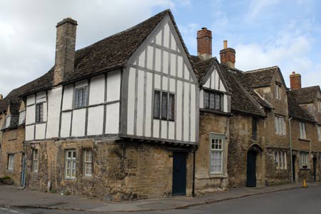
Lacock was once a busy town. Today it feels more like a village with a few shops, a number of pubs and restaurants and of course Lacock Abbey. The National Trust own much of the village and Lacock Abbey so it is likely to be well protected from modernisation. Fox-Talbot, one of the great pioneers of photography, lived in the village and there is a museum featuring his work.
This short stroll provides an introduction to the village and hopefully provides a photographic impression of what you will see. The start is the National Trust pay and display car park (grid ref. ST918682) signed from the A350 Chippenham to Melksham road.
Exit the car park and follow the footpath into the village. Passing the entrance to Lacock Abbey (which could also be included in this stroll), the path leads you into High Street, where apart from cars, you are immediately transported back to another age and it becomes clear why the village is used in so many period films. The attractive houses and shops are not museum pieces but people's homes and businesses so please treat them with respect. Continue along High Street to the T-junction.
Turn right into West Street and continue north to the next junction. Turn right into Church Street and continue to St Cyriac's parish church at the eastern end of the village. This 15th church has an interesting interior and is worth a visit. After exploring the church return the way you came and turn first left into East Street. At the end of this street on the left hand side you will see the lock-up and the beautiful tithe barn which is being restored.
To return to the car park, turn left and follow the road back to the start.
Other walks nearby
| Walk 3347 | Ford & North Wraxall from Castle Combe | easy/mod | 8.0 miles |
| Walk 1891 | Solsbury Hill from Northend | easy | 3.0 miles |
| Walk 2266 | Westbury White Horse Circular | easy | 3.6 miles |
| Walk 2804 | Bath to Keynsham over Kelston Round Hill | easy/mod | 9.0 miles |
| Walk 2255 | Urchfont Hill from Market Lavington | easy/mod | 8.6 miles |
| Walk 2812 | Avebury, West Kennett and Silbury Hill | easy/mod | 7.0 miles |
| Walk 3417 | Silbury Hill and West Kennett Long Barrow from Avebury | easy | 3.0 miles |
| Walk 3318 | Hackpen Hill & Overton Down | easy/mod | 9.5 miles |
| Walk 2377 | Highlights of Avebury | easy/mod | 8.8 miles |
| Walk 2087 | The Cam Brook Valley from Southstoke | easy | 5.5 miles |
Recommended Books & eBooks
The Kennet and Avon Canal
 Guidebook to walking along the Kennet & Avon Canal. The 94 mile route from Reading to Bristol is split into 7 stages of fairly easy walking and includes the UNESCO World Heritage Site of Bath and Bristol's Floating Harbour. 20 circular walks are also included, ranging from 4¼ to 9 miles, taking in the best sections of the canal.
More information
Messaging & Social Media
Message Walking Britain and follow the latest news.

Mountain Weather
Stay safe on the mountains with detailed weather forecasts - for iOS devices or for Android devices.