Carsington, Brassington & Cromford and High Peak Railway from Middleton
Derbyshire Walk
County/Area - Derbyshire - South East Derbyshire
Author - Lou Johnson
Length - 9.5 miles / 15.4 km Ascent - 1400 feet / 424 metres
Time - 6 hours 10 minutes Grade - moderate
Maps 

| Ordnance Survey Explorer OL24 | Sheet Map | 1:25k | BUY |
| Anquet OS Explorer OL24 | Digital Map | 1:25k | BUY |
| Ordnance Survey Landranger 119 | Sheet Map | 1:50k | BUY |
| Anquet OS Landranger 119 | Digital Map | 1:50k | BUY |
Walk Route Description
Click image to visit gallery of 9 images.
This Derbyshire walk explores part of the Cromford and High Peak Railway together with two attractive villages. Rather surprisingly the route remains completely outside the boundaries of the Peak District National Park.
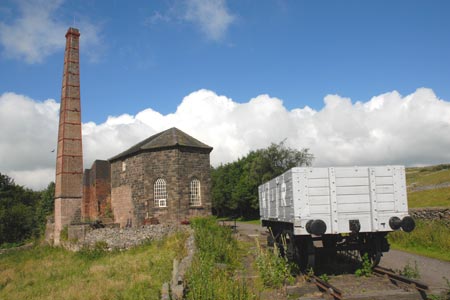
The start is the car park at the Middleton Top Visitor Centre (Grid ref. SK275551) where there is an honesty box for parking fees. Refreshments, toilets and bike hire are available. Before starting the walk it is worth walking east to inspect the winding house and incline that was used to bring railway wagons up from Cromford in the Derwent Valley to the line across the Derbyshire uplands. The whole route of this fascinating railway, which closed in 1967, has now been converted to a trail used by walkers, cyclists and horses.
After satisfying your curiosity about the incline, walk west along the former trackbed of the railway. The track is well graded, although the railway had the steepest (1 in 14) gradients worked by adhesion in Britain. The way ahead is obvious and you continue through a tunnel before starting to climb up Hopton Incline (1 in 14). At the top the trail crosses a works access road. Leave the old railway here and cross the adjacent road to locate a footpath sign (Grid ref. SK250546) pointing south to "Carsington". Take this path. Keeping the field boundary on your left, the path descends before a short ascent after which you get a fine view of Carsington Reservoir. Look out for the King's Chair on your left. This rather interesting limestone outcrop is exactly what it says - a large chair shaped from rock!
The path reaches the boundary to woodland. Do not enter the wood but turn sharp right and follow the marker posts down the steep grassy hillside. The path becomes clearer as you descend and leads into a narrow alley. This in turn takes you between cottages to a road. Turn right, following a tarmac lane. Reaching the end of the land, continue through the gate along a grassy track. Follow this path climbing onto the flanks of Carsington Pasture before passing through a squeeze stile (with no wall on either side) to reach a lane (Grid ref. SK238539). Cross the lane and go through the gate opposite and follow the track for a short way. The path forks left off the track (the farmer has erected a sign) and this leads you down into the village of Brassington.
Walk through the village to the parish Church. Go through the main gate and walk past the church bearing right at the boundary wall to climb up to a lane. Turn left along the lane and look out for the path on your right. There are in fact two paths which soon join. The first is not signed but the second is. Take either of these paths and continue through a pasture to reach a green lane. Turn left down the lane. At the first stile on your right (Grid ref. SK224545) enter the field and aim for the outcrop of Rainster Rocks. Keep to the left of the first smaller rock out crop and cross a stile before continuing on the clear path to the top of Rainster Rocks. This is a perfect place for a rest with good views south into the National Park.
Return down the way you came turning left onto a path before reaching the stile in the fence crossed earlier. Stay on this path uphill before dropping down to a derelict farm (Grid ref SK221552). Just past the buildings taken turn right and follow the path around the boundary of the farm. Turn left (east) on an unsigned path (marked on the OS map) that leads up to a lane (Grid ref. SK229550) above Brassington. Turn left along the lane for just over 200 metres. Take the signed footpath on the right through riding stables and turn right onto the Cromford and High Peak Trail.
The remainder of the route requires no explanation as you follow the track back to Middleton Top. On the way you past Harboro Rocks on your left, where the crags offer some good rock climbs. Descending Hopton Incline, it will come as no surprise that steam locomotives often had to try three or four times to get up the incline with their loaded trains. Entering the tunnel there is less than a mile to go back to the start.
Other walks nearby
| Walk 2701 | Harboro Rocks & Brassington | easy/mod | 6.5 miles |
| Walk 2627 | Cromford to Bakewell | moderate | 11.5 miles |
| Walk 2899 | Cromford Canal & Black Rocks from High Peak Junction | easy/mod | 6.8 miles |
| Walk 1378 | Carsington Circular | easy | 4.5 miles |
| Walk 1379 | Carsington and Harboro Rocks | easy/mod | 5.8 miles |
| Walk 2218 | Cocking Tor from near Matlock | moderate | 9.5 miles |
| Walk 3672 | Carsington Water, Hognaston & Madge Hill | easy/mod | 5.5 miles |
| Walk 2559 | Stanton Moor & The Nine Ladies Stones from Winster | moderate | 9.0 miles |
| Walk 3196 | Stanton Moor and Robin Hood's Stride from Winster | easy/mod | 7.0 miles |
| Walk 2136 | Wensley & Brightgate | easy/mod | 6.2 miles |
Recommended Books & eBooks
Walking in Derbyshire
 Walking guidebook to 60 circular day walks in Derbyshire and the Peak District. Includes the Derwent, Wye and Trent river valleys, near Derby, Matlock, Glossop, Bakewell and Ripley. Routes range from easy to moderate and are between 4 and 14km (2 to 10 miles). Walks focus on places of interest, from Stone Age forts to castles to grand estates.
More information
Walking in the Peak District - White Peak East
 Guidebook describing 42 half-day and day walks in the limestone landscapes of Derbyshire's White Peak, part of the Peak District National Park. One of two volumes, this book covers the east of the region, with potential bases including Bakewell, Eyam, Castleton, Birchover, Matlock and Wirksworth.
More information
Messaging & Social Media
Message Walking Britain and follow the latest news.

Mountain Weather
Stay safe on the mountains with detailed weather forecasts - for iOS devices or for Android devices.