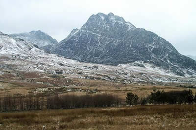
Tryfan North Ridge from Ogwen Valley
Snowdonia/Eryri Walk
Nat Park - Snowdonia - Glyders Tryfan
County/Area - Conwy
Author - Lou Johnson
Length - 3.5 miles / 5.7 km Ascent - 1900 feet / 576 metres
Time - 3 hours 40 minutes Grade - hard
Maps 

| Ordnance Survey Explorer OL17 | Sheet Map | 1:25k | BUY |
| Anquet OS Explorer OL17 | Digital Map | 1:25k | BUY |
| Ordnance Survey Landranger 115 | Sheet Map | 1:50k | BUY |
| Anquet OS Landranger 115 | Digital Map | 1:50k | BUY |
Walk Route Description
Click image to see photo description.
This Snowdonia (Eryri) walk and scramble starts from Gwern Gof Uchaf (Grid ref. SH672604), where parking and camping is available for a small charge. Alternatively you can park on the side of the A5 close by. The route chosen is the hardest of the "walkers" routes to the summit of Tryfan and before starting this route you should make sure it is within your capabilities. The route description is based on a summer ascent. However notes on completing the route in winter conditions have been added at the end of the description.
In summer the route can be quite daunting for walkers with little experience and plenty of time should be allowed as it will take much longer than anticipated. It must be stressed that there is very little actual walking involved in the ascent and part of the descent and you must be aware that much of the time will be spent scrambling.
From Gwern Gof Uchaf follow the path that skirts the western flank of Tryfan Bach where you will probably see climbers learning the basic skills. The path climbs steadily to reach a fence (Grid ref. 669599). Turn right alongside this fence and climb further to reach the start of the "Heather Terrace", which will be used for the descent. Continue upwards ignoring the Terrace gaining height to reach Tryfan's north ridge.
There now follows nearly a thousand feet of scrambling. There are easy routes over almost all of the ascent with the option of harder routes for those who enjoy extra thrills or challenges. It is hard to describe the precise route although mostly it is obvious through heavy use.
The scramble is tiring even for those with reasonable levels of fitness and at times you may feel that you have achieved no height gain. When arriving to start the walk you may have noticed a large rock sticking out from the north ridge. This is "the Canon" and when reached provides an indication that you have made some progress. Passing the Canon you still have a fair way to go and progress may slow as the scrambling gets more intensive. Eventually you reach the summit and are rewarded with a superb view in all directions.
Head south off the summit. Shortly after starting the descent you go close to the top of the South Gully, which is one of the climber's routes to the summit. Under normal conditions there is a little exposure as you pass the top of this precipitous gully but nothing too hairy. If in doubt sit down and scuttle across on your bottom! From here there is a short re-ascent to the South Summit before the descent continues with plenty of scrambling. With a wide choice of routes you can get in a tangle and may have to re-ascend to find an easier way down.
Reaching the distinct col, with the Far South summit ahead, turn left down grassy scree to reach the "Heather Terrace". Locating the Heather Terrace path is quite difficult and you may have to hunt around to find the path, which descends gradually across the east face of Tryfan. Assuming you have been successful continue down the terrace to reach the fence. Cross the fence and turn right before retracing your steps down past Tryfan Bach to reach the start. Note - if you are unsuccessful finding the "Heather Terrace" the continue on down the slope to the valley below and turn left on the valley path. This brings you out near to Tryfan Bach.
Winter Route Description - Tryfan with snow and ice can be difficult and it is important that you choose your day. In these condition it is essential that you have adequate equipment and you are aware of the hazards that may be encountered. You should also be prepared to turn back if the going gets too tough. You should also have some experience of an ascent in winter conditions to the summit of an easier peak and preferably climbed Tryfan by the same route in summer.
After snowfall and a sharp overnight frost the biggest problem was snow-melt, which had re-frozen into sheet ice. Most was avoidable and caused no major problems. However this could have been much worse and crampons and ice-axe are recommended.
With no snow on the ground the route is clear for the full ascent however under snow care needs to be taken that you select the right approach. There were areas with snow drifts, which concealed some of the route. They also made it hard to judge what lay between the large blocks of rock.
The summit area was very slippery with a thin layer of ice coating virtually every rock. Extreme care was needed especially crossing the top of South Gully. This was probably the "hairiest" moment of the day!
The descent from the col to the "Heather Terrace" was also lethal in places with ice covered by a thin layer of snow. The best route was keeping well to the right on this descent.
Other walks nearby
| Walk 2820 | Carneddau traverse from Llyn Ogwen | mod/hard | 14.0 miles |
| Walk 1232 | Carnedd Llewelyn, Llyn Eigiau & Llyn Cowlyd | hard | 16.0 miles |
| Walk 2855 | Gallt yr Ogof & Braich y Ddeugwm | moderate | 4.0 miles |
| Walk 3056 | Pen yr Helgi Du from Ogwen Valley | moderate | 5.5 miles |
| Walk 2650 | Tryfan, the Glyders & Y Garn | very hard | 8.0 miles |
| Walk 1088 | Glyder Ridge traverse | hard | 5.5 miles |
| Walk 1186 | Y Garn | mod/hard | 4.5 miles |
| Walk 3019 | Y Garn & Carnedd y Filiast Ogwen Cottage | hard | 8.5 miles |
| Walk 3062 | Pen yr Ole Wen | moderate | 5.0 miles |
| Walk 2417 | Glyder Fach, Glyder Fawr and Tryfan from Idwal Cottage | mod/hard | 6.5 miles |
Recommended Books & eBooks
Snowdonia: 30 Low-level and easy walks - North
 Guidebook describing 30 walks in Snowdonia, Wales. Routes are mostly low level and on clear paths and showcase the region's beautiful scenery and rich history and culture. Part of a 2-volume set, this northern volume includes the Snowdon area, the Ogwen and Conwy Valleys, Betws-y-Coed, Beddgelert, Ffestiniog and the coast.
More information
Great Mountain Days in Snowdonia
 Inspirational guidebook to 40 great mountain day walks and scrambles in Snowdonia. Inspirational routes for all abilities across the National Park with routes up Snowdon and Moel Eilio, the Glyderau, the Carneddau, Eifionydd, Siabod and the Moelwynion, Rhinogydd (the Harlech Dome), Migneint and the Arans and Cadair Idris and the Tarrens.
More information
Messaging & Social Media
Message Walking Britain and follow the latest news.

Mountain Weather
Stay safe on the mountains with detailed weather forecasts - for iOS devices or for Android devices.