Dufton Pike from Dufton
North Pennines Walk
Region - North Pennines
County/Area - Cumbria - North Pennines
Author - Lou Johnson
Length - 5.5 miles / 8.9 km Ascent - 1250 feet / 379 metres
Time - 4 hours 0 minutes Grade - easy/mod
Maps 

| Ordnance Survey Explorer OL19 | Sheet Map | 1:25k | BUY |
| Anquet OS Explorer OL19 | Digital Map | 1:25k | BUY |
| Ordnance Survey Landranger 91 | Sheet Map | 1:50k | BUY |
| Anquet OS Landranger 91 | Digital Map | 1:50k | BUY |
Walk Route Description
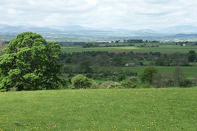
Click image to visit gallery of 3 images.
This short circular walk starts from the attractive village of Dufton and follows the Pennine Way north before ascending Dufton Pike from where excellent views are reward for the effort required for the ascent. Dufton Pike takes a conical form when viewed from many directions and provides a convenient landmark in this part of the Vale of Eden.
The start is the village of Dufton where there is small car park adjacent to the public conveniences (Grid ref. NY689250). Exit the car park and turn left and the follow the road through the village towards Knock. Just after the road turns right to leave the village take the farm track that forks right (Grid ref. NY 688 253). This leads north with the Pennine Way joining from the right to reach Coatsike Farm.
Continue north on the Pennine Way (Hurning Lane) to Halsteads. Just beyond here the track descends to cross Great Runsdale Beck at a gate. Just before the gate take the right hand grassy path (Grid ref. NY692273). You soon enter "Open Access" at a wall. Just beyond here go half right and head for the path that can be seen on the hillside ahead. This leads without further problem to the summit of Dufton Pike.
Because Dufton Pike is a solitary hill the views in all directions are worthwhile with the main Pennine ridge in view to the east and the Lakeland Fells visible across the Vale of Eden to the west. To continue descend by the clear path leaving the summit to the south-west. This leads down to a lane. Turn right and follow this track back to Dufton.
Note - The ascent of Dufton Pike described above does not involve any trespass. However there is a more direct path that starts before open access countryside is reached but this is not a public right of way.
Other walks nearby
| Walk 1715 | Dufton Pike & Dufton | easy | 5.0 miles |
| Walk 1784 | Rutter Force & Hoff Beck | easy/mod | 8.0 miles |
| Walk 3071 | Cross Fell & Great Dun Fell from Kirkland | mod/hard | 12.0 miles |
| Walk 3274 | Cronkley Scar & Cauldron Snout | moderate | 8.0 miles |
| Walk 1683 | High Cup Nick & Cow Green Reservoir | moderate | 12.8 miles |
| Walk 3336 | Cauldron Snout | easy | 3.6 miles |
| Walk 3593 | Meldon Hill from Cow Green Reservoir | moderate | 9.2 miles |
| Walk 2453 | Askham Fell from Lowther Castle | easy/mod | 7.4 miles |
| Walk 3758 | Tynehead and Ashgill Force from near Garrigill | easy/mod | 8.2 miles |
| Walk 1084 | Garrigill, Alston & Nenthead | moderate | 13.1 miles |
Recommended Books & eBooks
Walking the Lake District Fells - Buttermere
 Part of the Walking the Lake District Fells series, this guidebook covers a wide range of routes to 32 Lakeland summits that can be climbed from the Buttermere, Lorton and Newlands valleys, with highlights including Haystacks, High Stile, Grasmoor and the fells of the Coledale Round. Suggestions for longer ridge routes are also included.
More information
Hadrian's Wall Path
 Hadrians Wall Path guidebook to walk the 84 mile National Trail. Described in both directions, the main description is west to east between Bowness-on-Solway and Wallsend, Newcastle, with extensions to Maryport and South Shields. With extensive historical information related to this World Heritage site and separate 1:25,000 OS map booklet included.
More information
Messaging & Social Media
Message Walking Britain and follow the latest news.

Mountain Weather
Stay safe on the mountains with detailed weather forecasts - for iOS devices or for Android devices.