Great Rhos & the Radnor Forest from New Radnor
Powys Walk
County/Area - Powys - Powys Central
Author - Lou Johnson
Length - 9.0 miles / 14.6 km Ascent - 1750 feet / 530 metres
Time - 6 hours 20 minutes Grade - moderate
Maps 

| Ordnance Survey Explorer 200 | Sheet Map | 1:25k | BUY |
| Anquet OS Explorer 200 | Digital Map | 1:25k | BUY |
| Ordnance Survey Explorer 201 | Sheet Map | 1:25k | BUY |
| Anquet OS Explorer 201 | Digital Map | 1:25k | BUY |
| Ordnance Survey Landranger 148 | Sheet Map | 1:50k | BUY |
| Anquet OS Landranger 148 | Digital Map | 1:50k | BUY |
Walk Route Description
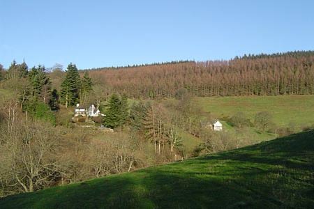
Click image to visit gallery of 12 images.
Mid-Wales offers much for walkers and this particular route is one of the best including three summits over 2000 feet. Like much of the area the paths see few people and you could well complete the circuit without meeting anyone else. There are sections that would be hard to navigate in low cloud and there are also a few areas where the going could be muddy after rain.
Park on the street in the small town of New Radnor taking care not to obstruct anyone's access. Locate the only major junction in the town centre and take the lane that heads roughly north (Mutton Dingle). Follow this lane for about 200 metres and fork right along a track. The gentle climb leads you alongside a wood with rounded Knowle Hill to your right. Just over the summit of the col locate a narrow path that heads into the wood. This leads to a forest track. The trees were being felled in this area so the onward path may be hard to follow but you need to exit the wood by a gate at the most northern point of the plantation.
Reaching open land take the left fork through a gate and follow a path across the moor. If you are into peak bagging then a short diversion right to the summit of Bache Hill is necessary otherwise stay on the main path and descend to the corner of a forested area (grid ref. 205638). The onward route climbs out of a small valley to head northwest across the moor to the summit of Black Mixen, which is home to an unsightly mast.
Continue from the summit in a north-westerly direction to head for the forest boundary (grid ref. 190650). If the visibility is good keep as far to the left as possible following a narrow path along the top of the deep valley of Harley Dingle. This way you get the best views of the rocky outcrops that fringe the eastern side. Reaching the forest boundary turn west and stay on the moorland side of the fence for about a kilometre to reach an eroded track that exits the woods. Turn left along this for about two hundred metres before turning left again along a narrow path that makes for the summit of Great Rhos. This is the highest point on the walk although the view is not the best!
Continue south on a narrow path and keep trending to the left (without trespassing on the range) until the main bridlepath descending into Harley Valley is reached after a shallow valley. Follow this down to the stream below. In a short way you pick up a more substantial path which meanders high above the stream to reach a wider track. This leads south east to the col between Fron Hill and Great Rhos. The views from this col are the best of the walk and the gradual descent into Harley Dingle provides a superb end to this route. Reaching the stream on the valley floor cross the footbridge and take the left-hand fork which leads you back through a wood and fields to New Radnor.
Other walks nearby
| Walk 3565 | The Hergest Ridge from Gladestry | easy/mod | 6.1 miles |
| Walk 3643 | LLan-fawr & Lugg Valley from Whitton | moderate | 7.5 miles |
| Walk 3614 | Herrock Hill from Kington | moderate | 8.0 miles |
| Walk 3285 | The Hergest Ridge and Huntington from Kington | moderate | 12.0 miles |
| Walk 3300 | The Hergest Ridge from Kington | moderate | 8.5 miles |
| Walk 3631 | Panpunton Hill & Stowe from Knighton | moderate | 7.8 miles |
| Walk 2816 | Kinsley Wood, Stowe and Offa's Dyke | moderate | 12.0 miles |
| Walk 1907 | Stowe & Offa's Dyke from Kinsley Wood | moderate | 7.0 miles |
| Walk 1998 | Harley's Mountain from Lingen | easy/mod | 7.5 miles |
| Walk 3253 | Warren Hill, Gors Lydan & Moelfre Hill | easy/mod | 6.0 miles |
Recommended Books & eBooks
The Cambrian Way
 Guidebook to the Cambrian Way, a challenging three-week mountain trek through Wales from Cardiff to Conwy. The 470km un-waymarked route is presented from south to north. Often sticking to long, beautiful ridgelines, it crosses wild and rugged terrain and visits many of Wales's highest mountains, including Snowdon.
More information
Messaging & Social Media
Message Walking Britain and follow the latest news.

Mountain Weather
Stay safe on the mountains with detailed weather forecasts - for iOS devices or for Android devices.