Cadair Berwyn from Cwm Maen Gwynedd
Powys Walk
County/Area - Powys - Powys North
Author - Lou Johnson
Length - 9.3 miles / 15 km Ascent - 2275 feet / 689 metres
Time - 6 hours 50 minutes Grade - moderate
Maps 

| Ordnance Survey Explorer 255 | Sheet Map | 1:25k | BUY |
| Anquet OS Explorer 255 | Digital Map | 1:25k | BUY |
| Ordnance Survey Landranger 125 | Sheet Map | 1:50k | BUY |
| Anquet OS Landranger 125 | Digital Map | 1:50k | BUY |
Walk Route Description
Click image to visit gallery of 4 images.
The Berwyns have a reputation for being boring with miles of heather and little rock. The highest peak of the range is an exception and considering its height (2723ft / 830m) it sees very few visitors. With steep rocky escarpments facing east it provides the basis for an interesting walk. The usual route to the summit starts at the beautiful waterfall of Pistyll Rhaeadr, which is a popular spot for visitors in the summer. From here walkers head north along the valley to the shores of Llyn Lluncaws and follow the southern rim of the cwm to the summit.
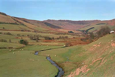
The route chosen for this walk is longer and less popular starting from the Tyn-y-ffridd farm in Cwm Maen Gwynedd (grid ref. SJ117308). Parking is restricted and you may have to park further back down the road. However visitors in this area are few and on the best day of March 1999 I only saw one other walker all day!
From the farm head up the track that runs north. Where this turns right follow the public right of way that leads to the southern corner of the conifer plantation. All that is required now is a 600ft climb on grass beside the plantation to the first summit of the day - Mynydd Tarw. From here there are good views east towards Shropshire and Cheshire as well as a preview of the remaining parts of the walk.
Turning north east, follow the fence to reach Foel Wen south top. As you continue west the view across to Cadair Berwyn improves with some interesting spiky crags adding interest to the foreground. With the rock covered by thick layers of peat, the going is fairly straight forward although a little squelchy in places. Keeping with the fence you soon reach the main top of Foel Wen.
The third summit of the round is Tomle, with a steady climb of 650ft to its summit. You are now in a perfect position to inspect the crags of Cadair Berwyn, which extend over a distance of more than two miles. The final climb of the day is obvious as you follow the steepening path on to the summit plateau.
Keeping as close to the crags as conditions permit, you have a good lofty walk to the twin summits of Cadair Berwyn. Down to your left is the beautiful valley Cwm Maen Gwynedd where you started. To your right (if conditions permit) you can see across the whole of Snowdonia (Eryri) to Snowdon, the Glyders and the Carneddau.
The summit rocks are an ideal place to spend some time absorbing the view before starting the return walk base to your car. Heading south from Cadair Berwyn, you descend to a col. From here there is an excellent view of Llyn Lluncaws and the valley leading to Pistyll Rhaeadr. Look out for a path heading down to Moel yr Ewig. It is difficult to spot and care needs to be exercised as the crags are steep. Once located make for the fence running south east, a direction you will follow over Moel yr Ewig and onto Godor. At times the going is boggy but the sketchy path keeps to dry ground for most of the route.
The descent to the valley is a problem. No rights of way are marked on maps although the ridge path obviously sees enough traffic during the year. From Godor I headed south-east until I reached the public right of way just to the west of Bryn-gwyn farm. From here it is a matter of keeping to the track (right of way) back to your car.
For those interested in "peak bagging" and if time and energy permit, you can make the short detour to the summit of Moel Sych before descending to Moel yr Ewig. The view is similar to that from Cadair Berwyn although the southern perspective over mid-Wales is better.
Other walks nearby
| Walk 1989 | Llanarmon Dyffryn Ceiriog Circular | moderate | 6.0 miles |
| Walk 1086 | Post Gwyn and Craig-y-Mwn from Pistyll Rhaeadr | moderate | 6.5 miles |
| Walk 3053 | Berwyn Tops from Tan Y Pystyll | moderate | 14.0 miles |
| Walk 1256 | Cadair Bronwen | moderate | 9.5 miles |
| Walk 1845 | Castell Dinas Bran from Llangollen | easy/mod | 4.0 miles |
| Walk 3102 | Bwlch Sych and Tynygarreg from Lake Vyrnwy | moderate | 8.5 miles |
| Walk 3655 | Rhewl, Moel y Gamelin & Moel Morfydd | moderate | 5.4 miles |
| Walk 1067 | Ruabon Mountain & The Limestone Edges of Llangollen | moderate | 11.0 miles |
| Walk 2388 | Chirk Castle & Ceiriog Valley | easy/mod | 6.0 miles |
| Walk 2598 | Ruabon Mountain, World's End & Panorama Circular | moderate | 12.5 miles |
Recommended Books & eBooks
The Cambrian Way
 Guidebook to the Cambrian Way, a challenging three-week mountain trek through Wales from Cardiff to Conwy. The 470km un-waymarked route is presented from south to north. Often sticking to long, beautiful ridgelines, it crosses wild and rugged terrain and visits many of Wales's highest mountains, including Snowdon.
More information
Messaging & Social Media
Message Walking Britain and follow the latest news.

Mountain Weather
Stay safe on the mountains with detailed weather forecasts - for iOS devices or for Android devices.