Snowdon via Crib Goch from Pen-y-pass
Snowdonia/Eryri Walk
Nat Park - Snowdonia - Snowdon Crib Goch
County/Area - Gwynedd
Author - Lou Johnson
Length - 8.5 miles / 13.8 km Ascent - 2855 feet / 865 metres
Time - 7 hours 10 minutes Grade - very hard
Maps 

| Ordnance Survey Explorer OL17 | Sheet Map | 1:25k | BUY |
| Anquet OS Explorer OL17 | Digital Map | 1:25k | BUY |
| Ordnance Survey Landranger 115 | Sheet Map | 1:50k | BUY |
| Anquet OS Landranger 115 | Digital Map | 1:50k | BUY |
Walk Route Description
Click image to visit gallery of 12 images.
The Snowdon Horseshoe is perhaps the greatest ridge walk in Snowdonia (Eryri) and for many the highlight is a traverse of Crib Goch's arete. This walk is a linear route combining the first half of the Snowdon Horseshore over Crib Goch with a descent to Llanberis. To return to Pen-y-pass you need to use the Sherpa bus service. It is worth checking the bus times before you leave Pen-y-pass as it is a long walk back if you miss the last service! For those wishing to complete the horseshoe then use this route as far as Snowdon's summit and then return to Pen-y-pass by completing the outward half of Walk 1216 in reverse.
Much has been written about Crib Goch. On a bad day it can be lethal especially in high winds or under snow and ice. If the weather is benign then it should present no problems to an agile person who has experience of mountain walking. However a word of warning. This is not a mountain for the beginner.
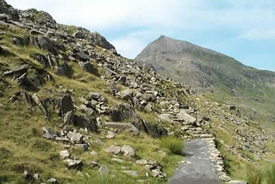
This Snowdonia (Eryri) walk starts from Pen-y-pass at the top the Llanberis Pass (grid ref SH647555). The car parking here fills quite early especially in fine weather so an early arrival is recommended. Leave the car-park by the northern exit alongside the cafe and follow the Pyg Track as it climbs steadily to Bwlch y Moch. You soon get a superb view of Crib Goch probably with people already clambering up its east ridge. At Bwlch y Moch leave the Pyg Track and take the path that forks right. It is surprising how many people head for Crib Goch thinking its Snowdon so you may be in the company of families with small children at this stage!
The first section of path from Bwlch y Moch has been paved but only until you reach steeper ground. This is where the families realise their mistake and return to the Pyg Track. The slope becomes rockier and the path twists and turns with the occasional short sections of scrambling. The obvious route may appear too difficult but with care you can select an easier route on all sections of this walk. The most difficult scrambling is roughly two-thirds of the way to the top. Once this has been overcome the remainder of the climb is relatively easy and you soon find yourself perched on the rocks at the eastern end of the ridge. This is not the summit, which is located further along the ridge that stretches ahead.
Your selected route along the ridge depends on your nerve. There is a feeling of exposure especially to your right although this can be avoided by taking a lower line to your left. The best route in good weather is along the crest and providing you take care you will soon arrive at the highest point. From here the ridge descends to the pinnacles. The best route is to the left following a lower well worn route marked with cairns. Bwlch Coch is reached with Crib Goch completely conquered.
Ahead lies an interesting, but easier, traverse of Crib y Ddysgl. Of similar character to Crib Goch there is one section of scrambling that might cause problems if you don't discover the easy route. Otherwise it is straightforward with superb views all the way to the summit of Garnedd Ugain. Only 20 metres shorter than Snowdon this mountain deserves better acclaim as many people completely ignore it on their way to Snowdon. Descend from Garnedd Ugain in a south-westerly direction to reach the railway. Follow this, and the crowds, to Snowdon's Summit passing the large stone that marks the upper exit of the Pyg Track. (Note - this track can also be used for descent to Pen-y-pass.)
The onward route selected for this walk is the Llanberis Path. Often described as the easiest route of ascent it also offers an easy route down. Leave the summit and retrace your steps following the railway down hill. The path skirts the northern slopes of Garnedd Ugain to reach Clogwyn Station. Rather than follow the main path keep to the right of the railway and head across grass to the delightful rocky summit of Llechog. You are unlikely to be interrupted by any other visitors as you enjoy the superb view down into the Pass of Llanberis and across to the Glyders. From here return to the railway and follow the main path down into Llanberis eventually reaching the main road near the Snowdon Mountain Railway station. Just across the road is the bus stop. If you have done your homework you'll be in Pen-y-pass quite quickly.
Other walks nearby
| Walk 2650 | Tryfan, the Glyders & Y Garn | very hard | 8.0 miles |
| Walk 1088 | Glyder Ridge traverse | hard | 5.5 miles |
| Walk 1186 | Y Garn | mod/hard | 4.5 miles |
| Walk 3019 | Y Garn & Carnedd y Filiast Ogwen Cottage | hard | 8.5 miles |
| Walk 3062 | Pen yr Ole Wen | moderate | 5.0 miles |
| Walk 2417 | Glyder Fach, Glyder Fawr and Tryfan from Idwal Cottage | mod/hard | 6.5 miles |
| Walk 1137 | Y Garn (Route 2) from Ogwen Cottage | mod/hard | 4.5 miles |
| Walk 2680 | Circuit of Llyn Idwal | easy | 2.8 miles |
| Walk 1192 | Yr Aran | mod/hard | 6.5 miles |
| Walk 1103 | Snowdon & Cwm Llan horseshoe | very hard | 13.0 miles |
Recommended Books & eBooks
The Wales Coast Path
 A single guidebook to walking the whole Wales Coast Path - 1400km (870 miles) the length of Wales from Chester to Chepstow, including Anglesey, described in 57 stages. The route passes through the Snowdonia and Pembrokeshire National Parks and many AONBs and can be linked with the Offa's Dyke Path for a complete circuit of Wales.
More information
The Cambrian Way
 Guidebook to the Cambrian Way, a challenging three-week mountain trek through Wales from Cardiff to Conwy. The 470km un-waymarked route is presented from south to north. Often sticking to long, beautiful ridgelines, it crosses wild and rugged terrain and visits many of Wales's highest mountains, including Snowdon.
More information
Messaging & Social Media
Message Walking Britain and follow the latest news.

Mountain Weather
Stay safe on the mountains with detailed weather forecasts - for iOS devices or for Android devices.