Wolfhole Crag from Tower Lodge
Forest of Bowland Walk
Region - Forest of Bowland
County/Area - Lancashire
Author - Lou Johnson
Length - 9.0 miles / 14.6 km Ascent - 1400 feet / 424 metres
Time - 5 hours 50 minutes Grade - moderate
Maps 

| Ordnance Survey Explorer OL41 | Sheet Map | 1:25k | BUY |
| Anquet OS Explorer OL41 | Digital Map | 1:25k | BUY |
Walk Route Description
Click image to see photo description.
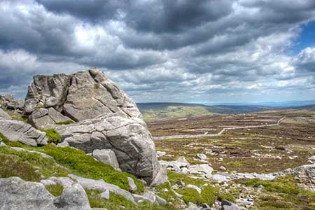
Wolfhole Crags (527 m.) lie on a moorland ridge in the Forest of Bowland and offer extensive views across the surrounding area. The route needs careful navigation and should be avoided in poor visibility. The walk follows a good track onto the ridge which is followed east to Wolfhole Crags. The descent is initially guided by a wall of fence but later requires very careful route finding with only a faint path. A short section of the walk follows the Wyre Way.
The start is small parking area just east of Tower Lodge (grid ref. SD604539). After parking cross the road to join a track to the left of the lodge as indicated by a fingerpost. You are now following the Wyre Way. After 300 metres the path turns left with adjacent sign. The onward route crosses pasture to a ladder stile. Once across the stile turn right, pass through a gate in a wall, and head downhill beside a wall to a stile. The path continues ahead to join a track between two buildings. Cross a bridge, head half-left across a field past Gilberton Farm to cross a bridge over Tarnbrook Wyre (grid ref. SD595554). Follow the farm's drive to where it bends left.
Turn sharp right along a clear track. Follow this track, keeping ahead at all junctions, climbing steadily for four kilometres to reach a metal gate (grid ref. SD618583). Turn right before the gate and follow the fence towards the rounded hill ahead. The path is wet in places but mostly you can avoid wet feet. You reach a junction of a fence and wall (grid ref. SD626578). Continue ahead for a further 500 metres with a wall on your left to reach the summit rocks of Wolfhole Crag which are marked with an OS trig column.
To start the descent, return to the junction of wall and fence. Head through the kissing gate and turn left to Millers House. Follow the fence on your left downhill. As you descend the fence becomes a wall as you cross Brennand Great Hill. Continue the descent to the ruins of Millers House (grid ref. SD622555). Once a hive of activity, today a few millstones give a clue to the former industry. There is little evidence of the concessionary path marked on OS maps. However, head southwest and after 500 metres you will reach a wall. Turn right along the wall and follow the wall for just over two kilometres to reach a gate and ladder stile (grid ref. SD603543). Turn left and descend to Tower Lodge.
Other walks nearby
| Walk 1218 | Fiensdale Head & Bleasdale Water | moderate | 10.0 miles |
| Walk 2278 | Ward's Stone from Stoops Bridge | mod/hard | 13.0 miles |
| Walk 3459 | Abbeystead Reservoir Circular | easy | 1.6 miles |
| Walk 3457 | Wyre Valley Circular | easy/mod | 6.4 miles |
| Walk 2594 | Totridge Fell & Fiendsdale Head, Forest of Bowland | moderate | 11.0 miles |
| Walk 3505 | Whitewell via Crag Stones from Dunsop Bridge | easy/mod | 8.5 miles |
| Walk 2508 | Dunsop Fell & the Forest of Bowland | moderate | 10.0 miles |
| Walk 2510 | Totridge Fell via Langden & Bleadale Water | mod/hard | 10.0 miles |
| Walk 2555 | Whitendale from Dunsop Bridge | moderate | 8.0 miles |
| Walk 2556 | Whitendale & Dunsop Fell from Dunsop Bridge | mod/hard | 15.0 miles |
Recommended Books & eBooks
Walking on the West Pennine Moors
 This guidebook describes 30 walks on the West Pennine Moors, around Blackburn, Darwen, Chorley and Bolton, home to some of the most inspiring and exhilarating walking country. The walks range from short, easy rambles to more challenging hikes covering a variety of terrain, all of it easily accessible for day walking.
More information
Walking in the Forest of Bowland and Pendle
 A guidebook to 40 diverse circular day walks suitable for walkers with navigational skills. The Forest of Bowland and Pendle are two of north west England's upland AONBs, perfect for walkers who enjoy exploring rough hilly, sometimes pathless terrain. The routes include Ward's Stone, Pendle Hill, Longridge Fell and Fair Snape Fell.
More information
Messaging & Social Media
Message Walking Britain and follow the latest news.

Mountain Weather
Stay safe on the mountains with detailed weather forecasts - for iOS devices or for Android devices.