Church Bay & Mynydd y Garn from Swtan
Isle of Anglesey Walk
County/Area - Isle of Anglesey
Author - Lou Johnson
Length - 6.0 miles / 9.8 km Ascent - 695 feet / 211 metres
Time - 3 hours 40 minutes Grade - easy/mod
Maps 

| Ordnance Survey Explorer 262 | Sheet Map | 1:25k | BUY |
| Anquet OS Explorer 262 | Digital Map | 1:25k | BUY |
| Ordnance Survey Landranger 114 | Sheet Map | 1:50k | BUY |
| Anquet OS Landranger 114 | Digital Map | 1:50k | BUY |
Walk Route Description
Click image to visit gallery of 6 images.
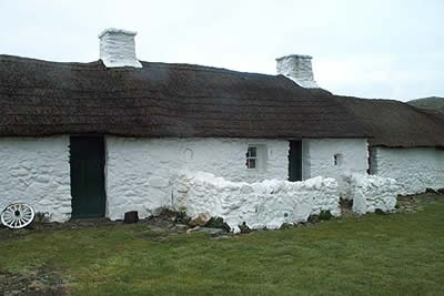
This route visits the northwest coast of Anglesey. It includes a fine section of coastal path, a wander through unspoilt countryside and the bonus of short but rewarding climb to the summit of a rocky hill. The start is the village of Swtan reached by using lanes from the A5025 Valley to Cemaes road. There is a car park (Grid ref. SH301890) adjacent to the National Trust's fine thatched cottage in the village.
Exit the car park and turn left towards the sea turning right onto the signed footpath along the cliffs. Ignore all paths on your right and stay on this path as it wends its way along the cliffs. The current Explorer map shows the footpath as ending at the small stream Gwter Fudr. However a concessionary path now continues all the way round Carmel Head. On the day this walk was researched heavy seas and gale force winds made the clifftop route rather 'interesting' with large amounts of seawater deposited at regular intervals across the path!
Like any clifftop path there is plenty of ascent and descent although nothing too strenuous. At certain times of the year this is one of the finest parts of Britain to witness large concentrations of seabirds with the Auk family (including Puffins) being well represented. Reaching Llyn Fydlyn (Grid ref. 293916) it is time to turn inland although you may want to spend some time making a short detour to Carmel Head, which adds about a mile or so to the route.
From Llyn Fydlyn take the waymarked path inland to reach a small car park (Grid ref. 303915) and a lane. Turn right along the lane and walk south. The roads in this part of Anglesey are quiet and should be able to walk with little disturbance to the peace and quiet. Stay on the lane passing Orsedd Goch, a large farm on your right. Just after on the opposite side of the road look out for a wooden stile. It is not waymarked but is almost adjacent to the field boundary (Grid ref. 306904). Cross the stile and head across fields to reach a lane (Grid ref. 311911). Turn right past Waen-lydan on your right with the rocky outcrop and monument of Mynydd y Garn ahead to your left.
A concessionary path links the lane to the summit, which despite its modest height of 170 metres provides excellent views along the coast and over northwest Anglesey. Despite inclement weather during this visit, it was possible to appreciate the extensive panoramas that this hill provides. After taking in the view return to the lane and turn left downhill. The lane leads you past the church and back into Swtan and the start.
Other walks nearby
| Walk 3580 | Carmel Head & the Skerries from near Cemlyn Bay | easy | 4.5 miles |
| Walk 2933 | Dinas Gynfor from Cemaes Bay, Anglesey | easy | 4.0 miles |
| Walk 3039 | Holyhead Mountain | easy/mod | 4.5 miles |
| Walk 1702 | Rhoscolyn Headland | easy | 5.5 miles |
| Walk 3043 | Llanddwyn Island from Newborough | easy | 4.0 miles |
| Walk 3373 | Foryd Bay | easy | 5.6 miles |
| Walk 1315 | Drosgl and Gyrn Wigau from Rachub | moderate | 7.5 miles |
| Walk 2833 | Moel Faban, Gyrn & Moel Wnion from Rachub | easy/mod | 5.0 miles |
| Walk 1453 | Elidir Fawr, Mynydd Perfedd & Marchlyn Mawr reservoir | moderate | 6.0 miles |
| Walk 3057 | Moel Eilio from Llanberis | moderate | 7.0 miles |
Recommended Books & eBooks
No suggestions for this area.Messaging & Social Media
Message Walking Britain and follow the latest news.

Mountain Weather
Stay safe on the mountains with detailed weather forecasts - for iOS devices or for Android devices.