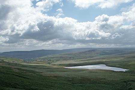
March Haigh Reservoir & Eastergate Bridge from Marsden
South Pennines Walk
Region - South Pennines
County/Area - West Yorkshire - South Pennines
Author - Lou Johnson
Length - 5.0 miles / 8.1 km Ascent - 880 feet / 267 metres
Time - 3 hours 20 minutes Grade - easy/mod
Maps 

| Ordnance Survey Explorer OL21 | Sheet Map | 1:25k | BUY |
| Anquet OS Explorer OL21 | Digital Map | 1:25k | BUY |
| Ordnance Survey Landranger 110 | Sheet Map | 1:50k | BUY |
| Anquet OS Landranger 110 | Digital Map | 1:50k | BUY |
Walk Route Description
Click image to see photo description.
The moors surrounding Marsden have influenced the history of the village. They have provided challenges for transportation, which are still evident toady, the source of power for the watermills of the woollen industry and grazing for the sheep providing some of the wool for weaving. This route uses canal towpath, moorland path and an old packhorse route to explore the lower moors to the west of the village. In addition to being a good walk, you get to sample some of Marsden's industrial past and enjoy the fresh moorland air.
The start is the Standedge Visitor Centre Car Park (Grid ref. SE047118) with its large car park just to the east of the railway station. From here walk west along the canal towpath following the many signs for Standedge Tunnel. Just before the tunnel entrance cross the canal and, keeping to the left of the visitor's centre follow the access road up to the Tunnel End pub. Take the footpath to the right and around the rear of the pub, to a track. Go left along this past Berry Greave. The track becomes a footpath and this leads without any navigational problems to a lane below Lower Green Owlers (Grid ref. SE028126).
Turn right up this tarmac lane passing a house on the right. Take the track on your left toward Hatter Lee. Just before this farmhouse is reached turn left onto the signed footpath (Grid ref. SE028127). Well walked this footpath leads you along the northern rim of Haigh Clough to the dam across March Haigh Reservoir. Bear left and climb up to the southern end of the dam (Grid ref. SE016127). This makes a pleasant place to rest enjoying the solitude of the valley.
The onward route follows a clear path heading south across the moor. This path is not marked on maps but is well walked and will lead you to the old packhorse route at grid ref. SE015125. Turn left here and continue downhill to the picturesque Eastergate Bridge (Close Gate on OS maps). Cross the bridge and follow the river downstream to Waters Road.
Turn right along Waters Road looking out for an attractive iron sculpture in the wall on your left by Hey Green Hotel. A new footpath has been constructed to the right of Waters Road and this is a more attractive option than walking the road. Reaching the Tunnel End pub, turn right down the access road to the canal. Cross the canal and follow the towpath back to the start.
Other walks nearby
| Walk 2613 | Boundary Walk from Marsden | moderate | 13.0 miles |
| Walk 1587 | Scammonden Reservoir | easy | 4.0 miles |
| Walk 2561 | Digley & Ramsden Reservoirs from Wessenden Head | moderate | 9.5 miles |
| Walk 2719 | Huddersfield's green fringe | easy/mod | 10.0 miles |
| Walk 2518 | Black Hill & Four Reservoirs from near Wessenden Head | moderate | 10.0 miles |
| Walk 1586 | Blackmoorfoot Reservoir | easy | 1.5 miles |
| Walk 2914 | The Pots & Pans from Uppermill | easy/mod | 4.5 miles |
| Walk 2634 | Broadstone Hill & the Cotton Famine Road | moderate | 7.0 miles |
| Walk 1583 | Digley Reservoir | easy/mod | 5.0 miles |
| Walk 1091 | Ripponden and the Calderdale Way | easy/mod | 6.5 miles |
Recommended Books & eBooks
No suggestions for this area.Messaging & Social Media
Message Walking Britain and follow the latest news.

Mountain Weather
Stay safe on the mountains with detailed weather forecasts - for iOS devices or for Android devices.