Roseberry Topping and Captain Cook's Monument
North York Moors Walk
Nat Park - North York Moors - North York Moors West
County/Area - Redcar and Cleveland & North Yorkshire
Author - Jim Farrow
Length - 6.3 miles / 10.2 km Ascent - 1700 feet / 515 metres
Time - 4 hours 50 minutes Grade - easy/mod
Maps 

| Ordnance Survey Explorer OL26 | Sheet Map | 1:25k | BUY |
| Anquet OS Explorer OL26 | Digital Map | 1:25k | BUY |
| Ordnance Survey Landranger 93 | Sheet Map | 1:50k | BUY |
| Anquet OS Landranger 93 | Digital Map | 1:50k | BUY |
Walk Route Description
Click image to see photo description.
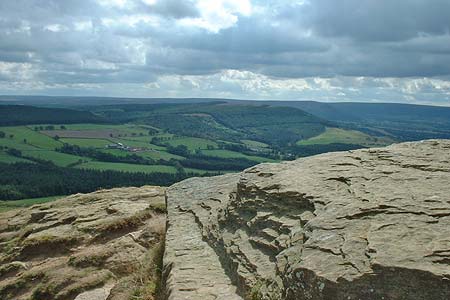
This enjoyable North York Moors walk combines two notable features of the northern part of this National Park into one walk. The first objective, Roseberry Topping, can be very busy with visitors so if you value your peace and quiet then make an early start. Having gained some height the onward route to Captain Cook's Monument provides good views.
We started at the car park (Grid ref. NZ570128) on the A171 road and followed the path (Roseberry Lane) easterly. We took the direct path to the summit of Roseberry Topping (Grid ref. NZ578125). Descending eastwards follow the Clevaland Way behind Slacks Wood and down to the car park (Grid ref. NZ592109) on the lane above Great Ayton station. Leaving the car park, and the ice cream van, it was south and uphill to Captain Cook's Monument (Grid ref. NZ589101) where we watched the paragliders and did a bit of exploration. The return follows the outward route.
Other walks nearby
| Walk 1330 | Roseberry Topping & Captain Cook's Monument | easy/mod | 6.5 miles |
| Walk 1467 | Cleveland Way - Roseberry Common to Tidy Brown Hill | moderate | 15.0 miles |
| Walk 3165 | Roseberry Topping & Highcliff Nab from Eston | moderate | 14.3 miles |
| Walk 3319 | Eston Moor from Flatts Lane | easy | 3.0 miles |
| Walk 1050 | Highcliff Nab & Roseberry Topping from Slapewath | moderate | 10.5 miles |
| Walk 2685 | Highcliff Nab and Guisborough Moor | moderate | 11.1 miles |
| Walk 1468 | Wain Stones, Bank Foot & Bloworth Crossing | moderate | 14.3 miles |
| Walk 1538 | Baysdale Circular | moderate | 9.5 miles |
| Walk 1469 | Carlton Bank, Scugdale, Raisdale & Kirby Bank | moderate | 10.5 miles |
| Walk 3418 | Cringle Moor & the Wain Stones | easy/mod | 6.0 miles |
Recommended Books & eBooks
No suggestions for this area.Messaging & Social Media
Message Walking Britain and follow the latest news.

Mountain Weather
Stay safe on the mountains with detailed weather forecasts - for iOS devices or for Android devices.