Esklets and Rosedale Head from Westerdale
North York Moors Walk
Nat Park - North York Moors - North York Moors West
County/Area - North Yorkshire
Author - Lou Johnson
Length - 11.0 miles / 17.9 km Ascent - 1300 feet / 394 metres
Time - 6 hours 50 minutes Grade - moderate
Maps 

| Ordnance Survey Explorer OL26 | Sheet Map | 1:25k | BUY |
| Anquet OS Explorer OL26 | Digital Map | 1:25k | BUY |
| Ordnance Survey Landranger 94 | Sheet Map | 1:50k | BUY |
| Anquet OS Landranger 94 | Digital Map | 1:50k | BUY |
Walk Route Description
Click image to visit gallery of 12 images.
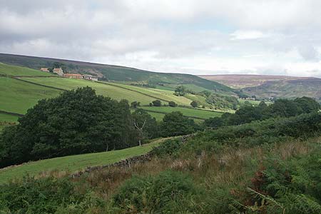
This lengthy route in the North York Moors National Park explores the source of the River Esk, uses a section of the long since abandoned railway serving mines in Rosedale and offers superb views into four dales. The walk does not involve any steep climbs and despite its length is relatively easy with the option of stopping for a pub lunch half way round.
The start is in the small village of Westerdale (Grid ref. NZ664058) where free parking is available at the Village Hall. The walk starts by following the lane that leaves the main road through the village just north of the church. The lane bends right and then left past the hall. Continue straight ahead past Hall Farm, cross the infant River Esk and follow the lane right as it climbs to a cross track (Grid ref. NZ655051). Turn left here along the track towards New House Farm. Before reaching the farm, take the signed path on your left to "Esklets". This leads across meadows, over the farm access track to Hill House and a further meadow to reach Wood End. The path goes to the right of this house and continues to reach a ford (Grid ref. NZ 651035).
Cross the footbridge beside the ford and turn right upstream. The path is very muddy near the start but improves as progress is made up the valley. The path is generally clear underfoot although chest high bracken made progress slow at the height of summer. The route is running on the east side of the river until a small footbridge is reached (Grid ref. NZ656022). Cross this and make your way through the deserted walled enclosures of Esklets Farm. The path becomes a track and this is followed uphill with a short steep section to reach the route of the old railway that served the mines in Rosedale (Grid ref. NZ653007). Turn left along the trackbed and continue for 2 miles. To your right there are superb views into Farndale and with easy walking on an excellent path you are free to enjoy the scenery.
Approximately 300 metres after crossing Blakeley Gill (Grid ref NZ672999) turn left up alongside a derelict wall towards the Lion Inn Public House (food and refreshments are available during opening hours). Reaching the main road, cross over and turn left and walk along the grass verge. To your right is Rosedale and you can see the continuing route of the railway on the far side of the dale. The road is generally relatively quiet and the walk not too tedious. After about a mile, turn right on the signed bridleway that crosses the flank of Wether Hill to White Cross (Grid ref. NZ681019). Cross the road and continue north on the bridleway to reach the main road. Continue north on the grass verge as far as High Crag (Grid ref. NZ682039) from where there is a beautiful view into Danby Dale.
Carefully cross the road and take the signed bridleway descending into Westerdale. The view ahead is superb. Reaching Dale Head, signs clearly direct you through the farm and you soon reach Broad Gate Farm (Grid ref. NZ671049). Continue through the farm yard and follow Broad Gate Road north. At the first junction turn left into Christy Gate Road. At the next junction a right turn will take you back to the start.
Other walks nearby
| Walk 1538 | Baysdale Circular | moderate | 9.5 miles |
| Walk 2685 | Highcliff Nab and Guisborough Moor | moderate | 11.1 miles |
| Walk 3737 | Commondale & Esk Valley | easy/mod | 8.2 miles |
| Walk 1450 | Little & Great Fryup Dales | moderate | 8.3 miles |
| Walk 1527 | Farndale Circular from Little Blakey | moderate | 12.0 miles |
| Walk 1674 | Rosedale Valley circular from Little Blakey | moderate | 11.0 miles |
| Walk 1467 | Cleveland Way - Roseberry Common to Tidy Brown Hill | moderate | 15.0 miles |
| Walk 1468 | Wain Stones, Bank Foot & Bloworth Crossing | moderate | 14.3 miles |
| Walk 2077 | Glaisdale Moor circular | moderate | 11.9 miles |
| Walk 1012 | Glaisdale, Great Fryup Dale and Eskdale | moderate | 7.5 miles |
Recommended Books & eBooks
Trail and Fell Running in the Yorkshire Dales
 Guidebook to 40 of the best trail and fell runs in the Yorkshire Dales National Park. Ranging from 5 to 24 miles, the graded runs start from bases such as Ribblehead, Dent, Sedbergh, Malham and Grassington and take in the region's diverse delights, from castles and waterfalls to iconic mountains such as Whernside, Ingleborough and Pen Y Ghent.
More information
Messaging & Social Media
Message Walking Britain and follow the latest news.

Mountain Weather
Stay safe on the mountains with detailed weather forecasts - for iOS devices or for Android devices.