Snowdon via the South Ridge & Rhyd-ddu Path
Snowdonia/Eryri Walk
Nat Park - Snowdonia - Snowdon Crib Goch
County/Area - Gwynedd
Author - Lou Johnson
Length - 7.5 miles / 12.2 km Ascent - 3000 feet / 909 metres
Time - 6 hours 50 minutes Grade - mod/hard
Maps 

| Ordnance Survey Explorer OL17 | Sheet Map | 1:25k | BUY |
| Anquet OS Explorer OL17 | Digital Map | 1:25k | BUY |
| Ordnance Survey Landranger 115 | Sheet Map | 1:50k | BUY |
| Anquet OS Landranger 115 | Digital Map | 1:50k | BUY |
Walk Route Description
Click image to visit gallery of 12 images.
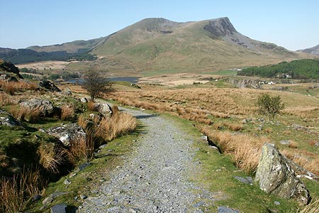
Snowdon is one of the most popular summits in the British Isles seeing many thousands of visitors each year. A good proportion of these use the railway, whilst the remainder walk all the way to the summit perhaps having a greater sense of achievement as they enjoy the view from the summit cairn. This route, using the South Ridge for the ascent and the Rhyd-ddu path for the descent, offers a much quieter way to the top although for the last section it is hard to avoid the crowds.
The start of this Snwodonia is the large pay and display car park at Rhyd-ddu (grid ref. SH571526) adjacent to the Welsh Highland Railway station. Walk to the Rhyd-ddu village end of the station, cross the tracks using the purpose-built crossing and follow the clear track that heads southeast uphill towards Bwlch-Cwm Llan. It is a straightforward walk with the track allowing a fast pace along what was once an access road to the quarries and mines to the north of Yr Aran. The route passes through a number of areas where evidence of slate quarrying is evident and soon you pass two small lakes on your right hand side.
Reaching Bwlch-Cwm Llan (grid ref SH605521), you are in the col between Yr Aran on your right and Snowdon to your left. Ahead is the vast cwm located below Snowdon's south face. Turn left here (north) and start the walk up Snowdon's South Ridge. The path is always easy to follow offering improving views as height is gained. A few sections require the occasional use of hands but nothing is difficult or beyond the reach of normal walkers. Generally speaking you have steep crags on your right and gentler slopes to your left at least until the point where the Rhyd-ddu path joins the ridge for the final section to the summit.
From the point where the Rhyd-ddu path joins the South Ridge (grid ref SH604536), you follow a narrowing arete (Bwlch Main) for a short but exciting section of path. There is no technical difficulty although a head for heights is required. Soon the path climbs more steeply again for the final climb to the summit. This is soon recognised by the crowds of people, who have been noticeable for their absence so far on this route. If you have never been to Snowdon's summit before, then the view is recommended especially east over Glaslyn and Llyn Llydaw. If, like me, you have been there before, then a short break away from the summit area is far preferable perhaps gazing at the wonderful series of summits and crags forming Y Lliwedd.
To return to Rhyd-ddu retrace you steps across Bwlch Main and at the far end of the arete bear right and follow the clear path as it zigzags down the mountainside towards Rhyd-ddu. The descent is good and progress fast on the well graded path. As you near the bottom, the path twists and turns a little as it crosses the rocky landscape. Soon you reach the track used on the outward half of the route (grid ref. SH582524). Turn right here for the final section along the track back to the start.
Other walks nearby
| Walk 3613 | Moel Cynghorion from Llyn Cwellyn | moderate | 5.0 miles |
| Walk 3060 | Moel Lefn & Moel yr Ogof | moderate | 7.0 miles |
| Walk 2150 | Llyn Dinas and Cwm Bychan from Beddgelert | easy/mod | 6.0 miles |
| Walk 2560 | Moel Hebog, Moel yr Ogof & Moel Lefn from Beddgelert | mod/hard | 6.5 miles |
| Walk 1799 | Moel Hebog | moderate | 5.5 miles |
| Walk 1988 | Beddgelert, Moel Hebog, Meol yr Ogof & Moel Lefn | mod/hard | 6.8 miles |
| Walk 3074 | Mynydd Sygun | moderate | 4.5 miles |
| Walk 3231 | Moel Hebog, Meol yr Ogof and Moel Lefn from Beddgelert | mod/hard | 6.8 miles |
| Walk 1426 | Aberglaslyn and Cwm Bychan | easy/mod | 5.8 miles |
| Walk 1427 | Craflwyn circular from near Beddgelert | easy/mod | 2.5 miles |
Recommended Books & eBooks
The Wales Coast Path
 A single guidebook to walking the whole Wales Coast Path - 1400km (870 miles) the length of Wales from Chester to Chepstow, including Anglesey, described in 57 stages. The route passes through the Snowdonia and Pembrokeshire National Parks and many AONBs and can be linked with the Offa's Dyke Path for a complete circuit of Wales.
More information
Snowdonia: 30 Low-level and easy walks - North
 Guidebook describing 30 walks in Snowdonia, Wales. Routes are mostly low level and on clear paths and showcase the region's beautiful scenery and rich history and culture. Part of a 2-volume set, this northern volume includes the Snowdon area, the Ogwen and Conwy Valleys, Betws-y-Coed, Beddgelert, Ffestiniog and the coast.
More information
Messaging & Social Media
Message Walking Britain and follow the latest news.

Mountain Weather
Stay safe on the mountains with detailed weather forecasts - for iOS devices or for Android devices.